Anmoore, West Virginia

Last updated

Anmoore, West Virginia
Logo of Anmoore, West Virginia.svg
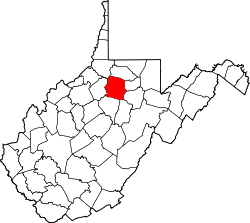
Harrison County West Virginia Incorporated and Unincorporated areas Anmoore Highlighted.svg
Location of Anmoore in Harrison County, West Virginia.
Coordinates: 39°15′30″N80°17′17″W / 39.25833°N 80.28806°W / 39.25833; -80.28806
Country United States
State West Virginia
County Harrison
Government
  MayorP. Eddie Hardman
Area
[1]
  Total1.06 sq mi (2.74 km2)
  Land1.06 sq mi (2.74 km2)
  Water0.00 sq mi (0.00 km2)
Elevation
1,014 ft (309 m)
Population
 (2020) [2]
  Total514
  Estimate 
(2021) [2]
508
  Density694.42/sq mi (268.17/km2)
Time zone UTC-5 (Eastern (EST))
  Summer (DST) UTC-4 (EDT)
ZIP code
26323
Area code 304
FIPS code 54-01900 [3]
GNIS feature ID1534961 [4]
Website https://www.anmoorewv.com/

Anmoore is a town in Harrison County, West Virginia, United States. It is located at the intersection of WV 58 and Interstate 79. The population was 514 at the 2020 census. [2]

Contents

The town derives its name from nearby Ann Moore Run. [5]

Geography

Anmoore is located at 39°15′30″N80°17′17″W / 39.25833°N 80.28806°W / 39.25833; -80.28806 (39.258328, -80.287987). [6]

According to the United States Census Bureau, the town has a total area of 1.06 square miles (2.75 km2), all land. [7]

History

The community was first settled by Andrew Cottrill (1736–1781) in 1772.

In 1903, 453 acres were purchased to create the Steelton Addition to the city of Clarksburg and representatives of the Cleveland, Ohio based Grasselli Chemical company agreed to locate a plant on the property. [8] [9] In May 1904, operations began at the first unit of the chemical plant employing 50. [10] In June 1904, plans were developed to construct houses to rent to plant employees. [11] Many of the workers were immigrants from Asturias, Spain. [12] In 1917, a post office was established and given the name of Anmoore. [13] In December 1950, the city was incorporated and Victor Gonzalez was elected the first mayor. [14]

Demographics

Historical population
CensusPop.Note
1960 1,050
1970 944−10.1%
1980 865−8.4%
1990 686−20.7%
2000 685−0.1%
2010 77012.4%
2020 514−33.2%
2021 (est.)508 [2] −1.2%
U.S. Decennial Census [15]

2010 census

As of the census [16] of 2010, there were 770 people, 303 households, and 197 families living in the town. The population density was 726.4 inhabitants per square mile (280.5/km2). There were 343 housing units at an average density of 323.6 per square mile (124.9/km2). The racial makeup of the town was 97.0% White, 1.3% African American, 0.4% Native American, 0.4% Asian, and 0.9% from two or more races. Hispanic or Latino of any race were 1.7% of the population.

There were 303 households, of which 38.3% had children under the age of 18 living with them, 39.3% were married couples living together, 21.1% had a female householder with no husband present, 4.6% had a male householder with no wife present, and 35.0% were non-families. 29.7% of all households were made up of individuals, and 13.2% had someone living alone who was 65 years of age or older. The average household size was 2.54 and the average family size was 3.17.

The median age in the town was 32 years. 27.7% of residents were under the age of 18; 10.5% were between the ages of 18 and 24; 27.2% were from 25 to 44; 23.3% were from 45 to 64; and 11% were 65 years of age or older. The gender makeup of the town was 46.4% male and 53.6% female.

2000 census

As of the census [3] of 2000, there were 685 people, 270 households, and 186 families living in the town. The population density was 641.1 inhabitants per square mile (247.2/km2). There were 325 housing units at an average density of 304.2 per square mile (117.3/km2). The racial makeup of the town was 97.08% White, 1.17% African American, 0.15% Native American, 0.88% Asian, and 0.73% from two or more races. Hispanic or Latino of any race were 3.50% of the population.

There were 270 households, out of which 31.1% had children under the age of 18 living with them, 49.6% were married couples living together, 13.7% had a female householder with no husband present, and 31.1% were non-families. 25.9% of all households were made up of individuals, and 13.0% had someone living alone who was 65 years of age or older. The average household size was 2.54 and the average family size was 3.10.

In the town, the population was spread out, with 24.8% under the age of 18, 11.1% from 18 to 24, 28.2% from 25 to 44, 21.2% from 45 to 64, and 14.7% who were 65 years of age or older. The median age was 34 years. For every 100 females, there were 95.7 males. For every 100 females age 18 and over, there were 92.9 males.

The median income for a household in the town was $25,000, and the median income for a family was $26,705. Males had a median income of $22,500 versus $20,000 for females. The per capita income for the town was $10,948. About 23.0% of families and 27.1% of the population were below the poverty line, including 39.6% of those under age 18 and 5.9% of those age 65 or over.

Notable People

Related Research Articles

<span class="mw-page-title-main">Harrison County, West Virginia</span> County in West Virginia, United States

Harrison County is a county in the U.S. state of West Virginia. As of the 2020 census, the population was 65,921. Its county seat is Clarksburg.

<span class="mw-page-title-main">Ferndale, Pennsylvania</span> Borough in Pennsylvania, United States

Ferndale is a borough in Cambria County, Pennsylvania, United States. It is part of the Johnstown, Pennsylvania Metropolitan Statistical Area. The population was 1,636 at the 2010 census, down from 1,834 at the 2000 census.

<span class="mw-page-title-main">Clarksburg, Tennessee</span> Town in Tennessee, United States

Clarksburg is a town in Carroll County, Tennessee, United States. The population was 393 at the 2010 census. Clarksburg has its own high school.

<span class="mw-page-title-main">Flatwoods, West Virginia</span> Town in West Virginia, United States

Flatwoods is a town in Braxton County, West Virginia, United States, located approximately one mile from exit 67 of Interstate 79.

<span class="mw-page-title-main">Gassaway, West Virginia</span> Town in West Virginia, United States

Gassaway is a town in Braxton County, West Virginia, United States. The population was 769 at the 2020 census. Gassaway was incorporated in 1905 and named for Henry Gassaway Davis, the Democratic Party's nominee for Vice President of the United States in 1904. The center of population of West Virginia is located approximately 7 miles (11 km) north of Gassaway.

<span class="mw-page-title-main">West Union, West Virginia</span> Town in West Virginia

West Union, incorporated July 20, 1881, is a town and the county seat of Doddridge County, West Virginia, United States. The population was 669 at the 2020 census. The town is located along Middle Island Creek at the junction of U.S. Route 50 and West Virginia Route 18; the North Bend Rail Trail also passes through the town.

<span class="mw-page-title-main">Bridgeport, West Virginia</span> City in West Virginia, United States

Bridgeport is a city in eastern Harrison County, West Virginia, United States. The population was 9,325 at the 2020 census. It is part of the Clarksburg micropolitan area in North Central West Virginia. Bridgeport had its beginning in pre-American Revolutionary War times. In 1764, John Simpson entered the area and gave his name to Simpson Creek. Bridgeport was chartered in 1816.

<span class="mw-page-title-main">Clarksburg, West Virginia</span> City in West Virginia, United States

Clarksburg is a city in and the county seat of Harrison County, West Virginia, United States, in the north-central region of the state. The population of the city was 16,039 at the 2020 census, making it the tenth-largest city in West Virginia. It is the principal city of the Clarksburg micropolitan area, which had a population of 90,434 in 2020. Clarksburg was named National Small City of the Year in 2011 by the National League of Cities.

<span class="mw-page-title-main">Nutter Fort, West Virginia</span> Town in West Virginia, United States

Nutter Fort is a town in Harrison County, West Virginia, United States, incorporated in 1923. The town is a southeastern suburb of Clarksburg.

<span class="mw-page-title-main">Weston, West Virginia</span> City in West Virginia, United States

Weston is a city in and the county seat of Lewis County, West Virginia, United States. The population was 3,943 at the 2020 census. It is home to the Museum of American Glass in West Virginia and the Trans-Allegheny Lunatic Asylum.

<span class="mw-page-title-main">Worthington, West Virginia</span> Town in West Virginia, United States

Worthington is a town in Marion County, West Virginia, United States. The population was 158 at the 2010 census. Worthington was incorporated in 1893 and named for Colonel George Worthington, an early settler. U.S. Route 19 passes through the town.

<span class="mw-page-title-main">Glen Dale, West Virginia</span> Town in West Virginia

Glen Dale is a city in Marshall County, West Virginia, United States, along the Ohio River. It is part of the Wheeling, West Virginia Metropolitan Statistical Area. The population was 1,514 at the 2020 census. Glen Dale was incorporated in 1924. It is in the northwest part of the county, which is above the Mason–Dixon line and forms the base of the Northern Panhandle of West Virginia.

<span class="mw-page-title-main">Hartford City, West Virginia</span> Town in West Virginia, United States

Hartford City, also known as Hartford, is a town in Mason County, West Virginia, United States. The population was 509 at the 2020 census. It is part of the Point Pleasant, WV–OH Micropolitan Statistical Area.

<span class="mw-page-title-main">West Liberty, West Virginia</span> Town in West Virginia, United States

West Liberty is a town in Ohio County, West Virginia, United States. The population was 1,557 at the 2020 census. It is part of the Wheeling metropolitan area.

<span class="mw-page-title-main">Bruceton Mills, West Virginia</span> Town in West Virginia, United States

Bruceton Mills is a town in northern Preston County, West Virginia, United States, along Big Sandy Creek. The population was 64 at the 2020 census, making it the second-least populous town in West Virginia, after Thurmond. It is part of the Morgantown metropolitan area.

<span class="mw-page-title-main">Kingwood, West Virginia</span> City in West Virginia, United States

Kingwood is a city in and the county seat of Preston County, West Virginia, United States. The population was 2,980 at the 2020 census. The city sits within the Allegheny Mountains above the Cheat River valley. It is part of the Morgantown metropolitan area.

<span class="mw-page-title-main">Tunnelton, West Virginia</span> Town in West Virginia, United States

Tunnelton is a town in southwestern Preston County, West Virginia, United States. The population was 307 at the 2020 census. It is part of the Morgantown metropolitan area.

<span class="mw-page-title-main">Hurricane, West Virginia</span> City in West Virginia, United States

Hurricane is a city in Putnam County, West Virginia, United States. The population was 6,977 at the 2020 census. Located roughly equidistant from Charleston and Huntington, it is part of the Huntington–Ashland metropolitan area.

<span class="mw-page-title-main">Pennsboro, West Virginia</span> City in West Virginia, United States

Pennsboro is a city in Ritchie County, West Virginia, United States. The population was 1,050 at the 2020 census. The city is located at the junction of U.S. Route 50 and West Virginia Route 74; the North Bend Rail Trail also passes through the city.

<span class="mw-page-title-main">Middlebourne, West Virginia</span> Town in West Virginia, United States

Middlebourne is a town and the county seat of Tyler County, West Virginia, United States. The population was 715 at the 2020 census.

References

  1. "2019 U.S. Gazetteer Files". United States Census Bureau. Retrieved August 7, 2020.
  2. 1 2 3 4 Bureau, US Census. "City and Town Population Totals: 2020-2021". Census.gov. US Census Bureau. Retrieved July 2, 2022.
  3. 1 2 "U.S. Census website". United States Census Bureau . Retrieved January 31, 2008.
  4. "US Board on Geographic Names". United States Geological Survey. October 25, 2007. Retrieved January 31, 2008.
  5. Kenny, Hamill (1945). West Virginia Place Names: Their Origin and Meaning, Including the Nomenclature of the Streams and Mountains. Piedmont, WV: The Place Name Press. p. 80.
  6. "US Gazetteer files: 2010, 2000, and 1990". United States Census Bureau. February 12, 2011. Retrieved April 23, 2011.
  7. "US Gazetteer files 2010". United States Census Bureau. Archived from the original on January 25, 2012. Retrieved January 24, 2013.
  8. "Work Has Started on Gigantic Manufactory at Steelton!". The Daily Telegram. Clarksburg, West Virginia. August 20, 1903. p. 1. Retrieved December 9, 2022.
  9. "Work Started on Steelton's Gigantic Manufactory". The Clarksburg Telegram. Clarksburg, West Virginia. August 21, 1903. Retrieved December 9, 2022.
  10. "Zinc". The Daily Telegram. Clarksburg, West Virginia. May 11, 1904. p. 1. Retrieved December 9, 2022.
  11. "Cottages to be Built". The Clarksburg Telegram. Clarksburg, West Virginia. June 3, 1904. p. 11. Retrieved December 9, 2022.
  12. "New Document: Spain's Lost Children in West Virginia (1916), Part One". Spanish Immigrants in the United States. April 27, 2014. Retrieved December 9, 2022.
  13. "Washington News of Interest to West Va". The Wheeling Intelligencer. Wheeling, West Virginia. July 12, 1917. p. 4. Retrieved December 9, 2022.
  14. "Gonzalez Wins First Election at Anmoore". The Charleston Daily Mail. Charleston, West Virginia. December 20, 1950. p. 2.
  15. "Census of Population and Housing". Census.gov. Retrieved June 4, 2015.
  16. "U.S. Census website". United States Census Bureau . Retrieved January 24, 2013.
  17. "Fernandez Will Be Charleston Coach". The Beckley Post-Herald. Beckley, West Virginia. June 6, 1965. p. 20. Retrieved December 9, 2022.