Augusta, Arkansas | |
|---|---|
| City of Augusta | |
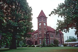 Woodruff County Courthouse in Augusta | |
 Location in Woodruff County and Arkansas | |
 Augusta Location in the United States | |
| Coordinates: 35°17′19″N91°22′09″W / 35.28861°N 91.36917°W | |
| Country | |
| State | |
| County | Woodruff |
| Founded | February 21, 1848 |
| Incorporated | July 9, 1860 |
| Founded by | Thomas Hough |
| Named after | Augusta Cald |
| Area | |
• Total | 2.09 sq mi (5.41 km2) |
| • Land | 2.07 sq mi (5.37 km2) |
| • Water | 0.02 sq mi (0.04 km2) |
| Elevation | 217 ft (66 m) |
| Population (2020) | |
• Total | 1,998 |
• Estimate (2024) | 1,848 |
| • Density | 964.29/sq mi (372.25/km2) |
| Time zone | UTC−06:00 (Central (CST)) |
| • Summer (DST) | UTC−05:00 (CDT) |
| ZIP Code | 72006 |
| Area code | 870 |
| FIPS code | 05-02740 |
| GNIS feature ID | 2403137 [2] |
Augusta, officially the City of Augusta, is a city in Woodruff County, Arkansas, United States, located on the east bank of the White River. The population was 1,998 as of the 2020 Census. [3] The city is the county seat of Woodruff County. [4]

