
The Mendip Hills is a range of limestone hills to the south of Bristol and Bath in Somerset, England. Running from Weston-super-Mare and the Bristol Channel in the west to the Frome valley in the east, the hills overlook the Somerset Levels to the south and the Chew Valley and other tributaries of the Avon to the north. The hills give their name to the local government district of Mendip, which administers most of the area. The higher, western part of the hills, covering 198 km2 (76 sq mi) has been designated an Area of Outstanding Natural Beauty (AONB), which gives it a level of protection comparable to a national park.

Brean Down is a promontory off the coast of Somerset, England, standing 318 feet (97 m) high and extending 1.5 miles (2 km) into the Bristol Channel at the eastern end of Bridgwater Bay between Weston-super-Mare and Burnham-on-Sea.

Winscombe is a large village in the North Somerset unitary district of Somerset, South West England, close to the settlements of Axbridge and Cheddar, on the western edge of the Mendip Hills, 7 miles (11 km) southeast of Weston-super-Mare and 14 miles (23 km) southwest of Bristol. The Parish of Winscombe and Sandford, centred on the Parish Church of Church of St James the Great, includes the villages/hamlets of Barton, Hale, Oakridge, Nye, Sidcot and Woodborough.

The greater horseshoe bat is an insectivorous bat of the genus Rhinolophus. Its distribution covers Europe, Northern Africa, Central Asia and Eastern Asia. It is the largest of the horseshoe bats in Europe and is thus easily distinguished from other species. The species is sedentary, typically travelling up to 30 kilometres (19 mi) between the winter and summer roosts, with the longest recorded movement being 180 km (110 mi). The frequencies used by this bat species for echolocation lie between 69–83 kHz, have most energy at 81 kHz and have an average duration of 37.4 ms.

The lesser horseshoe bat is a type of small European and North African insectivorous bat, related to its larger cousin, the greater horseshoe bat. As with all horseshoe bats, the species gets its name from its distinctive horseshoe-shaped noseleaf.
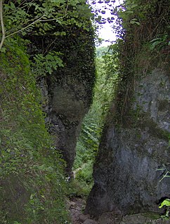
Ebbor Gorge is a limestone gorge in Somerset, England, designated and notified in 1952 as a 63.5-hectare (157-acre) biological Site of Special Scientific Interest in the Mendip Hills. It was donated to the National Trust in 1967 and is now managed by Natural England as a national nature reserve.
Banwell Ochre Caves are a 12.46-hectare geological Site of Special Scientific Interest near the village of Banwell, North Somerset, notified in 1983.

Compton Martin Ochre Mine is a 0.85 hectare geological and biological Site of Special Scientific Interest located on the north side of the Mendip Hills, immediately south west of Compton Martin village, Somerset, notified in 1988.
Brown's Folly or Brown's Folly is a folly tower sitting within a 39.9 hectare biological and geological Site of Special Scientific Interest (SSSI) near the village of Bathford in Somerset, notified in 1974: the site itself is known as the Farleigh Down Stone Quarry, and is managed as a nature reserve by the Avon Wildlife Trust (AWT). The tower was built in 1848 and is a Grade II listed building.

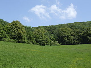
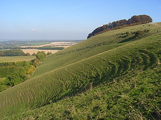
Crook Peak to Shute Shelve Hill is a 332.2 hectare (820.9 acre) geological and biological Site of Special Scientific Interest near the western end of the Mendip Hills, Somerset. The line of hills runs for approximately 5 kilometres (3.1 mi) from west to east and includes: Crook Peak, Compton Hill, Wavering Down, Cross Plain and Shute Shelve Hill. Most of the site is owned by the National Trust, which bought 725 acres (293 ha) in 1985, and much of it has been designated as common land. It was notified as an SSSI by Natural England in 1952.
Cheddar Wood is an 86.9-hectare (215-acre) biological Site of Special Scientific Interest at Cheddar in the Mendip Hills, Somerset, England, notified in 1967.

King John's Hunting Lodge is a wool-merchant's house built c. 1460, long after the death of King John in 1216, in Axbridge, a town in the English county of Somerset. It is a jettied timber-frame building of three storeys, occupying a corner plot on the town square. The building has served a variety of purposes with shops on the ground floor and workshops and living quarters on the first and second floors. At one time part of the building was occupied by the King's Head Inn; a sculpture of a king's head, which acted as a sign for the pub, is preserved within and a replica is attached to the outside. The lodge was bequeathed to the National Trust in 1971, and repairs were undertaken to reverse significant deterioration to the building.

Rodney Stoke is a 69.6 hectare biological Site of Special Scientific Interest, just north of the village of Rodney Stoke in the Mendip Hills, Somerset, notified in 1957.

St. Dunstan's Well Catchment is a Site of Special Scientific Interest, covering 39.8 hectares near Stoke St Michael in the Mendip Hills, Somerset, England. The site was notified in 1967. It is of both geological and biological significance.
The Perch is a 72.1 hectare biological Site of Special Scientific Interest close to Cheddar Gorge in the Mendip Hills, Somerset, England. It received SSSI notification in 1990.
Fonthill Grottoes is a 0.69 hectare biological Site of Special Scientific Interest, in woodland adjacent to Fonthill Lake in Wiltshire, notified in 1994. Its SSSI designation is due to its roosting bats: the site is the sixth largest hibernaculum in Britain.
Old Iron Works, Mells is a 0.25 hectare biological Site of Special Scientific Interest, in the Wadbury Valley, south of the village of Mells in Somerset, notified in 1987. The site is a ruined iron works, which mainly produced agricultural edge-tools that were exported all over the world, and is now, in addition to its unique and major importance in relation to industrial archaeology, used as a breeding site by horseshoe bats. The block of buildings adjacent to the entrance is listed Grade II* and most of the rest of the site is a Scheduled Ancient Monument. It is included in the Heritage at Risk Register produced by English Heritage.
Ham Hill is an area of chalk downland in Wiltshire, England, on the steep banks running alongside the road from the village of Ham to Buttermere, close to the Berkshire border. A biological Site of Special Scientific Interest, notified in 1971, covers 1.5 hectares of the site; this designation is due to the site's species-rich plant and insect communities, which include some rare species. Notable among these is the musk orchid, which has been confirmed at only one other site in Wiltshire.

Trinia glauca (Honewort) is a low-growing umbellifer found in rocky areas.
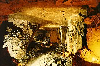
Shute Shelve Cavern is a natural cave system located in Shute Shelve Hill, Somerset, England, above Axbridge in the Mendip Hills not far from Cheddar.

