
Malton is a neighbourhood in the northeastern part of the city of Mississauga, Ontario, Canada, located to the northwest of Toronto.

The Township of Langley is a district municipality immediately east of the City of Surrey in southwestern British Columbia, Canada. It extends south from the Fraser River to the Canada–United States border, and west of the City of Abbotsford. Langley Township is not to be confused with the City of Langley, which is adjacent to the township but politically is a separate entity. Langley is located in the eastern part of Metro Vancouver.

Blossom Park is a neighbourhood in Gloucester-Southgate Ward in the south-end of the city of Ottawa, Ontario, Canada. Before the 2001 city of Ottawa amalgamation it was a suburb of the city of Gloucester. The current limits of the neighbourhood are: Hunt Club Road to the north, Airport Parkway to the west, Conroy Road to the east and the Greenbelt to the south.

Klondike Gold Rush National Historical Park is a national historical park operated by the National Park Service that seeks to commemorate the Klondike Gold Rush of the late 1890s. Though the gold fields that were the ultimate goal of the stampeders lay in the Yukon Territory, the park comprises staging areas for the trek there and the routes leading in its direction. There are four units, including three in Municipality of Skagway Borough, Alaska and a fourth in the Pioneer Square National Historic District in Seattle, Washington.

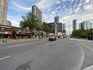
Malvern is a neighbourhood in the city of Toronto, Ontario, Canada, with a population of 44,315. It is located in the northeast corner of the city.
Willowdale is a neighbourhood in the city of Toronto, Ontario, Canada, located in the district of North York. It developed from three postal villages: Newtonbrook, Willowdale and Lansing.

Barrhead is a town in central Alberta, Canada that is surrounded by the County of Barrhead No. 11. It is located along the Paddle River and at the intersection of Highway 33 and Highway 18, approximately 120 km (75 mi) northwest of the City of Edmonton. It is also located along the route of the Express Trail, used by the North West Company, which was originally a First Nations trail. The trail was later widened by George Simpson and John Rowand to save the North West Company over $5,000.
Heritage Park Historical Village is a historical park in Calgary, Alberta, Canada, on 127 acres (51 ha) of parkland on the banks of the Glenmore Reservoir, in the city's southwestern quadrant. The Historical Village part of the park is open 7 days a week (10-5) from the Canadian May long weekend through to the September Labour Day long weekend, and then weekends from Labour Day through to Canadian Thanksgiving weekend in mid October. The Heritage Town Square is open year-round. As one of Canada's largest living history museums, it is one of the city's most visited tourist attractions. Exhibits span western Canadian history from the 1860s to the 1950s. Many of the buildings are historical and were transported to the park to be placed on display. Others are re-creations of actual buildings. Most of the structures are furnished and decorated with genuine artifacts. Staff dress in historic costume, and antique automobiles and horse-drawn vehicles service the site. Calgary Transit provides regular shuttle service from Heritage C-Train station. The park opened on July 1, 1964.
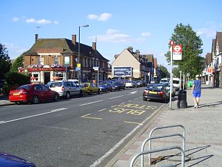
Motspur Park, also known locally as West Barnes, is a residential suburb in south-west London, in the New Malden district. It straddles the boroughs of Kingston upon Thames and Merton.

Waitara is a suburb in the Northern Sydney region of Sydney, in the state of New South Wales, Australia 19 kilometres north-west of the Sydney central business district, in the local government area of Hornsby Shire.

Wauchope ( ) is a town in the Mid North Coast region of New South Wales, Australia. It is within the boundaries of the Port Macquarie-Hastings Council area. Wauchope is inland on the Hastings River and the Oxley Highway 19 km (12 mi) west of Port Macquarie. The town is 383 km (238 mi) north of the state capital Sydney.

Streetcars in Washington, D.C. transported people across the city and region from 1862 until 1962.

Eatonville is a neighbourhood in Toronto, Ontario, Canada. It is located west of the central core, in the former suburb of Etobicoke. Eatonville is bisected by Highway 427, with the community generally located north of Dundas Street West and south of Rathburn Road. Eatonville consists mainly of low density residential homes. The main arterial roads in the community, such as The West Mall, The East Mall and Burnhamthorpe Road, contain a mix of rental and condominium high-rise apartments and townhouses. Cloverdale Mall is in the neighbourhood, and there are community retail areas along Bloor Street West and Dundas Street West.

Gosforth is a suburb of the city and metropolitan borough of Newcastle upon Tyne, England. It constituted a separate urban district from 1895 until 1974 before officially merging with the city of Newcastle upon Tyne. In 2001, it had a population of 23,620.

Brightwood is a neighborhood in the northwestern quadrant of Washington, D.C. Brightwood is part of Ward 4.

Beaver Bank is a suburban community northeast of Lower Sackville on the Beaver Bank Road in Nova Scotia, Canada, within the Halifax Regional Municipality. It is about 35 kilometres from the City of Halifax.

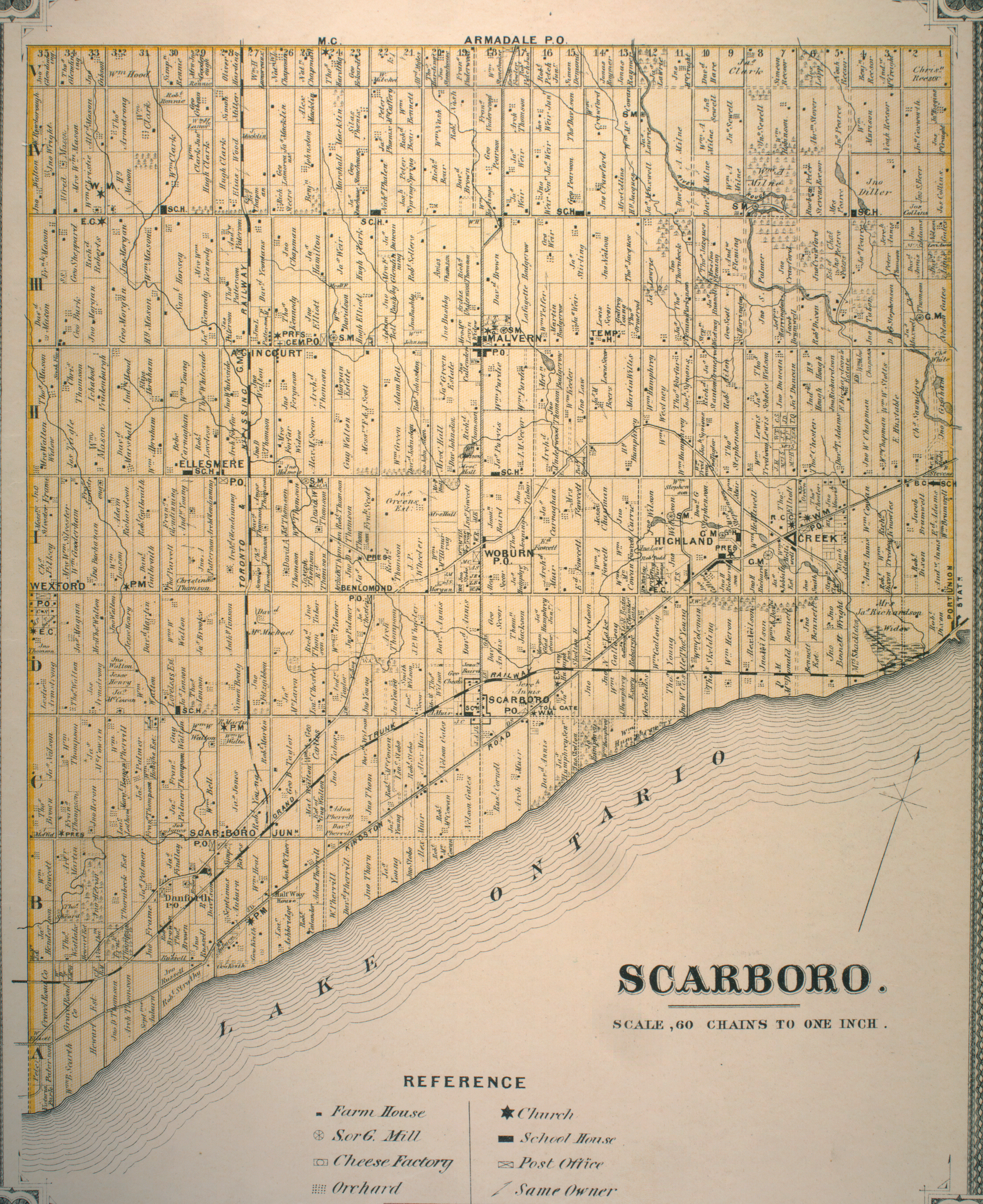
CPR Toronto Yard is a facility located in northeast Toronto, Ontario, Canada owned by the Canadian Pacific Kansas City, often incorrectly referred to as Agincourt Yard because it is located in Agincourt, a neighbourhood of Toronto.

Carlyle is a town in the province of Saskatchewan, Canada. Carlyle is the largest town servicing the far south-eastern corner of Saskatchewan and as a result, has become the economic and services centre of the region. Estevan and Weyburn are the closest cities and both are a little over 100 kilometres away. Regina, the provincial capital, lies 200 km to the north-west.

Girvin is a former village of 20 people in Saskatchewan, Canada. It is located midway between Regina and Saskatoon on Highway 11 between the towns of Davidson and Craik. The village was formally dissolved in 2005; its remaining population is now counted as part of the rural municipality of Arm River.
Banksville is a hamlet in the town of North Castle, Westchester County, New York, United States and an area including Stamford and Greenwich, Connecticut. Estimated to have been founded in the late 1600s, it is an area which had importance for local cottage industries, a boarding school, and local merchants to support its residents in its early days. Banksville was the home of many patriots including veterans who fought in the American Revolution, Civil War and World Wars I and II. Today it remains a vibrant area of neighborhoods that include ancestors from its earliest times.
