Route 36 is a state highway in Monmouth County, New Jersey, United States. The 24.40-mile (39.27 km) long route, shaped as a backwards C, begins at an intersection with the Garden State Parkway and County Route 51 on the border of Tinton Falls and Eatontown and runs east to Long Branch. From Long Branch, the route follows the Atlantic Ocean north to Sea Bright and turns west, running to the south of the Raritan Bay. Route 36 ends in Keyport at an interchange with the Garden State Parkway and Route 35. It varies in width from a six-lane divided highway to a two-lane undivided road. The route is signed east–west between Eatontown and Long Branch and north–south between Long Branch and Keyport.

Loch Arbour is a village in Monmouth County, New Jersey, United States, formed in 1957. It was named after Lochaber, Scotland. As of the 2010 United States Census, the village's population was 194, reflecting a decline of 86 (-30.7%) from the 280 counted in the 2000 Census, which had in turn declined by 100 (-26.3%) from the 380 counted in the 1990 Census. As of 2010, Loch Arbour was the third-smallest municipality in New Jersey in terms of area and was the fifth-smallest municipality by population in the state of New Jersey. Based on data from the New Jersey Department of Environmental Protection, the borough is the third-smallest municipality in the state.

Ocean Township is a township located in east central Monmouth County, New Jersey, United States. Ocean Township consists of three main unincorporated communities: Wanamassa, Oakhurst and Wayside. The township is divided into two ZIP codes, 07755 (Oakhurst) and 07712. Small portions have Allenhurst (07711), Deal (07723) and Long Branch (07740) ZIP codes.
Marlboro is an unincorporated community located within Marlboro Township in Monmouth County, New Jersey, United States.

Harmony is an unincorporated community located within Jackson Township, in Ocean County, New Jersey, United States.
County Route 534 is a county highway in the U.S. state of New Jersey. The highway extends 22.86 miles (36.79 km) from Cooper Street on the border of Woodbury and Deptford Township to Indian Mills Road in Shamong Township.
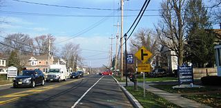
Wayside is an unincorporated community located along the border of Tinton Falls Borough and Ocean Township in Monmouth County, New Jersey, United States. The community is largely residential though some churches, parks, and schools are located in the area. The main arterial roads in the community are Hope Road, Wayside Road, and West Park Avenue. Access to New Jersey Route 18 is available via nearby interchanges with Deal Road, West Park Avenue, and Wayside Road; the Garden State Parkway's exit 105 is also located north of Wayside. The building that once housed the 16-lane Wayside Bowl-O-Drome is still in use, now as an office building.

Spring Lake is a commuter railroad station in the borough of Spring Lake, Monmouth County, New Jersey, United States. Located near the border with Spring Lake Heights, trains are served by New Jersey Transit's North Jersey Coast Line, which serve stations from New York Penn Station, Hoboken Terminal and Long Branch to Bay Head. The next station northward is Belmar, while the next station south is Manasquan. Spring Lake station lacks accessibility for handicapped persons per the Americans With Disabilities Act of 1990.
Parkway Pines is an unincorporated community located along the border of Howell Township in Monmouth County and Brick Township in Ocean County, in New Jersey, United States. The Howell area of this community is called Ramtown.

New Lisbon is an unincorporated community located within Pemberton Township in Burlington County, New Jersey, United States. It is a settlement along Four Mile Road where it intersects Mount Misery Road. The community is located along the Philadelphia and Long Branch Railway, later a part of the Pennsylvania Railroad, and featured a train station.

Holmeson is an unincorporated community located within Millstone Township in Monmouth County, New Jersey, United States. As it is located along County Route 537 through which the Monmouth–Ocean county line runs down the center, portions of the community are also located in Jackson Township. Owing to its location near Interstate 195 and Six Flags Great Adventure, the community is mostly made up of gas stations, restaurants, and small businesses though the Jackson Premium Outlets occupies land just south of the community.

Prospertown is an unincorporated community located within the New Jersey townships of Jackson and Plumsted in Ocean County and Upper Freehold in Monmouth County. The community is home to Prospertown Lake and is adjacent to Six Flags Great Adventure, both located on County Route 537. The center of the community is located at the intersection of CR 537, Hawkin Road, and Emleys Hill Road. Most of the area consists of pine forests but there are some homes along the roads in the area.

Penns Neck is an unincorporated community located within West Windsor Township in Mercer County, New Jersey, United States. The community developed at the intersection of the Trenton-New Brunswick Turnpike and Washington Road. The Penns Neck Circle and the historic Penns Neck Baptist Church (1812) are both located in Penns Neck. The Princeton Branch rail line, known as the Dinky, has run through the area since 1865, and stopped at Penns Neck station until January 1971.

Wheatland is an unincorporated community within Manchester Township in Ocean County, New Jersey, United States.

Branchport is an unincorporated community located within Long Branch in Monmouth County, New Jersey, United States. Centered in the northern part of the city, the area contains mostly single-family homes along grid-like streets though some commercial businesses are located on New Jersey Route 36 which through Branchport is called Joline Avenue. The North Jersey Coast Line passes through the community though the closest stops along the line are the Monmouth Park station in Oceanport and the Long Branch station in the center of the city.

Galilee is an unincorporated community located within Monmouth Beach in Monmouth County, New Jersey, United States. The area is named for the Biblical city of Galilee and was founded as a fishing village. Located at the northern extent of Monmouth Beach, it is located along the peninsula where it begins to greatly narrow between the Shrewsbury River and the Atlantic Ocean. Single family homes typically make up the ocean side of the peninsula while condominiums and a marina are located on the river side. The Sea Bright–Monmouth Beach Seawall passes through the community and continues to neighboring Sea Bright.

Normandie is an unincorporated community located within Sea Bright in Monmouth County, New Jersey, United States. The community is one of the four main built-up areas of Sea Bright and is a former stop on the New Jersey Southern Railroad. It is located along Route 36 between the CR 520 drawbridge to Rumson and Sandy Hook on a narrow strip of land between the Shrewsbury River and the Atlantic Ocean. The Sea Bright–Monmouth Beach Seawall passes through the neighborhood and Navesink Beach.

North Long Branch is an unincorporated community located within Long Branch in Monmouth County, New Jersey, United States. The community is situated in the northern portion of the city and is physically located between Troutmans Creek and Ocean Boulevard. Centered about the intersection of Joline Avenue and Long Branch Avenue, most of the area is made up of single-family houses except for some schools, apartment complexes, and the city's sewage treatment plant.

Ewansville or Ewanville is an unincorporated community located in Burlington County, New Jersey, United States. The community is centered on the crossing of U.S. Route 206 (US 206) and the North Branch Rancocas Creek just north of the former Philadelphia and Long Branch Railway. Ewansville was the site of a station on the aforementioned railroad and was the terminus for a short spur track to Vincentown.

Stonehurst East is an unincorporated community located within the western section of Freehold Township in Monmouth County, New Jersey, United States. The area is mostly made up of a housing development bordered by U.S. Route 9, Schanck Road, Stillwells Corner Road, and County Route 524. The area was farmland until it was developed into homes in the late 1960s.


