Route 156 is a 1.28-mile (2.06 km) long state highway in New Jersey, United States. It is a short connector in Yardville, a census-designated place which is part of Hamilton Township, Mercer County. It is an old two-lane alignment of U.S. Route 130 that was bypassed by a new multi-lane highway a short distance to the east in the 1950s, and designated just before the 1953 renumbering of state highways. The route intersects Route 130 at both termini; it carries local traffic to and from US 130 southbound through Yardville. The route has remained mainly intact since 1953.

Harmony is an unincorporated community located within Jackson Township, in Ocean County, New Jersey, United States.

Raven Rock is an unincorporated community and hamlet along the Delaware River approximately three miles (4.8 km) north of Stockton along New Jersey Route 29. The hamlet was known earlier as Saxtonville. It is located within Delaware Township in Hunterdon County, New Jersey, United States. It is the site of Bull's Island Recreation Area. The rock outcrop for which it is named is the southwest corner of the Hunterdon Plateau.
Route 160 was a short, 0.47-mile (0.76 km) state highway in Bordentown Township, Burlington County, New Jersey, United States. The highway ran along a former alignment of Route 39 and U.S. Route 206 (US 206) called Mission Road in Bordentown Township. The route began at an intersection with US 206, paralleling the four-lane highway to the east and serving local residences before turning to the northwest and serving a strip mall. The highway merged with US 206 further north past an intersection with Hilltop Road.

Tennent is an unincorporated community located within Manalapan Township in Monmouth County, New Jersey, United States. Considered to be the historic center of Manalapan Township, Tennent is home to the Old Tennent Church and Old Tennent Cemetery. William Tennent served as pastor at the church for over 40 years. Tennent was also the center of a historic community of African Americans dating back to the early nineteenth century. The location of Tennent is located at the modern intersection of County Route 522 and Tennent Road and is near the limits of Monmouth Battlefield State Park.

Spring Valley is an unincorporated community located within Marlboro Township in Monmouth County, New Jersey, United States. Located in the northern section of the township, the area is mainly forested with some businesses and cemeteries lining the main roads in the area, Spring Valley Road and Texas Road. U.S. Route 9, Route 18 and County Route 3 are major roads nearby Spring Valley.

East Long Branch is an unincorporated community and neighborhood located within Long Branch in Monmouth County, New Jersey, United States. It is located in the northern portion of the city along the Atlantic Ocean coastline. Major roads through the area include Joline Avenue and Ocean Boulevard, both of which are parts of New Jersey Route 36. Homes consisting of single-family houses and condominiums are located throughout the area and the county-maintained Seven Presidents Park is located within East Long Branch.

Rosemont is an unincorporated community located within Delaware Township in Hunterdon County, New Jersey, United States. Its ZIP code is 08556. Located at the top of a small hill, the center of the community is located along Kingwood Stockton Road near its intersections with Raven Rock Rosemont Road and Rosemont Ringoes Road. Farmland and residences make up the surrounding area while the center of the settlement includes residences, a post office, and an antique shop.

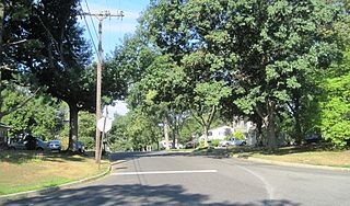
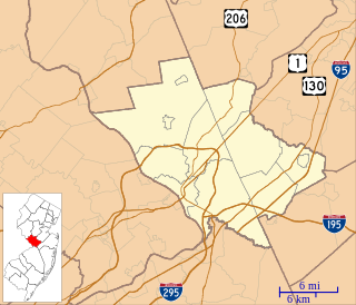
Hickory Corner is an unincorporated community located within East Windsor Township in Mercer County, New Jersey, United States. The area consists of mostly single-family homes constructed in the 1960s but there are some apartment complexes nearby and is the location of the East Windsor Beth El Synagogue.

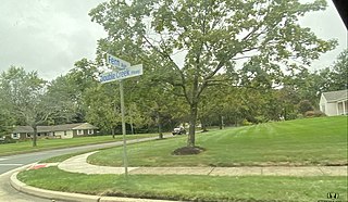
Locust Corner is an unincorporated community located within East Windsor Township in Mercer County, New Jersey, United States. The corner itself refers to the intersection of Princeton-Hightstown Road, County Route 571, and Old Trenton Road, CR 535. To the southeast of the intersection is the western terminus of the Hightstown Bypass, New Jersey Route 133. Much of the area has developed into commercial office spaces including on what was once the site of RCA Astro Electronics' headquarters.
Millstone is an unincorporated community located within East Windsor Township in Mercer County, New Jersey, United States. Located in the northern portion of the township near Old Cranbury Road, U.S. Route 130, and New Jersey Route 133, it is a planned community constructed in the 1960s.

Ackors Corner is an unincorporated community located within Hopewell Township in Mercer County, New Jersey, United States. The settlement is located at the intersection of Bear Tavern Road / Trenton-Harbourton Road, Pennington-Harbourton Road and Pleasant Valley Road. It is named for the Ackors family which owned land near the current intersection. Small residences and farmland make up the area surrounding Ackors Corner but the area rises in elevation from east to west as one approaches Baldpate Mountain, part of the Sourland Mountain range.

Hillside Terrace is an unincorporated community located within Robbinsville Township in Mercer County, New Jersey, United States. The community consists of single-family houses on both sides of Robbinsville-Allentown Road between U.S. Route 130 and the New Jersey Turnpike. The original section of the neighborhood near the intersection of CR 526 and Spring Garden Road was constructed between the late 1950s and the early 1960s. A more modern subdivision was constructed on the southwestern side of CR 526 by 1995 consisting of larger homes.
Lawrence Station is an unincorporated community located within Lawrence Township in Mercer County, New Jersey, United States. The settlement is named for a former railroad station on the Pennsylvania Railroad's New York Division line, now a part of the Northeast Corridor. Today, some wooded areas and buildings from the time of the station remain but more townhouse developments, cultural centers, and industrial facilities are located along the main road through the area, Lawrence Station Road.

Cranbury Station is an unincorporated community located within Cranbury Township in Middlesex County, New Jersey, United States. The area immediately around the site of the former railroad station along the Camden and Amboy Railroad contains agricultural businesses and small homes. Hightstown-Cranbury Station Road is the main road through the settlement paralleling the railroad and Station Road as a major road heading east and west through the area. Modern warehouses line Station Road and the nearby New Jersey Turnpike west of the station while large housing developments are located east of here in Monroe Township.

Sandy Ridge is an unincorporated community located within Delaware Township in Hunterdon County, New Jersey, United States. As its name implies, the community is located at the top of a small hill that is sandwiched between the Hunterdon Plateau and the Sourland Mountains. Sandy Ridge Road is the main road east and west through the community while County Route 605 is a minor arterial road that passes north and south through the area. CR 605 enters from the south on Sandy Ridge-Mt. Airy Road, jogs to the west on Sandy Ridge Road for 0.04 miles (64 m), and exits to the north on Cemetery Road towards CR 523. The area consists of mainly residences with some farmland and forestland. The Sandy Ridge Church is a Baptist church founded in 1818 with its current building constructed in 1866 and is located in the center of Sandy Ridge.

Cooleys Corner is an unincorporated community located within Upper Freehold Township in Monmouth County, New Jersey, United States. The site of the settlement is within the Assunpink Wildlife Management Area, a New Jersey Department of Environmental Protection Division of Fish and Wildlife-operated preserved area in Monmouth and Mercer counties along the Assunpink Creek. Before the creation of the Assunpink Lake in the 1970s, the area consisted of farmland located at the intersection of Clarksburg Road and Imlaystown-Hightstown Road. Some farmland is still present in the area but is now mostly used by hunters. The main boat ramp to Assunpink Lake is located along the former Imlaystown-Hightstown Road.

Kirbys Mills is an unincorporated community located within Upper Freehold Township in Monmouth County, New Jersey, United States. Centered near the intersection of Burlington Path Road and Holmes Mill Road, the area consists of housing developments and small farms.

Morrells Corner or Morrell Corners is an unincorporated community located within Holmdel and Hazlet townships in Monmouth County, New Jersey, United States. The main north–south road through here is Holmdel Road, and the main east–west road is Bethany Road. Most of the area is suburban and consists of homes alongside roads with some businesses and the Hazlet NJ Transit station along the main roads.
Stonehurst West is an unincorporated community located within Freehold Township in Monmouth County, New Jersey, United States. The homes in this community were built in the late 1960s and the early 1970s along County Route 537. The area is situated very close by Monmouth Heights.


