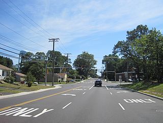
Gordons Corner is an unincorporated community located within Manalapan Township in Monmouth County, New Jersey, United States. The community is centered near the interchange with U.S. Route 9 (US 9), Tennent Road and Gordons Corner Road. Numerous strip malls and businesses line US 9 especially south of the interchange. The surrounding area is mostly made up of older housing developments though some farms are located on the north side of the community.

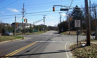
Coxs Corner is an unincorporated community located where the Keith line intersects the Lincoln Highway. The settlement is located in both Lawrence Township and Princeton in Mercer County, New Jersey, United States. The settlement is located where U.S. Route 206 crosses the Keith Line, the former boundary between East and West Jersey. Surrounding the area are homes and small businesses clustered along US 206 and forestland making up the remainder.

Harneys Corner is an unincorporated community located within Lawrence Township in Mercer County, New Jersey, United States. It is located at the intersection of Lawrence Road and Princeton Pike / Avenue. Located in the southern portion of the township close to the Trenton and Ewing borders, the area consists of small houses on nearby side streets and businesses along the aforementioned arterial roads. The intersection itself is located about 0.3 miles (0.48 km) north of the Brunswick Circle.

Coopers Corner is an unincorporated community located within Hopewell Township in Mercer County, New Jersey, United States. The settlement is centered about the intersection of County Routes 518 and 579.

Ackors Corner is an unincorporated community located within Hopewell Township in Mercer County, New Jersey, United States. The settlement is located at the intersection of Bear Tavern Road / Trenton-Harbourton Road, Pennington-Harbourton Road and Pleasant Valley Road. It is named for the Ackors family which owned land near the current intersection. Small residences and farmland make up the area surrounding Ackors Corner but the area rises in elevation from east to west as one approaches Baldpate Mountain, part of the Sourland Mountain range.
Post Corner is an unincorporated community located within West Windsor Township in Mercer County, New Jersey, United States.

Alvater Corner is an unincorporated community located within Franklin Township in Hunterdon County, New Jersey, United States.
Gary Corner is an unincorporated community located within Raritan Township in Hunterdon County, New Jersey, United States.
Mechlings Corner is an unincorporated community located on the border of Alexandria and Union townships in Hunterdon County, New Jersey, United States.
Moerls Corner or Moerle Corner is an unincorporated community located within Old Bridge Township in Middlesex County, New Jersey, United States. The intersection for which the corner is named is at Marlboro Road and Texas Road. The eastern quadrant of the intersection contains condominium units while the other three quadrants are sparsely-populated forest.

Claytons Corner is an unincorporated community located within Marlboro Township in Monmouth County, New Jersey, United States. The community is located along Gordons Corner Road near its intersections with Church Road and Robertsville Road and is completely suburban in nature as the area is part of houses in planned communities. The last remaining farm in Clayton's Corner belonged to the Yoncak family.

Dogs Corners is an unincorporated community in Ocean Township in Monmouth County, New Jersey, United States.

Morrells Corner or Morrell Corners is an unincorporated community located within Holmdel and Hazlet townships in Monmouth County, New Jersey, United States. The main north-south road through here is Holmdel Road and the main east-west road is Bethany Road. Most of the area is suburban and consists of homes alongside roads with some businesses and the Hazlet NJ Transit station along the main roads.

Shacks Corner is an unincorporated community located within Howell Township in Monmouth County, New Jersey, United States. The settlement is located along New Jersey Route 33 at its intersection with Yellow Brook Road. The area to the north of Route 33 is forested and consists entirely of Naval Weapons Station Earle. On the south side of the highway, there are small clusters of homes along Yellow Brook Road and a few other side roads off Route 33. Some businesses also line the southern side of Route 33 in the area.

Smocks Corner or Smocks Corners is an unincorporated community located within Marlboro Township in Monmouth County, New Jersey, United States. Located at the intersection of Pleasant Valley Road and Conover Road, the area is mostly residences with some open space and farmland. It was called "Smocks Corner" because the Smock Family had houses in that area, both sides of the street back in the 1700s.
Tiltons Corner or Tiltons Corners is an unincorporated community located where the municipal boundaries of Keansburg Borough, Hazlet Township and Middletown Township intersect in Monmouth County, New Jersey, United States.

Wertheins Corner is an unincorporated community located within Ocean Township in Monmouth County, New Jersey, United States. The settlement is centered on the intersection of New Jersey Route 35 and Deal Road in the center part of the township. Commercial businesses line Route 35 through the area. On the west side of Route 35, there are some apartment and townhouse complexes while single-family houses are located on the east side of the highway.
Wileys Corner or Wileys Corners is an unincorporated community located within Tinton Falls in Monmouth County, New Jersey, United States.
Chambers Corner or Chambers Corners is an unincorporated community located within Springfield Township in Burlington County, New Jersey, United States. The intersection defining the community is the junction of Monmouth Road and U.S. Route 206. Juliustown Road runs to the south of the settlement and terminates at CR 537. Except for some stores and businesses that line US 206 and some single-family homes along CR 537, the area is mostly made up of farmland.

Vanlieu Corners is an unincorporated community in East Amwell Township in Hunterdon County, New Jersey, United States.