
Holmdel Dutch Reformed Church is a historic church at 41 Main Street in Holmdel Township, Monmouth County, New Jersey, United States.

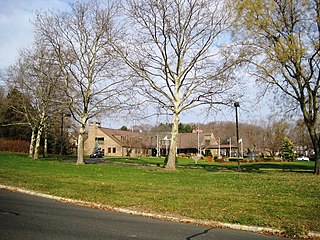
Pleasant Valley Crossroads is an unincorporated community located within Holmdel Township in Monmouth County, New Jersey, United States. Route 34 and County Route 520 are major roads in this area.

Texas is an unincorporated community located along the border of Monroe and Old Bridge townships in Middlesex County, New Jersey, United States. The two townships, split by the Matchaponix Brook, consist of similar land uses. Both have a mix of housing developments and forest land in the vicinity of the community. The main road that runs east and west through the community is Texas Road; it connects to County Route 520 towards the east and CR 612 on the west via Matchaponix Avenue. Other nearby roads in the vicinity include CR 527, CR 613, U.S. Route 9, and Route 18.

Centerville is an unincorporated community located within Hopewell Township in Mercer County, New Jersey, United States. The community is located at the intersection of Pennington-Rocky Hill Road and Titus Mill Road. Bristol-Myers Squibb's Hopewell Campus is located in Centerville.

East Spotswood, also known as the settlement of Old Bridge, is an unincorporated community located within East Brunswick, New Jersey and Old Bridge townships in Middlesex County, New Jersey, United States. The area is made up of homes, businesses, and wetlands for the South River. The area is located at the junction of New Jersey Route 18, County Route 527, the western end of CR 516, and the Bordentown and South Amboy Turnpike. The still-active Jamesburg Branch of the former Camden & Amboy Railroad also runs through the community.

Orchard Heights is an unincorporated community located within East Brunswick Township in Middlesex County, New Jersey, United States. The area is part of a suburban residential neighborhood near the Cranbury Road interchange with New Jersey Route 18. Near the area includes two schools, churches, and St. Mary's Cemetery.

South Old Bridge is an unincorporated community located within Old Bridge Township in Middlesex County, New Jersey, United States. The community consists of homes and businesses between New Jersey Route 18 and County Route 516 in the western portion of the township. The reason for the odd directional naming is because it is located south of the settlement of Old Bridge while the name of the township of the time was Madison Township.

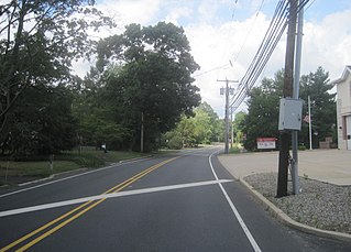
Everett is an unincorporated community located along the border of Holmdel and Middletown townships in Monmouth County, New Jersey, United States. The community is located on Everett Road, along which the township line runs, at its intersection with Stillwell Road and Sunnyside Road. Most of the area in Everett is composed of homes with some farmlands nearby. Holmdel's Bell Labs Complex is located to the west of Everett.
Crawford Corners or Crawfords Corner is an unincorporated community located within Holmdel Township in Monmouth County, New Jersey, United States. The settlement is located at the intersection of Holmdel Road and Crawfords Corners Road in the hilly northern portion of the township. The settlement is located about one-half mile (0.80 km) from Crawford Hill, the highest point in Monmouth County. The area also includes the township's town hall, police department, and high school in addition to a New Jersey State Police barracks and the PNC Bank Arts Center off the Garden State Parkway. These buildings and landmarks comprise the eastern section of the settlement, homes and heavily treed lands are located on the west side of Holmdel Road, and Holmdel Park makes up the southern portion of the area.
Glendola is an unincorporated community located within Wall Township in Monmouth County, New Jersey, United States. It is the location of the Glendola Reservoir. Most of the area consists of single-family residences along numerous streets throughout the settlement. The main east-west road through Glendola is Belmar Boulevard while access to the nearby Route 18 freeway is provided via Brighton Avenue.

Hendrickson Corners is an unincorporated community located along the border of Holmdel and Middletown townships in Monmouth County, New Jersey, United States. The area primarily consists of commercial businesses along the Route 35 corridor; also nearby are an apartment complex and houses in developments throughout. County Route 516 has a brief concurrency with Route 35 in Hendricksons Corners; the easternmost intersection of the two roads is where the settlement is centered.
Holland is an unincorporated community located on the border of Holmdel and Middletown townships in Monmouth County, New Jersey, United States. The community is centered on the intersection of County Route 52 and Holland Road. The area making up Holland is hilly and consists of large single-family residences. An AT&T Labs campus is located off Laurel Avenue while Tatum County Park is also located in the area, both of which are on the Middletown side of the border.

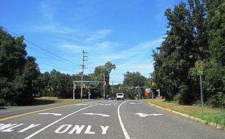
Macedonia is an unincorporated community located within Tinton Falls in Monmouth County, New Jersey, United States. The settlement, found in the center of Tinton Falls, is located near the interchange complex between the Garden State Parkway, New Jersey Route 18, New Jersey Route 36, and Wayside Road. The main residential section of the community is located just north of Route 18 and consists of smaller single-family houses, churches, a fire department, and a park. On the south side of Route 18, an asphalt production plant and Naval Weapons Station Earle make up the landscape.

Morrells Corner or Morrell Corners is an unincorporated community located within Holmdel and Hazlet townships in Monmouth County, New Jersey, United States. The main north-south road through here is Holmdel Road and the main east-west road is Bethany Road. Most of the area is suburban and consists of homes alongside roads with some businesses and the Hazlet NJ Transit station along the main roads.
North Centerville is an unincorporated community located within Hazlet Township in Monmouth County, New Jersey, United States. Like most of Hazlet, North Centerville is largely suburban. The settlement is located at the intersection of Middle Road and Union Avenue in the center of the township.

Philips Mills or Philip Mills is an unincorporated community located along the border of Holmdel and Middletown townships in Monmouth County, New Jersey, United States. It is located about the intersection of Palmer Avenue and Middle Road and Main Street. Around the area, some small businesses are located along the main arterial roads; single-family houses dot the area mostly towards the east side of the community. Throughout most of the west side, wooded areas lining the Waackaack Creek are found.

Pullentown is an unincorporated community located within Upper Freehold Township in Monmouth County, New Jersey, United States. The settlement is located along County Route 526 east of Allentown and just west of its intersection with Sharon Station Road. The area contains mostly farmland with some homes and small businesses located along the road.


