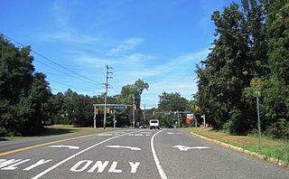
Route 36 is a state highway in Monmouth County, New Jersey, United States. The 24.40-mile (39.27 km) long route, shaped as a backwards C, begins at an intersection with Garden State Parkway and County Route 51 in Eatontown and runs east to Long Branch. From Long Branch, the route follows the Atlantic Ocean north to Sea Bright and turns west, running to the south of the Raritan Bay. Route 36 ends in Keyport at an interchange with the Garden State Parkway and Route 35. It varies in width from a six-lane divided highway to a two-lane undivided road. The route is signed east–west between Eatontown and Long Branch and north–south between Long Branch and Keyport.

Monmouth Beach is a borough in Monmouth County, New Jersey, United States. As of the 2010 United States Census, the borough's population was 3,279, reflecting a decline of 316 (-8.8%) from the 3,595 counted in the 2000 Census, which had in turn increased by 292 (+8.8%) from the 3,303 counted in the 1990 Census.
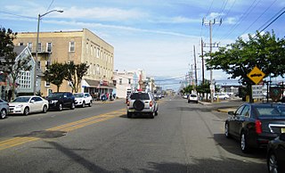
Sea Bright is a borough in Monmouth County, New Jersey, United States. As of the 2010 United States Census, the borough's population was 1,412, reflecting a decline of 406 (-22.3%) from the 1,818 counted in the 2000 Census, which had in turn increased by 125 (+7.4%) from the 1,693 counted in the 1990 Census.

Parkway Pines is an unincorporated community located along the border of Howell Township in Monmouth County and Brick Township in Ocean County, in New Jersey, United States. The Howell area of this community is called Ramtown.

Spring Valley is an unincorporated community located within Marlboro Township in Monmouth County, New Jersey, United States. Located in the northern section of the township, the area is mainly forested with some businesses and cemeteries lining the main roads in the area, Spring Valley Road and Texas Road. U.S. Route 9, Route 18 and County Route 3 are major roads nearby Spring Valley.

Prospertown is an unincorporated community located within the New Jersey townships of Jackson and Plumsted in Ocean County and Upper Freehold in Monmouth County. The community is home to Prospertown Lake and is adjacent to Six Flags Great Adventure, both located on County Route 537. The center of the community is located at the intersection of CR 537, Hawkin Road, and Emleys Hill Road. Most of the area consists of pine forests but there are some homes along the roads in the area.

East Long Branch is an unincorporated community and neighborhood located within Long Branch in Monmouth County, New Jersey, United States. It is located in the northern portion of the city along the Atlantic Ocean coastline. Major roads through the area include Joline Avenue and Ocean Boulevard, both of which are parts of New Jersey Route 36. Homes consisting of single-family houses and condominiums are located throughout the area and the county-maintained Seven Presidents Park is located within East Long Branch.

Gordons Corner is an unincorporated community located within Manalapan Township in Monmouth County, New Jersey, United States. The community is centered near the interchange with U.S. Route 9 (US 9), Tennent Road and Gordons Corner Road. Numerous strip malls and businesses line US 9 especially south of the interchange. The surrounding area is mostly made up of older housing developments though some farms are located on the north side of the community.
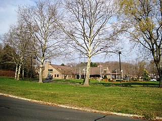
Crawford Corners or Crawfords Corner is an unincorporated community located within Holmdel Township in Monmouth County, New Jersey, United States. The settlement is located at the intersection of Holmdel Road and Crawfords Corners Road in the hilly northern portion of the township. The settlement is located about one-half mile (0.80 km) from Crawford Hill, the highest point in Monmouth County. The area also includes the township's town hall, police department, and high school in addition to a New Jersey State Police barracks and the PNC Bank Arts Center off the Garden State Parkway. These buildings and landmarks comprise the eastern section of the settlement, homes and heavily treed lands are located on the west side of Holmdel Road, and Holmdel Park makes up the southern portion of the area.

Fort Plains is an unincorporated community located within Howell Township in Monmouth County, New Jersey, United States. The settlement is centered about the intersection of Fort Plains Road and West Farms Road on the western side of the township. Nearby the intersection are numerous housing developments consisting of larger single-family houses. U.S. Route 9 also runs north and south where numerous commercial businesses are found. The remainder of the area consists of forestland.

Galilee is an unincorporated community located within Monmouth Beach in Monmouth County, New Jersey, United States. The area is named for the Biblical city of Galilee and was founded as a fishing village. Located at the northern extent of Monmouth Beach, it is located along the peninsula where it begins to greatly narrow between the Shrewsbury River and the Atlantic Ocean. Single family homes typically make up the ocean side of the peninsula while condominiums and a marina are located on the river side. The Sea Bright–Monmouth Beach Seawall passes through the community and continues to neighboring Sea Bright.
Holland is an unincorporated community located on the border of Holmdel and Middletown townships in Monmouth County, New Jersey, United States. The community is centered on the intersection of County Route 52 and Holland Road. The area making up Holland is hilly and consists of large single-family residences. An AT&T Labs campus is located off Laurel Avenue while Tatum County Park is also located in the area, both of which are on the Middletown side of the border.

Matthews is an unincorporated community located within Howell Township in Monmouth County, New Jersey, United States. The settlement is located on the western border of the township near Jackson Township, Ocean County and Interstate 195. It is located about the intersection of Hulses Corner Road and Fort Plains Road. The Howell side of the North Branch Metedeconk River is mainly rural with only a few houses located along the main surface roads while the Jackson side of the river is more suburbanized.

Navesink Beach is an unincorporated community located within Sea Bright in Monmouth County, New Jersey, United States. It is one of the four main built-up areas of Sea Bright and is the northernmost settled area of the borough. Navesink Beach is a former stop on the New Jersey Southern Railroad. The Sea Bright–Monmouth Beach Seawall passes through the neighborhood and Normandie.

Normandie is an unincorporated community located within Sea Bright in Monmouth County, New Jersey, United States. The community is one of the four main built-up areas of Sea Bright and is a former stop on the New Jersey Southern Railroad. It is located along Route 36 between the CR 520 drawbridge to Rumson and Sandy Hook on a narrow strip of land between the Shrewsbury River and the Atlantic Ocean. The Sea Bright–Monmouth Beach Seawall passes through the neighborhood and Navesink Beach.

Philips Mills or Philip Mills is an unincorporated community located along the border of Holmdel and Middletown townships in Monmouth County, New Jersey, United States. It is located about the intersection of Palmer Avenue and Middle Road and Main Street. Around the area, some small businesses are located along the main arterial roads; single-family houses dot the area mostly towards the east side of the community. Throughout most of the west side, wooded areas lining the Waackaack Creek are found.

Shacks Corner is an unincorporated community located within Howell Township in Monmouth County, New Jersey, United States. The settlement is located along New Jersey Route 33 at its intersection with Yellow Brook Road. The area to the north of Route 33 is forested and consists entirely of Naval Weapons Station Earle. On the south side of the highway, there are small clusters of homes along Yellow Brook Road and a few other side roads off Route 33. Some businesses also line the southern side of Route 33 in the area.

Smocks Corner or Smocks Corners is an unincorporated community located within Marlboro Township in Monmouth County, New Jersey, United States. Located at the intersection of Pleasant Valley Road and Conover Road, the area is mostly residences with some open space and farmland. It was called "Smocks Corner" because the Smock Family had houses in that area, both sides of the street back in the 1700s.

Wertheins Corner is an unincorporated community located within Ocean Township in Monmouth County, New Jersey, United States. The settlement is centered on the intersection of New Jersey Route 35 and Deal Road in the center part of the township. Commercial businesses line Route 35 through the area. On the west side of Route 35, there are some apartment and townhouse complexes while single-family houses are located on the east side of the highway.
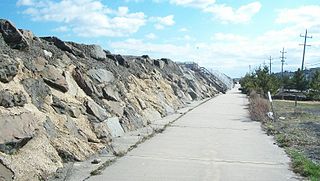
The Sea Bright–Monmouth Beach Seawall is a seawall located along the Jersey Shore in the Monmouth County, New Jersey towns of Sea Bright and Monmouth Beach. It roughly runs north-south direction along 4.7 miles (7.6 km) of the barrier spit of land along the lower Sandy Hook peninsula between the Atlantic Ocean and the Shrewsbury River estuary. The use of seawalls, groins, jetties, bulkheads, revetment, and beach nourishment since the late 1800s has made the stretch of coast one of the most heavily engineered sections of ocean shorefront in the world.


