
Englishtown is a borough in Monmouth County, New Jersey, United States. The community is nestled within the Raritan Valley region. As of the 2010 United States Census, the borough's population was 1,847, reflecting an increase of 83 (+4.7%) from the 1,764 counted in the 2000 Census, which had in turn increased by 496 (+39.1%) from the 1,268 counted in the 1990 Census.
Manalapan Township is a township in Monmouth County, New Jersey, United States. The township is centrally located within the Raritan Valley region and is a part of the New York Metropolitan Area. As of the 2010 United States Census, the township's population was 38,872, representing an increase of 5,449 (+16.3%) from the 33,423 counted in the 2000 Census, which had in turn increased by 6,707 (+25.1%) from the 26,716 counted in the 1990 Census.
Marlboro is an unincorporated community located within Marlboro Township in Monmouth County, New Jersey, United States.
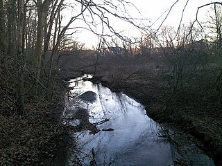
Manalapan Brook is a tributary of the South River in Monmouth and Middlesex counties, New Jersey in the United States.
The Manalapan-Englishtown Regional School District is a regional public school district serving students in pre-kindergarten through eighth grade from the suburban communities of Englishtown and Manalapan Township in Monmouth County, New Jersey, United States.
Deans is an unincorporated community located within South Brunswick Township in Middlesex County, New Jersey, United States.

Perrineville is an unincorporated community located within Millstone Township in Monmouth County, New Jersey, United States. The area is served as United States Postal Service ZIP code 08535.

Tennent is an unincorporated community located within Manalapan Township in Monmouth County, New Jersey, United States. Considered to be the historic center of Manalapan Township, Tennent is home to the Old Tennent Church and Old Tennent Cemetery. William Tennent served as pastor at the church for over 40 years. Tennent was also the center of a historic community of African Americans dating back to the early nineteenth century. The location of Tennent is located at the modern intersection of County Route 522 and Tennent Road and is near the limits of Monmouth Battlefield State Park.

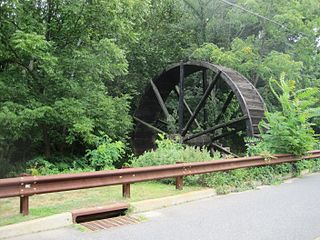
Millhurst is an unincorporated community located within Manalapan Township in Monmouth County, New Jersey, United States. Route 33 and County Route 527 pass through the center of Millhurst. Much of the area consists of businesses along the aforementioned arterial roads with the Millhurst Mill at the CR 527 crossing of Manalapan Brook. The mill is a former grist mill built in the 1700s, rebuilt in the 1800s as a more efficient mill, and turned into a family business by Bernard Hochberg in 1925.
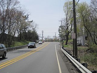
Smithburg is an unincorporated community located where the municipal boundaries of Freehold, Manalapan and Millstone townships intersect in Monmouth County, New Jersey, United States. County Route 527 and Monmouth Road pass through the center of the quaint village of Smithburg.

Jerseyville is an unincorporated community located within Howell Township in Monmouth County, New Jersey, United States. It is primarily a rural area within the northern part of the township, near Colts Neck and Freehold. Route 33 Business travels through Jerseyville, with some development, including a gas station, a convenience store, a church, and several residences.
Bucks Mill is an unincorporated community located within Colts Neck Township, in Monmouth County, New Jersey, United States. Bucks Mill Road is the main road that passes north and south through the area; County Route 537 travels to the south of Bucks Mill, near the Hominy Hill Golf Course. Homes, equestrian facility and horse farms, and the township-owned Bucks Mill Recreational Area are located in the area. The settlement is named for Bucks Mill, a gristmill that derived its power from a watermill on the Yellow Brook. Originally built in 1854 and owned for many years by William Buck, Alfred Buck, and Garrett Buck, it was destroyed by a fire on October 30, 1967. The watermill is the only remaining artifact of the original complex and stands today on the side of Bucks Mill Road.

Burrs Mill is an unincorporated community located within Southampton Township in Burlington County, New Jersey, United States. Found in a rural portion of the township near Route 70, it is located along its eponymous brook in a forested area within the Pine Barrens. A low density of houses surround nearby roads including Burrs Mill Road and Route 70's fire roads.
Carsons Mills is an unincorporated community located within Robbinsville Township in Mercer County, New Jersey, United States. The community is located at the junctions of the Assunpink Creek and the New Sharon Branch creek and Sharon Road and Windsor Road southeast of the New Jersey Turnpike. Developed areas nearby include small residences and farmland while the undeveloped areas are forest and floodplains as a part of the Assunpink Wildlife Management Area.

Hoffman is an unincorporated community located within Monroe Township in Middlesex County, New Jersey, United States. The settlement is located at the site of a former railroad station on the Freehold and Jamesburg Agricultural Railroad. Today, most of the area is made up of homes and housing developments along Hoffman Station Road and Gravel Hill-Spotswood Road. Forestland and the Manalapan Brook valley make up the remainder of the area.

Rockefellows Mills is an unincorporated community located within Raritan Township in Hunterdon County, New Jersey, United States. The settlement is located along the South Branch Raritan River near Three Bridges. The river is spanned in the area by the historic Rockafellows Mill Bridge built in 1900 and part of the Raritan–Readington South Branch Historic District. Most of the area within the Raritan Township side of the river is forested however on the north side of the river in Readington Township, some farmland dots the area.

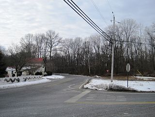
Charleston Springs is an unincorporated community located within Millstone Township in Monmouth County, New Jersey, United States. Stage Coach Road, also designated County Route 524, is the main road that runs through the settlement, with Ely Harmony Road as the intersecting road defining the locality. The Manalapan Brook runs to the west of the center of Charleston Springs and CR 537 runs to the south of the area. The Monmouth County-owned Charleston Springs Golf Course is located one mile (1.6 km) northeast of the center of Charleston Springs on CR 527.

Kirbys Mills is an unincorporated community located within Upper Freehold Township in Monmouth County, New Jersey, United States. Centered near the intersection of Burlington Path Road and Holmes Mill Road, the area consists of housing developments and small farms.

Monmouth Heights at Manalapan is an unincorporated community located within Manalapan Township in Monmouth County, New Jersey, United States. Levitt & Sons developed the Monmouth Heights section from 1965–1969. Residents of the 685 homes in the development are required to join the Monmouth Heights Community Association, which provides pools and other amenities.

Dunns Mill or Dunns Mills is an unincorporated community located within Bordentown Township in Burlington County, New Jersey, United States. The site is named for a gristmill established in 1708 that is located near the settlement along Blacks Creek. Martin Luther Dunn purchased the mill in 1875 but burned down in 1901. The site is presently located near the crossing of the New Jersey Turnpike over County Route 545. A mix of housing developments and preserved open space are located around Dunns Mill today.


