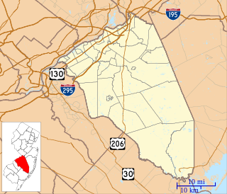
Monmouth County is a county located on the coast of New Jersey, in the United States within the New York metropolitan area, and the northernmost county along the Jersey Shore. As of the 2019 Census estimate, the county's population was 618,795, making it the state's fifth-most populous county, representing a decrease of 0.6% from the 2010 Census, when the population was enumerated at 630,380, in turn an increase of 15,079 from 615,301 at the 2000 Census. As of 2010, the county fell to the fifth-most populous county in the state, having been surpassed by Hudson County. Its county seat is Freehold Borough. The most populous place was Middletown Township, with 66,522 residents at the time of the 2010 Census, while Howell Township covered 61.21 square miles (158.5 km2), the largest total area of any municipality.

Aberdeen Township is a township in Monmouth County, New Jersey, United States. The township is located within the Raritan Valley region and is a part of the New York Metropolitan Area. As of the 2010 United States Census, the township's population was 18,210, reflecting an increase of 756 (+4.3%) from the 17,454 counted in the 2000 Census, which had in turn increased by 416 (+2.4%) from the 17,038 counted in the 1990 Census.
Hazlet is a township in Monmouth County, New Jersey, United States. The borough is located near the Raritan Bay within the Raritan Valley region. It is located in the New York Metropolitan Area and is a bedroom community of New York. As of the 2010 United States Census, the township's population was 20,334, reflecting a decline of 1,044 (-4.9%) from the 21,378 counted in the 2000 Census, which had in turn declined by 598 (-2.7%) from the 21,976 counted in the 1990 Census.

Holmdel Township is a township in Monmouth County, New Jersey, United States. The township is centrally located in the Raritan Valley region, being within the regional and cultural influence of the Raritan Bayshore. It is located in the New York Metropolitan Area and is a major bedroom community of New York City. As of the 2010 United States Census, the township's population was 16,773, reflecting an increase of 992 (+6.3%) from the 15,781 counted in the 2000 Census, which had in turn increased by 4,249 (+36.8%) from the 11,532 counted in the 1990 Census.

Siloam is an unincorporated community located within Freehold Township in Monmouth County, New Jersey, United States. Siloam was once the site of a school serving a district in the township until 1936. County Route 527 passes through the center of Siloam. Exit 21 on Interstate 195 provides access to Siloam from the south. Except around the center of the settlement at the junction of CR 527 and Ely Harmony Road, the area consists of forests comprising the northernmost reaches of the Pine Barrens. The homes in the area are smaller in size and are found only along the aforementioned roads.

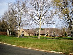
Pleasant Valley Crossroads is an unincorporated community located within Holmdel Township in Monmouth County, New Jersey, United States. Route 34 and County Route 520 are major roads in this area.

Prospertown is an unincorporated community located within the New Jersey townships of Jackson and Plumsted in Ocean County and Upper Freehold in Monmouth County. The community is home to Prospertown Lake and is adjacent to Six Flags Great Adventure, both located on County Route 537. The center of the community is located at the intersection of CR 537, Hawkin Road, and Emleys Hill Road. Most of the area consists of pine forests but there are some homes along the roads in the area.

Harneys Corner is an unincorporated community located within Lawrence Township in Mercer County, New Jersey, United States. It is located at the intersection of Lawrence Road and Princeton Pike / Avenue. Located in the southern portion of the township close to the Trenton and Ewing borders, the area consists of small houses on nearby side streets and businesses along the aforementioned arterial roads. The intersection itself is located about 0.3 miles (0.48 km) north of the Brunswick Circle.

Emleys Hill is an unincorporated community located within Upper Freehold Township in Monmouth County, New Jersey, United States. The settlement is located at the intersection of Emleys Hill Road and Burlington Path Road.

Charleston Springs is an unincorporated community located within Millstone Township in Monmouth County, New Jersey, United States. Stage Coach Road, also designated County Route 524, is the main road that runs through the settlement, with Ely Harmony Road as the intersecting road defining the locality. The Manalapan Brook runs to the west of the center of Charleston Springs and CR 537 runs to the south of the area. The Monmouth County-owned Charleston Springs Golf Course is located one mile (1.6 km) northeast of the center of Charleston Springs on CR 527.

Cooleys Corner is an unincorporated community located within Upper Freehold Township in Monmouth County, New Jersey, United States. The site of the settlement is within the Assunpink Wildlife Management Area, a New Jersey Department of Environmental Protection Division of Fish and Wildlife-operated preserved area in Monmouth and Mercer counties along the Assunpink Creek. Before the creation of the Assunpink Lake in the 1970s, the area consisted of farmland located at the intersection of Clarksburg Road and Imlaystown-Hightstown Road. Some farmland is still present in the area but is now mostly used by hunters. The main boat ramp to Assunpink Lake is located along the former Imlaystown-Hightstown Road.

Ely is an unincorporated community located within Millstone Township in Monmouth County, New Jersey, United States. The settlement is named for the Ely family that owned property in the area and operated the Charleston Springs hotel. Today, the settlement is located along Stage Coach Road, County Route 524, in the eastern portion of the township. Most of the area consists of large single-family homes though some farmland and the township-owned Brandywine Soccer Complex are located in the near the settlement.

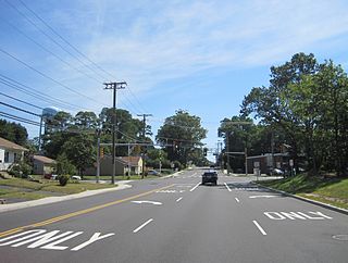
Morrells Corner or Morrell Corners is an unincorporated community located within Holmdel and Hazlet townships in Monmouth County, New Jersey, United States. The main north–south road through here is Holmdel Road, and the main east–west road is Bethany Road. Most of the area is suburban and consists of homes alongside roads with some businesses and the Hazlet NJ Transit station along the main roads.

Mount Pleasant is an unincorporated community located within Marlboro Township in Monmouth County, New Jersey, United States. It is named for a hill of the same name, one of the highest points in Marlboro Township. The settlement is located at the intersection of Reids Hill Road and Beacon Hill Road.

Pleasant Valley is an unincorporated community located within Marlboro Township in Monmouth County, New Jersey, United States. The area reportedly received its name from George Washington after he went through the area in 1777. The area is hilly and forested and is dotted by medium to large-sized residences. Pleasant Valley Road and Reids Hill Road are main roads that pass through the area connecting to Routes 34, 79, and 520. A large part of land which makes up Pleasant Valley was originally granted by the King of England in 1665 to the Rev. Obadiah Holmes. In 1690, the area was settled by people of Dutch heritage and the original dominant language in the area was Low Dutch.

Sharon is an unincorporated community located within Upper Freehold Township in Monmouth County, New Jersey, United States. Located at the intersection of Herbert Road and Sharon Station Road, the settlement is the site of a former stop on the Pemberton and Hightstown Railroad. Except for a few single-family homes in the area, most of the area is farmland. The railroad has since been abandoned and is being converted to the Union Transportation Trail, a rail trail. Sharon is the current northern terminus of the trail.

Smocks Corner or Smocks Corners is an unincorporated community located within Marlboro Township in Monmouth County, New Jersey, United States. Located at the intersection of Pleasant Valley Road and Conover Road, the area is mostly residences with some open space and farmland. It was called "Smocks Corner" because the Smock Family had houses in that area, both sides of the street back in the 1700s.

Spring Mill is an unincorporated community located within Upper Freehold Township in Monmouth County, New Jersey, United States. The settlement is located along County Route 524 between Hamilton Township and Allentown on a commercialized segment of the road originally built as New Jersey Route 37. A vestige of the state construction remains along the road through a wide right-of-way and a bridge crossing Doctor's Creek stating that it was constructed by the state in 1940 for State Highway Route 37.
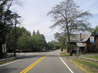
Stone Church is an unincorporated community located in Middletown Township in Monmouth County, New Jersey, United States, within the census-designated place of Navesink. The settlement is located at the intersection of Valley Road and Locust Avenue, Navesink Avenue, and Monmouth Avenue. In the center of the community, the historic All Saint's Memorial Episcopal Church built in 1864 sits at the main intersection. The remainder of the area consists of single-family houses and forests on the slopes of nearby Mount Mitchill.
Chambers Corner or Chambers Corners is an unincorporated community located within Springfield Township in Burlington County, New Jersey, United States. The intersection defining the community is the junction of Monmouth Road and U.S. Route 206. Juliustown Road runs to the south of the settlement and terminates at CR 537. Except for some stores and businesses that line US 206 and some single-family homes along CR 537, the area is mostly made up of farmland.