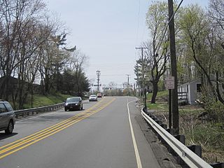
Route 36 is a state highway in Monmouth County, New Jersey, United States. The 24.40-mile (39.27 km) long route, shaped as a backwards C, begins at an intersection with Garden State Parkway and County Route 51 in Eatontown and runs east to Long Branch. From Long Branch, the route follows the Atlantic Ocean north to Sea Bright and turns west, running to the south of the Raritan Bay. Route 36 ends in Keyport at an interchange with the Garden State Parkway and Route 35. It varies in width from a six-lane divided highway to a two-lane undivided road. The route is signed east–west between Eatontown and Long Branch and north–south between Long Branch and Keyport.

Long Branch is a beachside city in Monmouth County, New Jersey, United States. As of the 2010 United States Census, the city's population was 30,719, reflecting a decline of 621 (-2.0%) from the 31,340 counted in the 2000 Census, which had in turn increased by 2,682 (+9.4%) from the 28,658 counted in the 1990 Census.

Oceanport is a borough in Monmouth County, New Jersey, United States. As of the 2010 United States Census, the borough's population was 5,832, reflecting an increase of 25 (+0.4%) from the 5,807 counted in the 2000 Census, which had in turn declined by 339 (-5.5%) from the 6,146 counted in the 1990 Census.

West Long Branch is a borough in Monmouth County, New Jersey, United States. As of the 2010 United States Census, the borough's population was 8,097, reflecting a decline of 161 (-1.9%) from the 8,258 counted in the 2000 Census, which had in turn increased by 568 (+7.4%) from the 7,690 counted in the 1990 Census. It is the home of Monmouth University.
Route 71 is a state highway in New Jersey, United States, running 16.78 miles (27.00 km) near the shore in Monmouth County. It begins at Route 35 in Brielle, just north of the Manasquan River and the Ocean County line, and heads north to Route 35 in Eatontown, with a four-block concurrency with Route 35 in Belmar. Monmouth University is located off Route 71 in West Long Branch.

Central Jersey is the central region of the U.S. state of New Jersey. The designation of Central New Jersey with a distinct toponym is a colloquial one rather than an administrative one.

Middletown is a passenger railway station for New Jersey Transit's North Jersey Coast Line in Middletown Township, Monmouth County, New Jersey. Located along both sides of Church Street in Middletown, the station is the only active station within the township. The station depot contains two high-level platforms for Americans With Disabilities Act of 1990 compliance, four ticket vending machines and 1,616 parking spaces among two lots, 28 of which are handicap accessible.

Elberon is a railway station in the Elberon section of Long Branch, Monmouth County, New Jersey, United States. The station is served by New Jersey Transit's North Jersey Coast Line. Located at the intersection of Lincoln Avenue and Truax Road, It is the first station south of the electrified section of the line. The station has two side level high-level platforms and 229 parking spaces for commuter use.

Holmeson is an unincorporated community located within Millstone Township in Monmouth County, New Jersey, United States. As it is located along County Route 537 through which the Monmouth–Ocean county line runs down the center, portions of the community are also located in Jackson Township. Owing to its location near Interstate 195 and Six Flags Great Adventure, the community is mostly made up of gas stations, restaurants, and small businesses though the Jackson Premium Outlets occupies land just south of the community.

Smithburg is an unincorporated community located where the municipal boundaries of Freehold, Manalapan and Millstone townships intersect in Monmouth County, New Jersey, United States. County Route 527 and Monmouth Road pass through the center of the quaint village of Smithburg.

Hornerstown is an unincorporated community located within Upper Freehold Township in Monmouth County, New Jersey, United States. Hornerstown is located near Cream Ridge and uses the 08514 ZIP code.

East Long Branch is an unincorporated community and neighborhood located within Long Branch in Monmouth County, New Jersey, United States. It is located in the northern portion of the city along the Atlantic Ocean coastline. Major roads through the area include Joline Avenue and Ocean Boulevard, both of which are parts of New Jersey Route 36. Homes consisting of single-family houses and condominiums are located throughout the area and the county-maintained Seven Presidents Park is located within East Long Branch.

New Sharon is an unincorporated community located along the border of Robbinsville Township in Mercer County and Upper Freehold Township in Monmouth County, New Jersey, United States. Old York Road passes through the center of the community.

Bergerville is an unincorporated community located within Howell Township in Monmouth County, New Jersey, United States. The area was originally developed as a resort bungalow community in the first half of the 20th century.

Freewood Acres is an unincorporated community located within Howell Township in Monmouth County, New Jersey, United States. The area is made up of mostly single-story homes arranged along a street grid in the northern reaches of the Pine Barrens. U.S. Route 9 runs through the center of the community just north of its interchange with Interstate 195. The Land O'Pines Elementary School and Manasquan Reservoir County Park exist to the east of the community. It became the center of the Kalmyk American community in the latter part of the 20th century.

Galilee is an unincorporated community located within Monmouth Beach in Monmouth County, New Jersey, United States. The area is named for the Biblical city of Galilee and was founded as a fishing village. Located at the northern extent of Monmouth Beach, it is located along the peninsula where it begins to greatly narrow between the Shrewsbury River and the Atlantic Ocean. Single family homes typically make up the ocean side of the peninsula while condominiums and a marina are located on the river side. The Sea Bright–Monmouth Beach Seawall passes through the community and continues to neighboring Sea Bright.

Monmouth Heights at Marlboro is an unincorporated community located within Marlboro Township in Monmouth County, New Jersey, United States. The housing development was created in the 1960s by Levitt & Sons though some protests occurred by long-time residents of Marlboro Township at the time of its creation. The community is located along New Jersey Route 79 across the highway from Marlboro High School.

Morrells Corner or Morrell Corners is an unincorporated community located within Holmdel and Hazlet townships in Monmouth County, New Jersey, United States. The main north–south road through here is Holmdel Road, and the main east–west road is Bethany Road. Most of the area is suburban and consists of homes alongside roads with some businesses and the Hazlet NJ Transit station along the main roads.

North Long Branch is an unincorporated community located within Long Branch in Monmouth County, New Jersey, United States. The community is situated in the northern portion of the city and is physically located between Troutmans Creek and Ocean Boulevard. Centered about the intersection of Joline Avenue and Long Branch Avenue, most of the area is made up of single-family houses except for some schools, apartment complexes, and the city's sewage treatment plant.

Ellisdale is an unincorporated community located along the border of North Hanover Township in Burlington County and Upper Freehold Township in Monmouth County, in New Jersey, United States. The community is centered about the intersection of Province Line Road and Hill Road / Ellisdale-Crosswicks Road. The Crosswicks Creek runs to the north of the settlement and the nearby Ellisdale Fossil Site takes its name from Ellisdale.


