
Monmouth County is a county located on the coast of central New Jersey, in the United States within the New York metropolitan area, situated along the northern half of the Jersey Shore. As of the 2020 United States Census, Monmouth County's population was enumerated at 643,615, making it the state's fifth-most populous county, representing an increase of 13,245 (2.1%) from the 2010 Census, when the population was counted to be 630,380, in turn an increase of 15,079 from 615,301 at the 2000 Census. As of 2010, the county fell to the fifth-most populous county in the state, having been surpassed by Hudson County. Monmouth County's geographic area comprises 30% water, with a trend toward more expensive homes being constructed along the Shore, bringing rapid gentrification to the county overall.
Route 36 is a state highway in Monmouth County, New Jersey, United States. The 24.40-mile (39.27 km) long route, shaped as a backwards C, begins at an intersection with the Garden State Parkway and County Route 51 on the border of Tinton Falls and Eatontown and runs east to Long Branch. From Long Branch, the route follows the Atlantic Ocean north to Sea Bright and turns west, running to the south of the Raritan Bay. Route 36 ends in Keyport at an interchange with the Garden State Parkway and Route 35. It varies in width from a six-lane divided highway to a two-lane undivided road. The route is signed east–west between Eatontown and Long Branch and north–south between Long Branch and Keyport.

Freehold Township is a township in Monmouth County, New Jersey, United States. The township is located within the Raritan Valley region and is a bedroom suburb for New York City commuters in the much larger New York Metropolitan Area and a regional commercial hub for Central New Jersey. The township is located roughly 35 miles (56 km) away from Manhattan and about 15 miles (24 km) away from Staten Island. As of the 2020 United States Census, the township's population was 35,369, reflecting an decrease of 815 (-2.3%) from the 36,184 counted in the 2010 Census.

Wall Township is a township in Monmouth County, New Jersey, United States. It is located in the New York Metropolitan Area and is a bedroom community of New York. As of the 2010 United States Census, the township's population was 26,164, reflecting an increase of 903 (+3.6%) from the 25,261 counted in the 2000 Census, which had in turn increased by 5,017 (+24.8%) from the 20,244 counted in the 1990 Census.

West Freehold is an unincorporated community and census-designated place (CDP) within Freehold Township, in Monmouth County, New Jersey, United States. As of the 2010 United States Census, the CDP's population was 13,613. Due to the community's close proximity to the Battle of Monmouth, West Freehold is home to several important historical structures, which have been preserved in the 'West Freehold Village Historic District'. The historically preserved Monmouth Battlefield, along with the historic villages of Clarksburg, Englishtown, Smithburg and Tennent are a short distance away.
Route 71 is a state highway in New Jersey, United States, running 16.78 miles (27.00 km) near the shore in Monmouth County. It begins at Route 35 in Brielle, just north of the Manasquan River and the Ocean County line, and heads north to Route 35 in Eatontown, with a four-block concurrency with Route 35 in Belmar. Monmouth University is located off Route 71 in West Long Branch.
U.S. Route 9 is a U.S. highway in the northeast United States, running from Laurel, Delaware north to Champlain, New York. In New Jersey, the route runs 166.80 mi (268.44 km) from the Cape May–Lewes Ferry terminal in North Cape May, Cape May County, where the ferry carries US 9 across the Delaware Bay to Lewes, Delaware, north to the George Washington Bridge in Fort Lee, Bergen County, where the route along with Interstate 95 (I-95) and US 1 continue into New York City. US 9 is the longest U.S. highway in the state. From North Cape May north to Toms River in Ocean County, US 9 is mostly a two-lane undivided road that closely parallels the Garden State Parkway and runs near the Jersey Shore. Along this stretch, it passes through the communities of Rio Grande, Cape May Court House, Somers Point, Pleasantville, Absecon, Tuckerton, Manahawkin, Beachwood and Berkeley Township. In the Toms River area, US 9 runs along the Garden State Parkway for a short distance before heading northwest away from it and the Jersey Shore into Lakewood Township. Upon entering Monmouth County, the route transitions into a multilane suburban divided highway and continues through Howell Township, Freehold Township, Manalapan Township, Marlboro Township, Old Bridge Township, Sayreville, and South Amboy. In Woodbridge Township, US 9 merges with US 1 and the two routes continue through northern New Jersey as US 1/9 to the George Washington Bridge.
County Route 524 is a county highway in the U.S. state of New Jersey. The highway extends 39.90 miles (64.21 km) from the White Horse Circle in Hamilton Township to Route 71 in Spring Lake Heights.

Perrineville is an unincorporated community located within Millstone Township in Monmouth County, New Jersey, United States. The area is served as United States Postal Service ZIP code 08535.

Tennent is an unincorporated community located within Manalapan Township in Monmouth County, New Jersey, United States. Considered to be the historic center of Manalapan Township, Tennent is home to the Old Tennent Church and Old Tennent Cemetery. William Tennent served as pastor at the church for over 40 years. Tennent was also the center of a historic community of African Americans dating back to the early nineteenth century. The location of Tennent is located at the modern intersection of County Route 522 and Tennent Road and is near the limits of Monmouth Battlefield State Park.

Hornerstown is an unincorporated community located within Upper Freehold Township in Monmouth County, New Jersey, United States. Hornerstown is located near Cream Ridge and uses the 08514 ZIP code.

Prospertown is an unincorporated community located within the New Jersey townships of Jackson and Plumsted in Ocean County and Upper Freehold in Monmouth County. The community is home to Prospertown Lake and is adjacent to Six Flags Great Adventure, both located on County Route 537. The center of the community is located at the intersection of CR 537, Hawkin Road, and Emleys Hill Road. Most of the area consists of pine forests but there are some homes along the roads in the area.

New Canton is an unincorporated community located along the border of Robbinsville Township in Mercer County and Upper Freehold Township in Monmouth County, New Jersey, United States. The area was once known as Cabbagetown and has been settled since the 18th century. The settlement is located at the intersection of Old York Road and New Canton-Stone Tavern Road just north of Interstate 195's interchange 8. The Upper Freehold side of the area contains farmland and new housing developments while the Robbinsville side features new commercial warehouse buildings including an Amazon.com Fulfillment Center opened in July 2014.
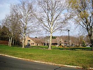
Crawford Corners or Crawfords Corner is an unincorporated community located within Holmdel Township in Monmouth County, New Jersey, United States. The settlement is located at the intersection of Holmdel Road and Crawfords Corners Road in the hilly northern portion of the township. The settlement is located about one-half mile (0.80 km) from Crawford Hill, the highest point in Monmouth County. The area also includes the township's town hall, police department, and high school in addition to a New Jersey State Police barracks and the PNC Bank Arts Center off the Garden State Parkway. These buildings and landmarks comprise the eastern section of the settlement, homes and heavily treed lands are located on the west side of Holmdel Road, and Holmdel Park makes up the southern portion of the area.

Fairfield is an unincorporated community located within Howell Township in Monmouth County, New Jersey, United States. The community is centered on the intersection of County Route 524 (CR 524) and Ketchum Road, where the Colonial Era Our House Tavern is located. The area includes several small businesses, township offices and schools. There are also small farms and residential developments in the area. Fairfield was a stop on the Freehold and Jamesburg Agricultural Railroad

Herberts Corner is an unincorporated community located within Marlboro Township in Monmouth County, New Jersey, United States. The center of the community is located at the intersection of Wyncrest Road and Newman Springs Road.
Hillsdale is an unincorporated community located within Colts Neck and Marlboro townships in Monmouth County, New Jersey, United States. The community is located at the intersection of County Route 520 which runs east and west, Conover Road which heads north, and Boundary Road which heads south. The southeastern quadrant of this intersection is a part of Colts Neck while the other three are in Marlboro. The community is located atop a small hill and is largely rural. The Colts Neck quadrant is made up of a housing development while the Marlboro side is mostly forests, parkland, and the remains of the Marlboro Psychiatric Hospital.

Kirbys Mills is an unincorporated community located within Upper Freehold Township in Monmouth County, New Jersey, United States. Centered near the intersection of Burlington Path Road and Holmes Mill Road, the area consists of housing developments and small farms.

Lower Squankum is an unincorporated community located within Howell Township in Monmouth County, New Jersey, United States. The settlement is located along Lakewood-Farmingdale Road at its intersection with Herbertsville Road and Old Tavern Road in the eastern side of the township. It is also located near the boundary of Allaire State Park and is south of Interstate 195's exit 31. Nearby the community are the remains of the Lower Squankum Mill and the Lower Squankum Friends Burial Site, located within the median of CR 547 at the aforementioned interchange.
Stone Church is an unincorporated community located in Middletown Township in Monmouth County, New Jersey, United States, within the census-designated place of Navesink. The settlement is located at the intersection of Valley Road and Locust Avenue, Navesink Avenue, and Monmouth Avenue. In the center of the community, the historic All Saint's Memorial Episcopal Church built in 1864 sits at the main intersection. The remainder of the area consists of single-family houses and forests on the slopes of nearby Mount Mitchill.


