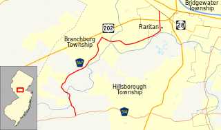
County Route 567, abbreviated CR 567, is a county highway in the U.S. state of New Jersey. The highway extends 10.02 miles (16.13 km) from Amwell Road in Hillsborough Township to Union Avenue in Raritan Borough.

Holmdel Dutch Reformed Church is a historic church at 41 Main Street in Holmdel Township, Monmouth County, New Jersey, United States.

Schneider Crossroads is an unincorporated community in Fairfax County, in the U.S. state of Virginia. State Route 620 and State Route 609 cross here and it is located 5.3 miles northwest by road from Centreville. It contains little more than a florists' and a site called Cox Farms. Pleasant Valley Golf Club lies to the northeast, with the two other quadrants also incorporated into yet undeveloped Fairfax County Park Authority parks. As the crossroads is a major traffic bottleneck, with traffic flow formally managed by 4-way stop signs, Loudoun County, just west of the crossroads, offered over a million of the county's funds in 2012 to pay for the intersection upgrade as their residents were inconvenienced the most by the traffic problem, although the intersection is completely in Fairfax County. The Virginia Department of Transportation determined that the optimal solution was a roundabout which was built from 2015 to 2016. Although traffic is much improved, the poor nature of the two-lane Braddock Road to the east of the traffic circle is now the main impediment of east-bound morning traffic.
Montrose is an unincorporated community located near the intersection of Dutch Lane Road and Boundary Road along the border of Colts Neck and Marlboro townships in Monmouth County, New Jersey, United States. The historic one-room Montrose Schoolhouse, built before 1820, is located in the Colts Neck portion of the community.

Spring Valley is an unincorporated community located within Marlboro Township in Monmouth County, New Jersey, United States. Located in the northern section of the township, the area is mainly forested with some businesses and cemeteries lining the main roads in the area, Spring Valley Road and Texas Road. U.S. Route 9, Route 18 and County Route 3 are major roads nearby Spring Valley.

Ackors Corner is an unincorporated community located within Hopewell Township in Mercer County, New Jersey, United States. The settlement is located at the intersection of Bear Tavern Road / Trenton-Harbourton Road, Pennington-Harbourton Road and Pleasant Valley Road. It is named for the Ackors family which owned land near the current intersection. Small residences and farmland make up the area surrounding Ackors Corner but the area rises in elevation from east to west as one approaches Baldpate Mountain, part of the Sourland Mountain range.

Union Valley is an unincorporated community located within Monroe Township in Middlesex County, New Jersey, United States. Two large age-restricted communities lie within the settlement today, Clearbrook Park and Concordia. Other than those two communities, the only other buildings in the area are medical offices and facilities and some single-family homes along Union Valley Road.

Centerville is an unincorporated community located along the border of Hazlet and Holmdel townships in Monmouth County, New Jersey, United States.

Everett is an unincorporated community located along the border of Holmdel and Middletown townships in Monmouth County, New Jersey, United States. The community is located on Everett Road, along which the township line runs, at its intersection with Stillwell Road and Sunnyside Road. Most of the area in Everett is composed of homes with some farmlands nearby. Holmdel's Bell Labs Complex is located to the west of Everett.
Crawford Corners or Crawfords Corner is an unincorporated community located within Holmdel Township in Monmouth County, New Jersey, United States. The settlement is located at the intersection of Holmdel Road and Crawfords Corners Road in the hilly northern portion of the township. The settlement is located about one-half mile (0.80 km) from Crawford Hill, the highest point in Monmouth County. The area also includes the township's town hall, police department, and high school in addition to a New Jersey State Police barracks and the PNC Bank Arts Center off the Garden State Parkway. These buildings and landmarks comprise the eastern section of the settlement, homes and heavily treed lands are located on the west side of Holmdel Road, and Holmdel Park makes up the southern portion of the area.

Hendrickson Corners is an unincorporated community located along the border of Holmdel and Middletown townships in Monmouth County, New Jersey, United States. The area primarily consists of commercial businesses along the Route 35 corridor; also nearby are an apartment complex and houses in developments throughout. County Route 516 has a brief concurrency with Route 35 in Hendricksons Corners; the easternmost intersection of the two roads is where the settlement is centered.
Holland is an unincorporated community located on the border of Holmdel and Middletown townships in Monmouth County, New Jersey, United States. The community is centered on the intersection of County Route 52 and Holland Road. The area making up Holland is hilly and consists of large single-family residences. An AT&T Labs campus is located off Laurel Avenue while Tatum County Park is also located in the area, both of which are on the Middletown side of the border.

Morrells Corner or Morrell Corners is an unincorporated community located within Holmdel and Hazlet townships in Monmouth County, New Jersey, United States. The main north-south road through here is Holmdel Road and the main east-west road is Bethany Road. Most of the area is suburban and consists of homes alongside roads with some businesses and the Hazlet NJ Transit station along the main roads.

Mount Pleasant is an unincorporated community located within Marlboro Township in Monmouth County, New Jersey, United States. It is named for a hill of the same name, one of the highest points in Marlboro Township. The settlement is located at the intersection of Reids Hill Road and Beacon Hill Road.

Philips Mills or Philip Mills is an unincorporated community located along the border of Holmdel and Middletown townships in Monmouth County, New Jersey, United States. It is located about the intersection of Palmer Avenue and Middle Road and Main Street. Around the area, some small businesses are located along the main arterial roads; single-family houses dot the area mostly towards the east side of the community. Throughout most of the west side, wooded areas lining the Waackaack Creek are found.

Pleasant Valley is an unincorporated community located within Marlboro Township in Monmouth County, New Jersey, United States. The area reportedly received its name from George Washington after he went through the area in 1777. The area is hilly and forested and is dotted by medium to large-sized residences. Pleasant Valley Road and Reids Hill Road are main roads that pass through the area connecting to Routes 34, 79, and 520. A large part of land which makes up Pleasant Valley was originally granted by the King of England in 1665 to the Rev. Obadiah Holmes. In 1690, the area was settled by people of Dutch heritage and the original dominant language in the area was Low Dutch.

Red Valley is an unincorporated community located within Upper Freehold Township in Monmouth County, New Jersey, United States. The settlement is located at the intersection of County Route 526 and Red Valley Road (south) and Yellow Meetinghouse Road (north) near the township's eastern border with Millstone Township. Except for some single-family houses located along the roads in the area, the area is primarily made up of farmland.

Smocks Corner or Smocks Corners is an unincorporated community located within Marlboro Township in Monmouth County, New Jersey, United States. Located at the intersection of Pleasant Valley Road and Conover Road, the area is mostly residences with some open space and farmland. It was called "Smocks Corner" because the Smock Family had houses in that area, both sides of the street back in the 1700s.

Crossroads is an unincorporated community located within Medford Township in Burlington County, New Jersey, United States. It is centered at the intersection of Medford-Mt. Holly Road and Church Road.


