
Englishtown is a borough in Monmouth County, New Jersey, United States. As of the 2010 United States Census, the borough's population was 1,847, reflecting an increase of 83 (+4.7%) from the 1,764 counted in the 2000 Census, which had in turn increased by 496 (+39.1%) from the 1,268 counted in the 1990 Census.

County Route 527, abbreviated CR 527, is a county highway in the U.S. state of New Jersey. The highway extends 84.86 mi (136.57 km) from Main Street in Toms River Township to Pompton Avenue in Cedar Grove. It passes through more counties (six) than any other county route in New Jersey. CR 527 is also the second longest 500-series county route in New Jersey after Route 519. It was first given the number 527 in 1954.

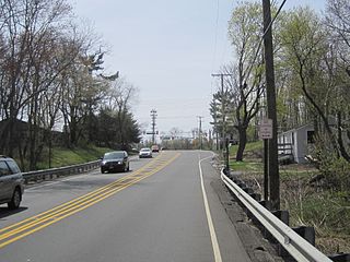
Millhurst is an unincorporated community located within Manalapan Township in Monmouth County, New Jersey, United States. Route 33 and County Route 527 pass through the center of Millhurst. Much of the area consists of businesses along the aforementioned arterial roads with the Millhurst Mill at the CR 527 crossing of Manalapan Brook. The mill is a former grist mill built in the 1700s, rebuilt in the 1800s as a more efficient mill, and turned into a family business by Bernard Hochberg in 1925.
Smithburg is an unincorporated community located where the municipal boundaries of Freehold, Manalapan and Millstone townships intersect in Monmouth County, New Jersey, United States. County Route 527 and Monmouth Road pass through the center of Smithburg.

Siloam is an unincorporated community located within Freehold Township in Monmouth County, New Jersey, United States. Siloam was once the site of a school serving a district in the township until 1936. County Route 527 passes through the center of Siloam. Exit 21 on Interstate 195 provides access to Siloam from the south. Except around the center of the settlement at the junction of CR 527 and Ely Harmony Road, the area consists of forests comprising the northernmost reaches of the Pine Barrens. The homes in the area are smaller in size and are found only along the aforementioned roads.

Whitesville is an unincorporated community located within Jackson Township in Ocean County, New Jersey, United States. County Route 527 and County Route 547 intersect the middle of Whitesville. The community is mostly a wooded area, with some commercial and residential development.

Texas is an unincorporated community located along the border of Monroe and Old Bridge townships in Middlesex County, New Jersey, United States. The two townships, split by the Matchaponix Brook, consist of similar land uses. Both have a mix of housing developments and forest land in the vicinity of the community. The main road that runs east and west through the community is Texas Road; it connects to County Route 520 towards the east and CR 612 on the west via Matchaponix Avenue. Other nearby roads in the vicinity include CR 527, CR 613, U.S. Route 9, and Route 18.

Carrs Tavern is an unincorporated community in Millstone Township in Monmouth County, New Jersey, United States. It is located at the intersection of County Route 526 and County Route 571.

Ackors Corner is an unincorporated community located within Hopewell Township in Mercer County, New Jersey, United States. The settlement is located at the intersection of Bear Tavern Road / Trenton-Harbourton Road, Pennington-Harbourton Road and Pleasant Valley Road. It is named for the Ackors family which owned land near the current intersection. Small residences and farmland make up the area surrounding Ackors Corner but the area rises in elevation from east to west as one approaches Baldpate Mountain, part of the Sourland Mountain range.

East Spotswood, also known as the settlement of Old Bridge, is an unincorporated community located within East Brunswick, New Jersey and Old Bridge townships in Middlesex County, New Jersey, United States. The area is made up of homes, businesses, and wetlands for the South River. The area is located at the junction of New Jersey Route 18, County Route 527, the western end of CR 516, and the Bordentown and South Amboy Turnpike. The still-active Jamesburg Branch of the former Camden & Amboy Railroad also runs through the community.

Bairdsville is an unincorporated community on the border of Manalapan and Millstone townships in Monmouth County, New Jersey, United States. The community is centered on the intersection of Woodville Road and Baird Road. Near the site of Bairdsville in Millstone is the Thomas Baird Homestead, a home owned by one of the first families to settle in Millstone.

Redshaw Corner is an unincorporated community located within Old Bridge Township in Middlesex County, New Jersey, United States. The settlement is located at the intersection of Old Bridge–Englishtown Road and Texas Road. A cluster of businesses are found around this intersection while some housing developments are located west of CR 527. New developments are in the process of being constructed in the sandy areas of land east of CR 527.

Charleston Springs is an unincorporated community located within Millstone Township in Monmouth County, New Jersey, United States. Stage Coach Road, also designated County Route 524, is the main road that runs through the settlement, with Ely Harmony Road as the intersecting road defining the locality. The Manalapan Brook runs to the west of the center of Charleston Springs and CR 537 runs to the south of the area. The Monmouth County-owned Charleston Springs Golf Course is located one mile (1.6 km) northeast of the center of Charleston Springs on CR 527.

Dogs Corners is an unincorporated community located within Ocean Township in Monmouth County, New Jersey, United States.

Hendrickson Corners is an unincorporated community located along the border of Holmdel and Middletown townships in Monmouth County, New Jersey, United States. The area primarily consists of commercial businesses along the Route 35 corridor; also nearby are an apartment complex and houses in developments throughout. County Route 516 has a brief concurrency with Route 35 in Hendricksons Corners; the easternmost intersection of the two roads is where the settlement is centered.

Herberts Corner is an unincorporated community located within Marlboro Township in Monmouth County, New Jersey, United States. The center of the community is located at the intersection of Wyncrest Road and Newman Springs Road.
Tiltons Corner or Tiltons Corners is an unincorporated community located where the municipal boundaries of Keansburg Borough, Hazlet Township and Middletown Township intersect in Monmouth County, New Jersey, United States.

Coxs Corner, also known as Cox's Corner or Wrightsville, is an unincorporated community located within Upper Freehold Township, in Monmouth County, New Jersey, United States. Named for congressman and brigadier general James Cox (1753–1810), who had lived here at the family home of "Box Grove", it is at the juncture of County Route 524 and County Route 43. The Upper Freehold Historic Farmland Byway passes through the area.
Van Marters Corner or Van Mariners Corners is an unincorporated community located along the border of Union Beach Borough and Hazlet Township in Monmouth County, New Jersey, United States.
Wileys Corner or Wileys Corners is an unincorporated community located within Tinton Falls in Monmouth County, New Jersey, United States.


