Rocky Brook is a tributary of the Millstone River in Monmouth and Mercer counties, New Jersey in the United States.

Windsor is a small historic unincorporated community located within Robbinsville Township in Mercer County, New Jersey, United States. The area is served as United States Postal Service ZIP Code 08561. There are approximately 50 homes in the area, and as of the 2010 United States Census, the population for ZIP Code Tabulation Area 08561 was 226. The community, covering 570 acres (230 ha), was added to the National Register of Historic Places in 1992.

Perrineville is an unincorporated community located within Millstone Township in Monmouth County, New Jersey, United States. The area is served as United States Postal Service ZIP code 08535.

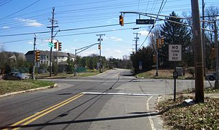
Gordons Corner is an unincorporated community located within Manalapan Township in Monmouth County, New Jersey, United States. The community is centered near the interchange with U.S. Route 9 (US 9), Tennent Road and Gordons Corner Road. Numerous strip malls and businesses line US 9 especially south of the interchange. The surrounding area is mostly made up of older housing developments though some farms are located on the north side of the community.

Coffins Corner is an unincorporated community located within Cherry Hill Township, in Camden County, New Jersey, United States. Located near the border of Voorhees, Coffins Corner is at the crossroads of County Route 561, County Route 544, and County Route 678.

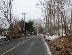
Fair Play is a rural unincorporated community located within Millstone Township, Monmouth County, New Jersey, United States. It is located just south of Disbrow Hill and north of Rocky Brook on County Route 1 at Fairplay Road, west of Perrineville and southeast of Hightstown.

Eilers Corner is an unincorporated community located within East Windsor Township in Mercer County, New Jersey, United States. It is located at the intersection of Old York Road and Windsor-Perrineville Road.

Baldwins Corner is an unincorporated community located within Hopewell Township in Mercer County, New Jersey, United States. The community is situated at the intersection of Pennington Road and Pennington-Lawrenceville Road.

Franklin Corner is an unincorporated community located within Lawrence Township in Mercer County, New Jersey, United States. The location of the community is centered on the intersection of Franklin Corner Road and Princeton Pike.

Ackors Corner is an unincorporated community located within Hopewell Township in Mercer County, New Jersey, United States. The settlement is located at the intersection of Bear Tavern Road / Trenton-Harbourton Road, Pennington-Harbourton Road and Pleasant Valley Road. It is named for the Ackors family which owned land near the current intersection. Small residences and farmland make up the area surrounding Ackors Corner but the area rises in elevation from east to west as one approaches Baldpate Mountain, part of the Sourland Mountain range.

Allens Corner is an unincorporated community located within Franklin Township in Hunterdon County, New Jersey, United States.

Furmans Corner is an unincorporated community located within East Amwell Township in Hunterdon County, New Jersey, United States. The area is very sparsely-populated with only a few homes located along the two roads in the area, Wertsville Road and North Hill Road. The remainder of the area consists of the Union Cemetery of Wertsville and farmland.
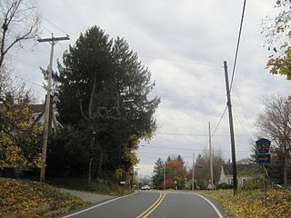
Voorhees Corner is an unincorporated community located within Raritan Township in Hunterdon County, New Jersey, United States. The settlement is located at the intersection of Old York Road and Voorhees Corner Road in the eastern extents of the township. Most of the area is suburban in nature consisting of single-family houses in developments with a recreational playing field park and some farmland nearby.
Moerls Corner or Moerle Corner is an unincorporated community located within Old Bridge Township in Middlesex County, New Jersey, United States. The intersection for which the corner is named is at Marlboro Road and Texas Road. The eastern quadrant of the intersection contains condominium units while the other three quadrants are sparsely-populated forest.

Claytons Corner is an unincorporated community located within Marlboro Township in Monmouth County, New Jersey, United States. The community is located along Gordons Corner Road near its intersections with Church Road and Robertsville Road and is completely suburban in nature as the area is part of houses in planned communities. The last remaining farm in Clayton's Corner belonged to the Yoncak family.
Crawford Corners or Crawfords Corner is an unincorporated community located within Holmdel Township in Monmouth County, New Jersey, United States. The settlement is located at the intersection of Holmdel Road and Crawfords Corners Road in the hilly northern portion of the township. The settlement is located about one-half mile (0.80 km) from Crawford Hill, the highest point in Monmouth County. The area also includes the township's town hall, police department, and high school in addition to a New Jersey State Police barracks and the PNC Bank Arts Center off the Garden State Parkway. These buildings and landmarks comprise the eastern section of the settlement, homes and heavily treed lands are located on the west side of Holmdel Road, and Holmdel Park makes up the southern portion of the area.

Herberts Corner is an unincorporated community located within Marlboro Township in Monmouth County, New Jersey, United States. The center of the community is located at the intersection of Wyncrest Road and Newman Springs Road.

Morrells Corner or Morrell Corners is an unincorporated community located within Holmdel and Hazlet townships in Monmouth County, New Jersey, United States. The main north-south road through here is Holmdel Road and the main east-west road is Bethany Road. Most of the area is suburban and consists of homes alongside roads with some businesses and the Hazlet NJ Transit station along the main roads.

Smocks Corner or Smocks Corners is an unincorporated community located within Marlboro Township in Monmouth County, New Jersey, United States. Located at the intersection of Pleasant Valley Road and Conover Road, the area is mostly residences with some open space and farmland. It was called "Smocks Corner" because the Smock Family had houses in that area, both sides of the street back in the 1700s.

Newbolds Corner is an unincorporated community located within Lumberton Township in Burlington County, New Jersey, United States. The site, located at the corner of Eayrestown Road and Newbolds Corner Road, was once home to a Nike missile silo which was fully demolished in late 2015. Today, the west side of Eayrestown Road consists of housing developments, Lumberton Township's town hall, and a school, while the east side of the road features farmland.