Ethnic groups in South Africa by municipality details the ethnic composition of South Africa by municipality, according to the 2011 census. [1]
Municipality | Province | African | Coloured | Indian or Asian | White | Other |
---|---|---|---|---|---|---|
Camdeboo Local Municipality | Eastern Cape | 24.8 | 64.8 | 0.4 | 9.6 | 0.4 |
Blue Crane Route Local Municipality | Eastern Cape | 59.0 | 33.0 | 0.3 | 6.8 | 0.8 |
Ikwezi Local Municipality | Eastern Cape | 37.2 | 54.6 | 0.2 | 7.6 | 0.5 |
Makana Local Municipality | Eastern Cape | 78.0 | 12.1 | 0.7 | 8.7 | 0.6 |
Ndlambe Local Municipality | Eastern Cape | 77.7 | 7.3 | 0.2 | 14.2 | 0.5 |
Sundays River Valley Local Municipality | Eastern Cape | 71.8 | 21.4 | 0.2 | 5.9 | 0.8 |
Baviaans Local Municipality | Eastern Cape | 12.0 | 80.3 | 0.2 | 7.0 | 0.6 |
Kouga Local Municipality | Eastern Cape | 38.8 | 42.6 | 0.2 | 17.6 | 0.7 |
Kou-Kamma Local Municipality | Eastern Cape | 30.6 | 59.8 | 0.3 | 8.2 | 1.1 |
Mbhashe Local Municipality | Eastern Cape | 99.4 | 0.1 | 0.1 | 0.2 | 0.1 |
Mnquma Local Municipality | Eastern Cape | 99.4 | 0.2 | 0.1 | 0.2 | 0.1 |
Great Kei Local Municipality | Eastern Cape | 91.3 | 1.3 | 0.1 | 7.1 | 0.2 |
Amahlathi Local Municipality | Eastern Cape | 96.5 | 1.2 | 0.1 | 2.0 | 0.2 |
Ngqushwa Local Municipality | Eastern Cape | 99.2 | 0.2 | 0.1 | 0.4 | 0.1 |
Nkonkobe Local Municipality | Eastern Cape | 94.5 | 4.0 | 0.2 | 1.0 | 0.3 |
Nxuba Local Municipality | Eastern Cape | 73.5 | 20.6 | 0.3 | 4.9 | 0.7 |
Inxuba Yethemba Local Municipality | Eastern Cape | 56.2 | 32.2 | 0.3 | 10.5 | 0.8 |
Tsolwana Local Municipality | Eastern Cape | 91.0 | 5.8 | 0.1 | 2.8 | 0.3 |
Inkwanca Local Municipality | Eastern Cape | 89.1 | 4.1 | 0.2 | 6.2 | 0.5 |
Lukanji Local Municipality | Eastern Cape | 92.6 | 3.8 | 0.5 | 2.7 | 0.4 |
Intsika Yethu Local Municipality | Eastern Cape | 99.4 | 0.2 | 0.1 | 0.1 | 0.1 |
Emalahleni Local Municipality | Eastern Cape | 98.5 | 0.6 | 0.1 | 0.6 | 0.2 |
Engcobo Local Municipality | Eastern Cape | 99.6 | 0.1 | 0.1 | 0.1 | 0.1 |
Sakhisizwe Local Municipality | Eastern Cape | 97.7 | 0.8 | 0.2 | 1.1 | 0.2 |
Elundini Local Municipality | Eastern Cape | 98.1 | 1.0 | 0.1 | 0.7 | 0.1 |
Senqu Local Municipality | Eastern Cape | 97.3 | 1.2 | 0.2 | 1.1 | 0.2 |
Maletswai Local Municipality | Eastern Cape | 85.3 | 7.4 | 0.2 | 6.7 | 0.4 |
Gariep Local Municipality | Eastern Cape | 72.9 | 17.8 | 0.3 | 8.7 | 0.4 |
Ngquza Hill Local Municipality | Eastern Cape | 99.2 | 0.4 | 0.1 | 0.1 | 0.1 |
Port St Johns Local Municipality | Eastern Cape | 99.3 | 0.4 | 0.1 | 0.2 | 0.0 |
Nyandeni Local Municipality | Eastern Cape | 99.4 | 0.3 | 0.1 | 0.1 | 0.1 |
Mhlontlo Local Municipality | Eastern Cape | 99.4 | 0.2 | 0.1 | 0.2 | 0.1 |
King Sabata Dalindyebo Local Municipality | Eastern Cape | 98.5 | 0.8 | 0.3 | 0.3 | 0.2 |
Matatiele Local Municipality | Eastern Cape | 98.1 | 0.9 | 0.3 | 0.7 | 0.1 |
Umzimvubu Local Municipality | Eastern Cape | 99.4 | 0.3 | 0.1 | 0.1 | 0.1 |
Mbizana Local Municipality | Eastern Cape | 99.6 | 0.2 | 0.1 | 0.1 | 0.0 |
Ntabankulu Local Municipality | Eastern Cape | 99.4 | 0.4 | 0.1 | 0.1 | 0.1 |
Buffalo City Metropolitan Municipality | Eastern Cape | 85.1 | 6.0 | 0.8 | 7.7 | 0.3 |
Nelson Mandela Bay Metropolitan Municipality | Eastern Cape | 60.1 | 23.6 | 1.1 | 14.4 | 0.8 |
Letsemeng Local Municipality | Free State | 67.8 | 23.4 | 0.3 | 8.1 | 0.4 |
Kopanong Local Municipality | Free State | 71.5 | 18.2 | 0.4 | 9.4 | 0.5 |
Mohokare Local Municipality | Free State | 90.8 | 2.3 | 0.3 | 6.5 | 0.2 |
Naledi Local Municipality | Free State | 92.4 | 1.9 | 0.5 | 4.9 | 0.3 |
Masilonyana Local Municipality | Free State | 91.6 | 1.1 | 0.3 | 6.7 | 0.3 |
Tokologo Local Municipality | Free State | 84.5 | 4.6 | 0.7 | 9.9 | 0.3 |
Tswelopele Local Municipality | Free State | 91.2 | 1.2 | 0.4 | 6.9 | 0.3 |
Matjhabeng Local Municipality | Free State | 87.7 | 2.1 | 0.4 | 9.6 | 0.2 |
Nala Local Municipality | Free State | 93.1 | 0.6 | 0.3 | 5.8 | 0.2 |
Setsoto Local Municipality | Free State | 92.3 | 1.0 | 0.8 | 5.7 | 0.2 |
Dihlabeng Local Municipality | Free State | 87.4 | 1.5 | 0.5 | 10.4 | 0.2 |
Nketoana Local Municipality | Free State | 91.4 | 0.3 | 0.2 | 7.8 | 0.2 |
Maluti a Phofung Local Municipality | Free State | 98.2 | 0.2 | 0.2 | 1.3 | 0.1 |
Phumelela Local Municipality | Free State | 91.6 | 0.4 | 0.3 | 7.3 | 0.3 |
Mantsopa Local Municipality | Free State | 88.4 | 3.9 | 0.6 | 6.6 | 0.5 |
Moqhaka Local Municipality | Free State | 87.2 | 2.9 | 0.3 | 9.3 | 0.3 |
Ngwathe Local Municipality | Free State | 86.5 | 2.6 | 0.3 | 10.3 | 0.3 |
Metsimaholo Local Municipality | Free State | 82.3 | 0.7 | 0.3 | 16.4 | 0.3 |
Mafube Local Municipality | Free State | 91.9 | 0.6 | 0.3 | 7.0 | 0.2 |
Mangaung Metropolitan Municipality | Free State | 83.3 | 5.0 | 0.4 | 11.0 | 0.3 |
Emfuleni Local Municipality | Gauteng | 85.4 | 1.2 | 1.0 | 12.0 | 0.4 |
Midvaal Local Municipality | Gauteng | 58.4 | 1.6 | 0.8 | 38.7 | 0.5 |
Lesedi Local Municipality | Gauteng | 77.3 | 1.2 | 1.3 | 19.7 | 0.6 |
Mogale City Local Municipality | Gauteng | 75.6 | 0.8 | 2.2 | 21.0 | 0.5 |
Randfontein Local Municipality | Gauteng | 69.2 | 9.8 | 0.4 | 20.1 | 0.5 |
Westonaria Local Municipality | Gauteng | 91.4 | 0.7 | 0.3 | 7.0 | 0.6 |
Merafong City Local Municipality | Gauteng | 86.5 | 1.1 | 0.3 | 11.8 | 0.3 |
Ekurhuleni Metropolitan Municipality | Gauteng | 78.7 | 2.7 | 2.1 | 15.8 | 0.6 |
City of Johannesburg Metropolitan Municipality | Gauteng | 76.4 | 5.6 | 4.9 | 12.3 | 0.8 |
City of Tshwane Metropolitan Municipality | Gauteng | 75.4 | 2.0 | 1.8 | 20.1 | 0.7 |
Umzumbe Local Municipality | KwaZulu-Natal | 99.6 | 0.1 | 0.1 | 0.1 | 0.1 |
UMuziwabantu Local Municipality | KwaZulu-Natal | 97.9 | 1.1 | 0.4 | 0.5 | 0.2 |
Ezingoleni Local Municipality | KwaZulu-Natal | 98.7 | 0.2 | 0.2 | 0.8 | 0.1 |
Hibiscus Coast Local Municipality | KwaZulu-Natal | 82.4 | 1.4 | 5.1 | 10.8 | 0.2 |
Vulamehlo Local Municipality | KwaZulu-Natal | 98.9 | 0.2 | 0.5 | 0.3 | 0.1 |
Umdoni Local Municipality | KwaZulu-Natal | 76.7 | 1.2 | 13.3 | 8.5 | 0.3 |
uMshwathi Local Municipality | KwaZulu-Natal | 95.1 | 0.2 | 1.7 | 2.7 | 0.2 |
uMngeni Local Municipality | KwaZulu-Natal | 75.0 | 1.5 | 3.8 | 19.4 | 0.3 |
Mpofana Local Municipality | KwaZulu-Natal | 92.1 | 0.6 | 1.8 | 5.2 | 0.3 |
Impendle Local Municipality | KwaZulu-Natal | 98.9 | 0.3 | 0.1 | 0.5 | 0.2 |
The Msunduzi Local Municipality | KwaZulu-Natal | 81.1 | 2.9 | 9.8 | 6.0 | 0.3 |
Mkhambathini Local Municipality | KwaZulu-Natal | 94.8 | 0.3 | 1.0 | 3.7 | 0.2 |
Richmond Local Municipality | KwaZulu-Natal | 95.2 | 0.9 | 1.1 | 2.6 | 0.2 |
Emnambithi/Ladysmith Local Municipality | KwaZulu-Natal | 91.8 | 1.0 | 4.4 | 2.7 | 0.2 |
Indaka Local Municipality | KwaZulu-Natal | 99.6 | 0.1 | 0.2 | 0.1 | 0.0 |
Umtshezi Local Municipality | KwaZulu-Natal | 90.2 | 1.4 | 5.8 | 2.3 | 0.3 |
Okhahlamba Local Municipality | KwaZulu-Natal | 97.1 | 0.2 | 0.4 | 2.1 | 0.2 |
Imbabazane Local Municipality | KwaZulu-Natal | 99.5 | 0.1 | 0.1 | 0.2 | 0.1 |
Umhlabuyalingana Local Municipality | KwaZulu-Natal | 99.3 | 0.1 | 0.1 | 0.3 | 0.1 |
Jozini Local Municipality | KwaZulu-Natal | 99.2 | 0.1 | 0.2 | 0.3 | 0.2 |
The Big 5 False Bay Local Municipality | KwaZulu-Natal | 95.8 | 0.3 | 0.2 | 3.2 | 0.4 |
Hlabisa Local Municipality | KwaZulu-Natal | 99.4 | 0.1 | 0.2 | 0.1 | 0.2 |
Mtubatuba Local Municipality | KwaZulu-Natal | 98.1 | 0.4 | 0.3 | 1.1 | 0.1 |
uMhlathuze Local Municipality | KwaZulu-Natal | 87.7 | 0.9 | 3.8 | 7.3 | 0.2 |
Nkandla Local Municipality | KwaZulu-Natal | 99.6 | 0.1 | 0.1 | 0.1 | 0.1 |
Mfolozi Local Municipality | KwaZulu-Natal | 98.8 | 0.2 | 0.2 | 0.8 | 0.1 |
Ntambanana Local Municipality | KwaZulu-Natal | 99.4 | 0.2 | 0.2 | 0.2 | 0.1 |
uMlalazi Local Municipality | KwaZulu-Natal | 97.1 | 0.6 | 0.7 | 1.5 | 0.2 |
Mthonjaneni Local Municipality | KwaZulu-Natal | 98.5 | 0.4 | 0.2 | 0.7 | 0.2 |
Ingwe Local Municipality | KwaZulu-Natal | 98.7 | 0.2 | 0.1 | 0.8 | 0.1 |
Kwa Sani Local Municipality | KwaZulu-Natal | 87.9 | 0.9 | 0.4 | 10.5 | 0.4 |
Greater Kokstad Local Municipality | KwaZulu-Natal | 87.1 | 8.2 | 1.1 | 3.3 | 0.2 |
Ubuhlebezwe Local Municipality | KwaZulu-Natal | 97.5 | 1.2 | 0.4 | 0.8 | 0.1 |
Umzimkhulu Local Municipality | KwaZulu-Natal | 99.3 | 0.3 | 0.1 | 0.1 | 0.1 |
Endumeni Local Municipality | KwaZulu-Natal | 83.9 | 2.6 | 5.9 | 7.2 | 0.4 |
Nqutu Local Municipality | KwaZulu-Natal | 99.7 | 0.1 | 0.1 | 0.1 | 0.1 |
Msinga Local Municipality | KwaZulu-Natal | 99.6 | 0.1 | 0.1 | 0.2 | 0.1 |
Umvoti Local Municipality | KwaZulu-Natal | 94.6 | 0.8 | 2.2 | 2.2 | 0.2 |
Newcastle Local Municipality | KwaZulu-Natal | 91.9 | 0.8 | 3.2 | 3.9 | 0.2 |
Emadlangeni Local Municipality | KwaZulu-Natal | 92.7 | 1.3 | 0.1 | 5.7 | 0.2 |
Dannhauser Local Municipality | KwaZulu-Natal | 97.5 | 0.3 | 1.4 | 0.8 | 0.1 |
Abaqulusi Local Municipality | KwaZulu-Natal | 95.4 | 0.5 | 0.4 | 3.5 | 0.1 |
eDumbe Local Municipality | KwaZulu-Natal | 97.8 | 0.1 | 0.2 | 1.8 | 0.2 |
UPhongolo Local Municipality | KwaZulu-Natal | 98.1 | 0.1 | 0.1 | 1.5 | 0.1 |
Nongoma Local Municipality | KwaZulu-Natal | 99.5 | 0.1 | 0.2 | 0.1 | 0.1 |
Ulundi Local Municipality | KwaZulu-Natal | 99.5 | 0.1 | 0.1 | 0.2 | 0.1 |
Maphumulo Local Municipality | KwaZulu-Natal | 99.7 | 0.1 | 0.1 | 0.1 | 0.1 |
Mandeni Local Municipality | KwaZulu-Natal | 96.7 | 0.5 | 1.7 | 1.0 | 0.1 |
KwaDukuza Local Municipality | KwaZulu-Natal | 78.8 | 1.0 | 14.1 | 5.6 | 0.6 |
Ndwedwe Local Municipality | KwaZulu-Natal | 98.4 | 0.2 | 0.7 | 0.3 | 0.5 |
eThekwini Metropolitan Municipality | KwaZulu-Natal | 73.8 | 2.5 | 16.7 | 6.6 | 0.4 |
Greater Giyani Local Municipality | Limpopo | 99.5 | 0.1 | 0.3 | 0.1 | 0.1 |
Greater Letaba Local Municipality | Limpopo | 98.8 | 0.1 | 0.1 | 0.8 | 0.2 |
Greater Tzaneen Local Municipality | Limpopo | 96.4 | 0.2 | 0.4 | 3.0 | 0.1 |
Ba-Phalaborwa Local Municipality | Limpopo | 93.0 | 0.3 | 0.2 | 6.4 | 0.1 |
Maruleng Local Municipality | Limpopo | 95.5 | 0.3 | 0.2 | 3.8 | 0.2 |
Mutale Local Municipality | Limpopo | 99.3 | 0.1 | 0.1 | 0.5 | 0.1 |
Thulamela Local Municipality | Limpopo | 99.3 | 0.1 | 0.5 | 0.1 | 0.1 |
Musina Local Municipality | Limpopo | 94.0 | 0.3 | 0.5 | 4.8 | 0.3 |
Makhado Local Municipality | Limpopo | 97.3 | 0.2 | 0.4 | 2.0 | 0.1 |
Blouberg Local Municipality | Limpopo | 99.0 | 0.0 | 0.1 | 0.6 | 0.2 |
Aganang Local Municipality | Limpopo | 99.6 | 0.1 | 0.1 | 0.1 | 0.2 |
Molemole Local Municipality | Limpopo | 98.4 | 0.1 | 0.1 | 1.1 | 0.3 |
Polokwane Local Municipality | Limpopo | 92.9 | 0.9 | 0.7 | 5.2 | 0.2 |
Lepele-Nkumpi Local Municipality | Limpopo | 99.6 | 0.1 | 0.1 | 0.1 | 0.1 |
Thabazimbi Local Municipality | Limpopo | 84.3 | 0.6 | 0.2 | 14.4 | 0.4 |
Lephalale Local Municipality | Limpopo | 90.7 | 0.9 | 0.3 | 7.9 | 0.3 |
Mookgopong Local Municipality | Limpopo | 85.6 | 0.4 | 0.2 | 13.2 | 0.6 |
Modimolle Local Municipality | Limpopo | 88.1 | 0.4 | 0.4 | 10.8 | 0.3 |
Bela-Bela Local Municipality | Limpopo | 84.8 | 1.5 | 0.6 | 12.9 | 0.3 |
Mogalakwena Local Municipality | Limpopo | 96.1 | 0.1 | 0.5 | 3.0 | 0.2 |
Ephraim Mogale Local Municipality | Limpopo | 97.8 | 0.1 | 0.2 | 1.6 | 0.3 |
Elias Motsoaledi Local Municipality | Limpopo | 97.9 | 0.1 | 0.2 | 1.6 | 0.2 |
Makhuduthamaga Local Municipality | Limpopo | 99.7 | 0.0 | 0.1 | 0.1 | 0.1 |
Fetakgomo Local Municipality | Limpopo | 99.4 | 0.0 | 0.1 | 0.4 | 0.1 |
Greater Tubatse Local Municipality | Limpopo | 98.3 | 0.2 | 0.2 | 1.3 | 0.1 |
Albert Luthuli Local Municipality | Mpumalanga | 97.6 | 0.2 | 0.4 | 1.6 | 0.2 |
Msukaligwa Local Municipality | Mpumalanga | 88.1 | 0.6 | 1.1 | 9.8 | 0.3 |
Mkhondo Local Municipality | Mpumalanga | 94.7 | 0.5 | 0.8 | 3.7 | 0.2 |
Pixley Ka Seme Local Municipality | Mpumalanga | 90.5 | 0.6 | 1.2 | 7.4 | 0.3 |
Lekwa Local Municipality | Mpumalanga | 84.2 | 2.9 | 1.2 | 11.4 | 0.3 |
Dipaleseng Local Municipality | Mpumalanga | 89.8 | 0.5 | 0.9 | 8.6 | 0.2 |
Govan Mbeki Local Municipality | Mpumalanga | 80.5 | 1.5 | 1.5 | 16.0 | 0.4 |
Victor Khanye Local Municipality | Mpumalanga | 82.3 | 1.1 | 0.3 | 16.0 | 0.3 |
Emalahleni Local Municipality | Mpumalanga | 81.3 | 1.7 | 0.9 | 15.7 | 0.4 |
Steve Tshwete Local Municipality | Mpumalanga | 73.6 | 2.6 | 1.6 | 21.8 | 0.4 |
Emakhazeni Local Municipality | Mpumalanga | 87.2 | 1.2 | 0.7 | 10.8 | 0.2 |
Thembisile Local Municipality | Mpumalanga | 99.2 | 0.2 | 0.3 | 0.1 | 0.2 |
Dr JS Moroka Local Municipality | Mpumalanga | 99.4 | 0.1 | 0.3 | 0.1 | 0.1 |
Thaba Chweu Local Municipality | Mpumalanga | 81.6 | 2.6 | 0.6 | 14.5 | 0.6 |
Mbombela Local Municipality | Mpumalanga | 89.4 | 0.9 | 0.7 | 8.7 | 0.2 |
Umjindi Local Municipality | Mpumalanga | 87.0 | 2.0 | 1.0 | 9.8 | 0.2 |
Nkomazi Local Municipality | Mpumalanga | 97.7 | 0.2 | 0.3 | 1.6 | 0.1 |
Bushbuckridge Local Municipality | Mpumalanga | 99.5 | 0.1 | 0.1 | 0.2 | 0.1 |
Moretele Local Municipality | North West | 99.4 | 0.2 | 0.1 | 0.2 | 0.1 |
Madibeng Local Municipality | North West | 89.3 | 0.9 | 0.5 | 8.9 | 0.4 |
Rustenburg Local Municipality | North West | 88.5 | 0.9 | 0.8 | 9.4 | 0.4 |
Kgetlengrivier Local Municipality | North West | 80.1 | 1.7 | 0.9 | 16.8 | 0.6 |
Moses Kotane Local Municipality | North West | 98.3 | 0.3 | 0.5 | 0.8 | 0.2 |
Ratlou Local Municipality | North West | 98.2 | 0.7 | 0.2 | 0.7 | 0.1 |
Tswaing Local Municipality | North West | 92.4 | 1.4 | 0.3 | 5.6 | 0.2 |
Mafikeng Local Municipality | North West | 95.5 | 2.3 | 0.8 | 1.3 | 0.2 |
Ditsobotla Local Municipality | North West | 89.1 | 1.9 | 0.6 | 8.2 | 0.3 |
Ramotshere Moiloa Local Municipality | North West | 94.4 | 0.9 | 0.7 | 3.8 | 0.3 |
Naledi Local Municipality | North West | 74.0 | 14.7 | 1.1 | 9.5 | 0.6 |
Mamusa Local Municipality | North West | 91.5 | 2.2 | 0.5 | 5.5 | 0.3 |
Greater Taung Local Municipality | North West | 98.2 | 1.0 | 0.2 | 0.4 | 0.1 |
Lekwa-Teemane Local Municipality | North West | 81.2 | 7.4 | 0.6 | 10.4 | 0.4 |
Kagisano/Molopo Local Municipality | North West | 96.0 | 1.4 | 0.2 | 2.1 | 0.3 |
Ventersdorp Local Municipality | North West | 90.1 | 2.7 | 0.3 | 5.9 | 1.0 |
Tlokwe Local Municipality | North West | 71.3 | 6.8 | 0.9 | 20.6 | 0.4 |
City of Matlosana Local Municipality | North West | 81.0 | 3.5 | 0.8 | 14.5 | 0.3 |
Maquassi Hills Local Municipality | North West | 88.7 | 2.3 | 0.4 | 8.2 | 0.3 |
Richtersveld Local Municipality | Northern Cape | 13.1 | 76.6 | 0.5 | 8.5 | 1.4 |
Nama Khoi Local Municipality | Northern Cape | 4.2 | 88.1 | 0.5 | 6.6 | 0.8 |
Kamiesberg Local Municipality | Northern Cape | 5.3 | 85.6 | 0.5 | 8.1 | 0.5 |
Hantam Local Municipality | Northern Cape | 4.4 | 82.2 | 0.7 | 12.1 | 0.6 |
Karoo Hoogland Local Municipality | Northern Cape | 5.5 | 78.9 | 0.7 | 14.6 | 0.4 |
Khâi-Ma Local Municipality | Northern Cape | 17.6 | 75.1 | 0.4 | 6.0 | 0.8 |
Ubuntu Local Municipality | Northern Cape | 21.3 | 69.8 | 0.5 | 7.6 | 0.8 |
Umsobomvu Local Municipality | Northern Cape | 62.6 | 30.6 | 0.5 | 5.7 | 0.7 |
Emthanjeni Local Municipality | Northern Cape | 33.2 | 57.7 | 0.6 | 8.0 | 0.6 |
Kareeberg Local Municipality | Northern Cape | 4.8 | 85.1 | 0.5 | 9.1 | 0.5 |
Renosterberg Local Municipality | Northern Cape | 32.9 | 57.4 | 0.5 | 8.6 | 0.6 |
Thembelihle Local Municipality | Northern Cape | 15.2 | 70.7 | 0.5 | 13.1 | 0.4 |
Siyathemba Local Municipality | Northern Cape | 18.8 | 71.9 | 0.5 | 8.5 | 0.4 |
Siyancuma Local Municipality | Northern Cape | 33.0 | 57.5 | 0.7 | 7.5 | 1.4 |
Mier Local Municipality | Northern Cape | 4.0 | 90.4 | 0.6 | 4.4 | 0.6 |
Kai ǃGarib Local Municipality | Northern Cape | 28.3 | 62.2 | 0.8 | 6.3 | 2.3 |
ǁKhara Hais Local Municipality | Northern Cape | 23.1 | 65.2 | 0.7 | 9.9 | 1.2 |
ǃKheis Local Municipality | Northern Cape | 6.9 | 85.4 | 1.0 | 5.4 | 1.4 |
Tsantsabane Local Municipality | Northern Cape | 52.8 | 37.6 | 0.6 | 8.4 | 0.6 |
Kgatelopele Local Municipality | Northern Cape | 49.9 | 38.9 | 0.7 | 9.8 | 0.8 |
Sol Plaatjie Local Municipality | Northern Cape | 61.2 | 27.4 | 1.2 | 7.5 | 2.7 |
Dikgatlong Local Municipality | Northern Cape | 58.5 | 28.5 | 0.6 | 3.6 | 8.9 |
Magareng Local Municipality | Northern Cape | 80.0 | 13.9 | 0.7 | 5.1 | 0.3 |
Phokwane Local Municipality | Northern Cape | 81.9 | 11.0 | 0.4 | 6.3 | 0.5 |
Joe Morolong Local Municipality | Northern Cape | 96.4 | 2.0 | 0.3 | 1.2 | 0.2 |
Ga-Segonyana Local Municipality | Northern Cape | 87.0 | 7.6 | 0.4 | 4.6 | 0.4 |
Gamagara Local Municipality | Northern Cape | 55.0 | 28.7 | 0.6 | 14.0 | 1.7 |
Matzikama Local Municipality | Western Cape | 8.5 | 74.7 | 0.6 | 14.8 | 1.3 |
Cederberg Local Municipality | Western Cape | 12.7 | 75.7 | 0.3 | 11.0 | 0.4 |
Bergrivier Local Municipality | Western Cape | 11.3 | 70.9 | 0.4 | 16.9 | 0.4 |
Saldanha Bay Local Municipality | Western Cape | 24.5 | 55.8 | 0.8 | 18.0 | 0.9 |
Swartland Local Municipality | Western Cape | 18.3 | 64.8 | 0.5 | 15.6 | 0.7 |
Witzenberg Local Municipality | Western Cape | 25.3 | 65.9 | 0.2 | 7.7 | 0.8 |
Drakenstein Local Municipality | Western Cape | 22.7 | 62.5 | 0.4 | 13.5 | 0.9 |
Stellenbosch Local Municipality | Western Cape | 28.1 | 52.2 | 0.4 | 18.5 | 0.8 |
Breede Valley Local Municipality | Western Cape | 24.3 | 63.3 | 0.6 | 10.7 | 1.1 |
Langeberg Local Municipality | Western Cape | 16.3 | 70.3 | 0.3 | 12.3 | 0.9 |
Swellendam Local Municipality | Western Cape | 12.4 | 68.8 | 0.3 | 17.4 | 1.1 |
Theewaterskloof Local Municipality | Western Cape | 26.4 | 62.9 | 0.4 | 9.4 | 0.9 |
Overstrand Local Municipality | Western Cape | 36.2 | 31.0 | 0.3 | 31.2 | 1.2 |
Cape Agulhas Local Municipality | Western Cape | 11.5 | 65.6 | 0.3 | 21.6 | 0.9 |
Kannaland Local Municipality | Western Cape | 4.7 | 84.6 | 0.3 | 9.9 | 0.5 |
Hessequa Local Municipality | Western Cape | 7.4 | 68.5 | 0.4 | 23.2 | 0.4 |
Mossel Bay Local Municipality | Western Cape | 29.5 | 43.5 | 0.5 | 25.5 | 1.1 |
George Local Municipality | Western Cape | 28.2 | 50.4 | 0.5 | 19.7 | 1.2 |
Oudtshoorn Local Municipality | Western Cape | 9.1 | 77.3 | 0.3 | 12.5 | 0.7 |
Bitou Local Municipality | Western Cape | 45.2 | 31.2 | 0.5 | 16.9 | 6.1 |
Knysna Local Municipality | Western Cape | 36.1 | 40.9 | 0.4 | 21.0 | 1.6 |
Laingsburg Local Municipality | Western Cape | 7.0 | 79.0 | 0.2 | 13.3 | 0.5 |
Prince Albert Local Municipality | Western Cape | 2.8 | 84.5 | 0.3 | 11.8 | 0.6 |
Beaufort West Local Municipality | Western Cape | 16.3 | 73.5 | 0.5 | 9.2 | 0.5 |
City of Cape Town Metropolitan Municipality | Western Cape | 38.6 | 42.4 | 1.4 | 15.7 | 1.9 |
The population of South Africa is about 60.1 million people of diverse origins, cultures, languages, and religions. The 2011 South African census was the most recent held; the next will be in 2022.
Priboj is a town and municipality located in the Zlatibor District of southwestern Serbia. The population of the town is 14,920, while the population of the municipality is 27,133.
The Dubrovnik-Neretva County is the southernmost county of Croatia, located in south Dalmatia. The county seat is Dubrovnik and other large towns are Korčula, Metković, Opuzen and Ploče. The Municipality of Neum, which belongs to neighbouring Bosnia and Herzegovina, divides the county in two parts which are connected only by the Pelješac Bridge. The southern part of the county consists of Dubrovnik and the surrounding area, including the Pelješac peninsula, and the islands of Korčula, Lastovo, Mljet, Šipan, Lopud and Koločep. The northern part of the county includes the Neretva Delta, the Baćina lakes north of Ploče, and a swath of hinterland near the southernmost slopes of Biokovo and around the hill of Rujnica. The northern part of the Mljet island is a national park. The Lastovo archipelago is a designated nature park. The southernmost tip of the county is the Prevlaka peninsula at the border with Montenegro. It is the only Croatian county that borders Montenegro.
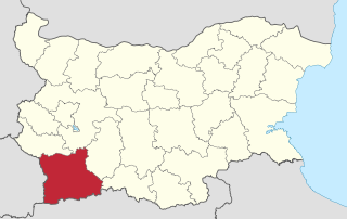
Blagoevgrad Province, also known as Pirin Macedonia or Bulgarian Macedonia, is a province (oblast) of southwestern Bulgaria. It borders four other Bulgarian provinces to the north and east, the Greek region of Macedonia to the south, and North Macedonia to the west. The province has 14 municipalities with 12 towns. Its principal city is Blagoevgrad, while other significant towns include Bansko, Gotse Delchev, Melnik, Petrich, Razlog, Sandanski, and Simitli.
Kardzhali Province is a province of southern Bulgaria, neighbouring Greece with the Greek regional units of Xanthi, Rhodope, and Evros to the south and east. It is 3209.1 km2 in area. Its main city is Kardzhali.
Kovačica is a town and municipality located in the South Banat District of the autonomous province of Vojvodina, Serbia. According to the 2011 census, the town has a population of 6,259, while Kovačica municipality has 25,274 inhabitants. It is widely known for its naïve art that the local residents make without any form of art school.
Roodepoort is a town in the Gauteng province of South Africa. Formerly an independent municipality, Roodepoort became part of the Johannesburg municipality in the late 1990s, along with Randburg and Sandton. Johannesburg's most famous botanical garden, Witwatersrand National Botanical Gardens, is located in Roodepoort.
Witbank, officially Emalahleni, is a city situated on the Highveld of Mpumalanga, South Africa, within the Emalahleni Local Municipality. The name Witbank is Afrikaans for "white ridge", and is named after a white sandstone outcrop where wagon transport drivers rested. The city is known for its coal-mining in the surrounding region.
Glenhazel is a suburb of the Municipality of Johannesburg, South Africa. It is located in Region E, bordering Fairmount, Sandringham, Lyndhurst and Percelia Estate. The area lies on a sloping hill with a park in the valley.
The demographics of Toronto, Ontario, Canada make Toronto one of the most multicultural and multiracial cities in the world. In 2016, 51.5 percent of the residents of the city proper belonged to a visible minority group, compared with 49.1% in 2011, and 13.6% in 1981. Toronto also has established ethnic neighbourhoods such as the multiple Chinatowns, Corso Italia, Little Italy, Little India, Greektown, Koreatown, Little Jamaica, Little Portugal and Roncesvalles, which celebrate the city's multiculturalism. Data from the suburban municipalities are also included for some metrics as most of these municipalities are part of the Toronto CMA.
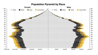
The United States of America has a racially and ethnically diverse population. At the federal level, race and ethnicity have been categorized separately. The most recent United States Census officially recognized five racial categories as well as people of two or more races. The Census Bureau also classified respondents as "Hispanic or Latino" or "Not Hispanic or Latino", identifying Hispanic and Latino as an ethnicity, which comprises the largest minority group in the nation. The Census also asked an "Ancestry Question," which covers the broader notion of ethnicity, in the 2000 Census long form and the 2010 American Community Survey; the question worded differently on “origins” will return in the 2020 Census.
Nova Varoš is a town and municipality located in the Zlatibor District of southwestern Serbia. The municipality of Nova Varoš has a population of 16,638, while the town of Nova Varoš itself has a population of 8,795 inhabitants.
Vhembe is one of the 5 districts of Limpopo province of South Africa. It is the northernmost district of the country and shares its northern border with Beitbridge district in Zimbabwe and on the east with Gaza Province in Mozambique. Vhembe consist of all territories that were part of the former Venda Bantustan, however, two large densely populated districts of the former Tsonga homeland of Gazankulu, in particular, Hlanganani and Malamulele were also incorporated into Vhembe, hence the ethnic diversity of the District. The seat of Vhembe is Thohoyandou, the capital of the former Venda Bantustan. According to 2011 census, the majority of Vhembe residents, about 800,000, speak TshiVenda as their mother language, while 400,000 speak Xitsonga as their home language. However, the Tsonga people are in majority south of Levubu River and they constitute more than 85% of the population in the south of the historic river Levubu, while the Venda are the minority south of Levubu, at 15%. The Northern Sotho speakers number 27,000. The district code is DC34.
Merošina is a village and municipality located in the Nišava District of the southern Serbia. According to 2011 census, the municipality has 13,968 inhabitants, from which 905 live in Merošina itself.
Doljevac is a small town and municipality located in the Nišava District of the southern Serbia. According to 2011 census, the municipality has 18,463 inhabitants, while the town has 1,657.
Gadžin Han is a village and municipality located in the Nišava District of the southern Serbia. According to 2011 census, the municipality has 8,389 inhabitants, from which 1,223 live in Gadžin Han itself.
Asian people are the people of Asia. The term may also refer to their descendants.
Racial groups in South Africa have a variety of origins. The racial categories introduced by Apartheid remain ingrained in South African society with South Africans continuing to classify themselves, and each other, as belonging to one of the four defined race groups. Statistics South Africa asks people to describe themselves in the census in terms of five racial population groups. The 2011 census figures for these categories were Black South African at 76.4%, White South African at 9.1%, Coloured South African at 8.9%, Indian South African at 2.5%, and Other/Unspecified at 0.5%.
Ga-Ramokadikadi is an affluent, large village in Ga-Matlala in the Polokwane Local Municipality of the Capricorn District Municipality of the Limpopo province of South Africa. It lies about 2 km south of Tibane and 54 km northwest of Polokwane on the Matlala Road.
Ga-Ngwetšana is a large village in Moletši in the Polokwane Local Municipality of the Capricorn District Municipality in the Limpopo province of the Republic of South Africa. It is located about 45 km northwest of the City of Polokwane on the R567 road.