
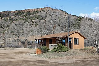
The Town of Hooper is a Statutory Town located in the San Luis Valley in Alamosa County, Colorado, United States. The population was 81 at the 2020 census.

The City of Sheridan is a home rule municipality located in Arapahoe County, Colorado, United States. Sheridan is a part of the Denver–Aurora–Lakewood, CO Metropolitan Statistical Area. The population was 6,105 at the 2020 census.

The Town of Raymer is a Statutory Town located in Weld County, Colorado, United States. The population was 110 at the U.S. Census 2020.
Burns is an unincorporated community in northern Eagle County, Colorado, United States.
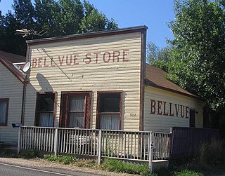
Bellvue is an unincorporated community and U.S. Post Office in Larimer County, Colorado. It is a small agricultural community located in Pleasant Valley, a narrow valley just northwest of Fort Collins near the mouth of the Poudre Canyon between the Dakota Hogback ridge and the foothills of the Rocky Mountains. The ZIP Code of the Bellvue Post Office is 80512.

Agate is an unincorporated community and U.S. Post Office in Elbert County, Colorado, United States. The ZIP Code of the Agate Post Office is 80101.
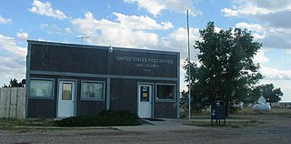
Carr is an unincorporated community that used to have a U.S. Post Office in Weld County, Colorado, United States. The ZIP Code of Carr is 80612. Some consider Carr a ghost town. Today, a few old houses remain plus a church and the schoolhouse, but the old store fronts are gone. There are some scattered old foundations throughout the town. There are a growing number of year-round residents, so the town no longer appears abandoned.

Altman is an extinct mining town located in Teller County, Colorado, United States. The Altman post office operated from January 18, 1894, until May 30, 1911. Much of the town was destroyed by fire on May 24, 1903.

Howardsville is an unincorporated community in San Juan County, Colorado, United States, along the Animas River at the mouth of Cunningham Creek. It is located about two miles from the town of Silverton and 8 miles from the famous ghost town of Animas Forks, and is on the same road as the ghost towns of Middleton and Eureka.
Adelaide is an extinct town located in Fremont County, Colorado, United States. The townsite is located at 38.5600°N 105.0908°W at an elevation of 6,949 feet (2,118 m). Previously known as Robinson, the former mining camp and railroad water is located along the Phantom Canyon Road. The Adelaide Bridge is located just north of the townsite.
Buckingham is an extinct town located in Weld County, Colorado, United States. The townsite is located at 40.6214°N 103.9777°W at an elevation of 4,944 feet (1,507 m).
Jimmy's Camp was a trading post established in 1833. The site is east of present-day Colorado Springs, Colorado on the southeast side of U.S. Route 24 and east of the junction with State Highway 94. Located along Trapper's Trail / Cherokee Trail, it was a rest stop for travelers and was known for its spring. Jimmy Camp was a ranch by 1870 and then a railway station on a spur of the Colorado and Southern Railway. After the ranch was owned by several individuals, it became part of the Banning Lewis Ranch. Now the land is an undeveloped park in Colorado Springs.

Franceville was a coal mining town and railroad post office in eastern El Paso County, Colorado, about five miles from the town of Falcon and twelve miles east of Colorado Springs. The Franceville post office operated from November 2, 1881, until May 14, 1894. The town was located on land owned by Matt France. There were 120 people in the town in 1885.
Bijou Basin is an extinct town located in El Paso County, Colorado, United States. The townsite is located at 39.1356°N 104.4569°W at an elevation of 6,398 feet (1,950 m). Travelers could take post road 49 to the settlement. It was located five miles southeast of another early settlement, Sidney.
Edgerton is an extinct town at the confluence of Monument Creek and West Monument Creek eight miles north of present-day Colorado Springs in El Paso County, Colorado, United States. It was across from Black Forest. The Edgerton post office operated from June 16, 1870, until August 28, 1902.
Gwillimsville was a settlement at the head of Cherry Creek and six miles east of Monument in northern El Paso County, Colorado. Its settlers were engaged in dairy, ranching, and timber businesses. The Gwillimsville post office operated from April 18, 1878, until September 25, 1890.
Baldwin is an extinct coal mining town located in Gunnison County, Colorado, United States. The townsite is located at 38.7639°N 107.0478°W at an elevation of 8,767 feet (2,672 m). The Baldwin post office operated from September 17, 1883, until September 30, 1948.
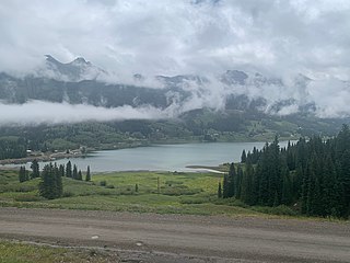
Trout Lake is a lake located in southeast San Miguel County, Colorado, in Uncompahgre National Forest. Trout Lake is a 15-minute drive from Ophir via Colorado State Highway 145 and a 20-minute drive from Telluride.
Sligo is a ghost town in Weld County, in the U.S. state of Colorado.

