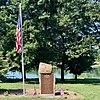
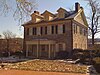
Marker title Image Date dedicated Location Marker type Topics Abraham Blumer - PLAQUE November 1, 1929 On grounds of Jordan United Church of Christ at Walbert, South Whitehall Twp. 40°36′49″N 75°34′01″W / 40.61352°N 75.567°W / 40.61352; -75.567 (Abraham Blumer - PLAQUE ) Plaque American Revolution, Ethnic & Immigration, Military, Religion Allentown September 3, 1947 S 4th St. (PA 145), just S of W Mountain Rd., Allentown Roadside Business & Industry, Cities & Towns, Government & Politics 18th Century Allentown September 3, 1947 MacArthur Rd. (PA 145) at N city line, just N of Sumner Ave. overpass, Allentown Roadside American Revolution, Business & Industry, Cities & Towns, Government & Politics Allentown September 3, 1947 Tilghman St. (old US 22) at 30th St., Allentown 40°36′59″N 75°30′24″W / 40.6164°N 75.50678°W / 40.6164; -75.50678 (Allentown ) Roadside American Revolution, Business & Industry, Cities & Towns, Government & Politics Allentown September 3, 1947 N 19th St. at Roth Ave., Allentown Roadside American Revolution, Business & Industry, Cities & Towns, Government & Politics Allentown September 3, 1947 U.S. 309 South at Allentown Roadside American Revolution, Business & Industry, Cities & Towns, Government & Politics Biery's Port April 24, 1988 Corner Race & Lehigh Sts., Catasauqua City Business & Industry, Cities & Towns, Coal, Iron, Mills Crane Iron Works May 4, 1997 Front St. between Church & Wood Sts., Catasauqua 40°39′07″N 75°28′22″W / 40.65208°N 75.47287°W / 40.65208; -75.47287 (Crane Iron Works ) City Business & Industry, Coal, Furnaces, Iron David Thomas May 20, 2001 Pine Street, Catasauqua 40°39′18″N 75°28′28″W / 40.6551°N 75.47443°W / 40.6551; -75.47443 (David Thomas ) City Business & Industry, Coal, Entrepreneurs, Ethnic & Immigration, Iron Dery Silk Mill October 18, 1998 101 Race Street, Catasauqua 40°38′57″N 75°28′04″W / 40.64917°N 75.4677°W / 40.64917; -75.4677 (Dery Silk Mill ) City Buildings, Business & Industry, Mills Emmaus July 26, 1966 Main St. at library, Emmaus 40°32′28″N 75°29′12″W / 40.54103°N 75.48653°W / 40.54103; -75.48653 (Emmaus ) Roadside Cities & Towns, Early Settlement, Native American, Religion First Cement September 2, 1947 Opposite Coplay Cement office bldg. at Coplay 40°40′34″N 75°29′53″W / 40.67617°N 75.498°W / 40.67617; -75.498 (First Cement ) Roadside Business & Industry First School Slate Factory October 23, 2003 Main and Factory Sts., Slatington 40°45′09″N 75°36′29″W / 40.75247°N 75.60805°W / 40.75247; -75.60805 (First School Slate Factory ) City Business & Industry, Education Fort Deshler October 7, 2001 Pa. 145 at Ironton Rail Trail 40°40′20″N 75°30′58″W / 40.67227°N 75.51608°W / 40.67227; -75.51608 (Fort Deshler ) Roadside Forts, French & Indian War, Military Fort Everett August 21, 1951 Pa. 143 E of Lynnport 40°40′38″N 75°48′03″W / 40.67713°N 75.80095°W / 40.67713; -75.80095 (Fort Everett ) Roadside Forts, French & Indian War, Military Frederick Leaser - PLAQUE November 1, 1928 Leaser Lake Park off PA 143 via Pleasure Ct. (at end of parking lot at flag pole), Jacksonville 40°40′15″N 75°50′00″W / 40.67078°N 75.83333°W / 40.67078; -75.83333 (Frederick Leaser - PLAQUE ) Plaque American Revolution George Taylor (1716-1781) n/a Lehigh St. just S of Race St., Catasaqua 40°38′49″N 75°28′01″W / 40.64708°N 75.46683°W / 40.64708; -75.46683 (George Taylor ) City Government & Politics, Government & Politics 18th Century, Iron Harriet A. Baker May 4, 1990 410 Union St., Allentown 40°36′03″N 75°27′51″W / 40.60095°N 75.4641°W / 40.60095; -75.4641 (Harriet A. Baker ) City African American, Religion, Women Indian Jasper Quarries October 23, 1952 SR 2027 near intersection SR 2023, Vera Cruz 40°30′26″N 75°29′48″W / 40.50732°N 75.49672°W / 40.50732; -75.49672 (Indian Jasper Quarries ) City Business & Industry, Native American Lehigh County October 30, 1982 Old Courthouse, 5th & Hamilton Sts., Allentown 40°36′12″N 75°28′05″W / 40.60333°N 75.46803°W / 40.60333; -75.46803 (Lehigh County ) City Government & Politics, Government & Politics 19th Century Lock Ridge Iron Furnace September 7, 2009 at Presbyterian church, 407 Franklin St. (at Church St.), Alburtis 40°30′33″N 75°35′54″W / 40.5093°N 75.5982°W / 40.5093; -75.5982 (Lock Ridge Iron Furnace ) Roadside Coal, Furnaces, Iron Portland Cement November 4, 1947 Iron Run Indus. Park., Tilghman St. (old U.S. 22), just W of Mill Rd. / Windsor Dr. intersection, W of Kuhnsville Roadside Business & Industry Samuel Wetherill (1821-1890) September 23, 2003 North side of Columbia between Webster and Adams Sts., Bethlehem 40°36′45″N 75°22′35″W / 40.61262°N 75.37651°W / 40.61262; -75.37651 (Samuel Wetherill ) City Business & Industry, Civil War, Invention, Medicine & Science, Military Slate Industry April 23, 2002 Intersection of Main and Railroad Streets, Slatington 40°45′11″N 75°36′16″W / 40.75298°N 75.60452°W / 40.75298; -75.60452 (Slate Industry ) Roadside Business & Industry, Entrepreneurs, Ethnic & Immigration Stephen Vincent Benet May 7, 1960 NE corner, Ostrum & Bishopthorpe Sts., Fountain Hill 40°36′26″N 75°23′38″W / 40.60715°N 75.39382°W / 40.60715; -75.39382 (Stephen Vincent Benet ) City Writers Trout Hall January 24, 1967 S. 4th St. near walnut St., Allentown 40°36′07″N 75°27′53″W / 40.60195°N 75.46467°W / 40.60195; -75.46467 (Trout Hall ) Roadside Education, Government & Politics, Government & Politics 18th Century, Mansions & Manors, Religion Troxell-Steckel House November 2, 1970 Main St. (PA 329) at Reliance St, beside church parking lot, Egypt 40°40′51″N 75°31′45″W / 40.68092°N 75.52908°W / 40.68092; -75.52908 (Troxell-Steckel House ) Roadside Buildings, Early Settlement, Houses & Homesteads Troxell-Steckel House November 2, 1970 S Church St. (Rt. 1023) near Bridge St., Egypt 40°40′45″N 75°31′45″W / 40.67923°N 75.52917°W / 40.67923; -75.52917 (Troxell-Steckel House ) Roadside Buildings, Early Settlement, Houses & Homesteads Trucker's Mill January 11, 1952 Main St. (Pa. 873) near Diamond St., Slatington 40°45′10″N 75°36′38″W / 40.75278°N 75.61043°W / 40.75278; -75.61043 (Trucker's Mill ) City Forts, French & Indian War, Military, Mills, Roads