List of census-designated places in Nebraska by population

Last updated

Map of the United States with Nebraska highlighted Nebraska in United States.svg
Map of the United States with Nebraska highlighted

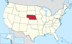
Nebraska is a state located in the Midwestern United States that is divided into 93 counties and contains 50 census-designated places (CDPs). [1] All population data is based on the 2010 census.

Contents

Census-Designated Places

Wehrspann Lake in Chalco Hills Recreation Area Chalco Lake and trail.jpg
Wehrspann Lake in Chalco Hills Recreation Area
Spruce Street in St. Libory St. Libory, Nebraska Spruce Street 3.JPG
Spruce Street in St. Libory
Champion Mill and dam in Champion Champion Mill dam from US 3.JPG
Champion Mill and dam in Champion
Archer Archer, NE.jpg
Archer
Inland Inland, NE.jpg
Inland
Berea Berea, Nebraska with train 1.JPG
Berea
Whiteclay Whiteclay, Nebraska from N 2.JPG
Whiteclay
NameCountyPopulation (2010) [1] Land area [1]
sq mikm2
Chalco Sarpy 10,9942.927.6
Offutt AFB Sarpy 4,6444.1610.8
Woodland Park Stanton 1,8661.534.0
Macy Thurston 1,0231.594.1
Glenwood Buffalo 4662.446.3
Lakeview Platte 3170.611.6
Walton Lancaster 3063.569.2
Yankee Hill Lancaster 2922.877.4
King Lake Douglas 2800.992.6
St. Libory Howard 2640.330.85
Belmar Keith 2164.5811.9
Woodland Hills Otoe 2150.360.93
Tryon McPherson 1571.193.1
Overland Hamilton 1531.193.1
Odessa Buffalo 1301.814.7
Inavale Webster 1170.330.85
Bow Valley Cedar 1160.140.36
La Platte Sarpy 1140.290.75
Aten Cedar 1121.704.4
Champion Chase 1030.240.62
Harrisburg Banner 1006.4716.8
Martin Keith 920.360.93
Wann Saunders 861.493.9
Lemoyne Keith 820.511.3
Archer Merrick 811.002.6
Venice Douglas 750.481.2
Sunol Cheyenne 732.195.7
Lisco Garden 640.601.6
Roscoe Keith 630.160.41
Inland Clay 620.170.44
Keystone Keith 590.200.52
Lorenzo Cheyenne 586.8417.7
Tamora Seward 580.992.6
Max Dundy 570.220.57
Fontanelle Dodge and Washington 540.250.65
Holmesville Gage 510.220.57
Richfield Sarpy 431.513.9
Enders Chase 420.130.34
Loretto Boone 420.280.73
Berea Box Butte 411.193.1
Westerville Custer 390.130.34
Sarben Keith 310.160.41
Willow Island Dawson 262.817.3
Ames Dodge 240.330.85
Parks Dundy 230.180.47
Raeville Boone 220.050.13
Poole Buffalo 192.707.0
Brownlee Cherry 150.110.28
Lindy Knox 131.002.6
Whiteclay Sheridan 100.070.18

See also

Related Research Articles

Washington County, Nebraska County in Nebraska, United States

Washington County is a county in the U.S. state of Nebraska. As of the 2010 United States Census, the population was 20,234. Its county seat is Blair.

Valley County, Nebraska County in Nebraska, United States

Valley County is a county in the U.S. state of Nebraska. As of the 2010 United States Census, the population was 4,260. Its county seat is Ord.

Sherman County, Nebraska County in Nebraska, United States

Sherman County is a county in the U.S. state of Nebraska. As of the 2010 United States Census, the population was 3,152. Its county seat is Loup City. The county was created in 1870, and was organized in 1872. It was named for American Civil War General William Tecumseh Sherman.

Polk County, Nebraska County in Nebraska, United States

Polk County is a county in the U.S. state of Nebraska. As of the 2010 United States Census, the population was 5,406. Its county seat is Osceola. The county was formed in 1856, and was organized in 1870. It was named for President James K. Polk.

Pawnee County, Nebraska County in Nebraska, United States

Pawnee County is a county in the U.S. state of Nebraska. As of the 2010 United States Census, the population was 2,773. Its county seat is Pawnee City.

Otoe County, Nebraska County in Nebraska, United States

Otoe County is a county in the U.S. state of Nebraska. As of the 2010 United States Census, the population was 15,740. Its county seat is Nebraska City. The county was formed in 1854, and was named tor the Otoe Indian tribe.

Nuckolls County, Nebraska County in Nebraska, United States

Nuckolls County is a county located in the U.S. state of Nebraska. As of the 2010 United States Census, the population was 4,500. Its county seat is Nelson.

Nance County, Nebraska County in Nebraska, United States

Nance County is a county in the U.S. state of Nebraska. As of the 2010 census, the population was 3,735. Its county seat is Fullerton.

Johnson County, Nebraska County in Nebraska, United States

Johnson County is a county in the U.S. state of Nebraska. As of the 2010 United States Census, the population was 5,217. Its county seat is Tecumseh. The county was formed in 1855, and was organized in 1857. It was named for Richard Mentor Johnson, who was Vice President of the United States from 1837 to 1841.

Harlan County, Nebraska County in Nebraska, United States

Harlan County is a county in the U.S. state of Nebraska. As of the 2010 United States Census, the population was 3,423. Its county seat is Alma. The county is home to the Harlan County Reservoir.

Greeley County, Nebraska County in Nebraska, United States

Greeley County is a county in the U.S. state of Nebraska. As of the 2010 census, the population was 2,538. Its county seat is Greeley.

Gage County, Nebraska County in Nebraska, United States

Gage County is a county in the U.S. state of Nebraska. As of the 2010 United States Census, the population was 22,311. Its county seat is Beatrice. The county was created in 1855 and organized in 1857. It was formed from land taken from the Otoe in an 1854 treaty. The county was named for W.D. Gage, a Methodist minister.

Franklin County, Nebraska County in Nebraska, United States

Franklin County is a county in the U.S. state of Nebraska. As of the 2010 census, the population was 3,225. Its county seat is Franklin. The county was formed in 1867 and organized in 1871. It was named for Benjamin Franklin.

Chase County, Nebraska County in Nebraska, United States

Chase County is a county in the U.S. state of Nebraska. As of the 2010 United States Census, the population was 3,966. Its county seat is Imperial.

Butler County, Nebraska County in Nebraska, United States

Butler County is a county in the U.S. state of Nebraska. As of the 2010 United States Census, the population was 8,395. Its county seat is David City. The county was created in 1856 and organized in 1868.

Boyd County, Nebraska County in Nebraska, United States

Boyd County is a county in the State of Nebraska. As of the 2010 United States Census, the population was 2,099. Its county seat is Butte. The county was formed in 1891 and named after James E. Boyd, the Nebraska Governor at the time.

Boone County, Nebraska County in Nebraska, United States

Boone County is a county in the U.S. state of Nebraska. As of the 2010 United States Census, the population was 5,505. Its county seat is Albion. The county was organized in 1871 and named after Daniel Boone.

Nebraska Panhandle Place

The Nebraska Panhandle is an area in the western part of the state of Nebraska and one of several U.S. state panhandles, or elongated geographical regions that extend from their main political entity.

References

  1. 1 2 3 "Nebraska: 2010 - Census Bureau" (PDF).