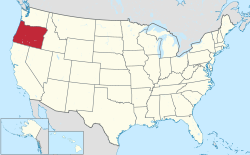
Oregon is a state located in the Western United States that is divided into 36 counties and contains 135 census designated-places (CDPs). [1] All population data is based on the 2020 census.
Oregon is a state located in the Western United States that is divided into 36 counties and contains 135 census designated-places (CDPs). [1] All population data is based on the 2020 census.


| Name | County | Population | Land area [1] | ||
|---|---|---|---|---|---|
| 2020 Census | 2010 Census [1] | sq mi | km2 | ||
| Aloha | Washington | 53,828 | 49,425 | 7.37 | 19.1 |
| Bethany | Washington | 20,646 | 20,646 | 5.14 | 13.3 |
| Altamont | Klamath | 20,223 | 19,257 | 8.10 | 21.0 |
| Hayesville | Marion | 19,936 | 19,936 | 3.07 | 8.0 |
| Oak Grove | Clackamas | 16,629 | 16,629 | 3.89 | 10.1 |
| Four Corners | Marion | 15,947 | 15,947 | 2.70 | 7.0 |
| Cedar Mill | Multnomah and Washington | 14,546 | 14,546 | 3.32 | 8.6 |
| Oatfield | Clackamas | 13,415 | 13,415 | 3.40 | 8.8 |
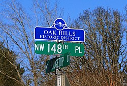
| Oak Hills | Washington | 11,333 | 11,333 | 1.56 | 4.0 |
| Santa Clara | Lane | 11,239 | |||
| Damascus | Clackamas | 11,050 | 657 | 1,700 | |
| Rockcreek | Washington | 9,316 | 9,316 | 1.96 | 5.1 |
| Bull Mountain | Washington | 9,133 | 9,133 | 2.91 | 7.5 |
| River Road | Lane | 8,732 | 8,732 | 1.82 | 4.7 |
| Cedar Hills | Washington | 8,300 | 8,300 | 1.91 | 4.9 |
| West Haven-Sylvan | Multnomah and Washington | 8,001 | 8,001 | 2.33 | 6.0 |
| White City | Jackson | 7,975 | 7,975 | 1.87 | 4.8 |
| Green | Douglas | 7,515 | 7,515 | 4.53 | 11.7 |
| Jennings Lodge | Clackamas | 7,315 | 7,315 | 1.60 | 4.1 |
| Garden Home–Whitford | Washington | 6,674 | 6,674 | 1.52 | 3.9 |
| West Slope | Washington | 6,554 | 6,554 | 1.62 | 4.2 |
| Roseburg North | Douglas | 5,912 | 5,912 | 22.33 | 57.8 |
| Raleigh Hills | Washington | 5,896 | 5,896 | 1.53 | 4.0 |
| Marlene Village | Washington | 5,485 | |||
| Deschutes River Woods | Deschutes | 5,077 | 5,077 | 5.96 | 15.4 |
| Crooked River Ranch | Deschutes and Jefferson | 4,912 | 12,000 | 49 | |
| Mount Hood Village | Clackamas | 4,864 | 4,864 | 26.14 | 67.7 |
| Beavercreek | Clackamas | 4,727 | 4,485 | 20.12 | 52.1 |
| Tri-City | Douglas | 3,931 | 3,931 | 7.22 | 18.7 |
| Metzger | Washington | 3,765 | 3,765 | 0.74 | 1.9 |
| Three Rivers | Deschutes | 3,014 | 3,014 | 7.53 | 19.5 |
| Warm Springs | Jefferson | 2,945 | 2,945 | 42.52 | 110.1 |
| Redwood | Josephine | 2,627 | 2,627 | 3.47 | 9.0 |
| Juniper Canyon | Crook | 2,564 | 96.33 | 249.5 | |
| Harbor | Curry | 2,391 | 2,391 | 1.92 | 5.0 |
| Odell | Hood River | 2,255 | 2,255 | 2.02 | 5.2 |
| Mulino | Clackamas | 2,103 | 2,103 | 13.78 | 35.7 |
| Lincoln Beach | Lincoln | 2,045 | 2,045 | 3.23 | 8.4 |
| Keno | Klamath | 1,980 | 9.57 | 24.8 | |
| Boring | Clackamas | 1,931 | 30.0 | 78 | |
| Heceta | Lane | 1,912 | 2.83 | 7.3 | |
| Rose Lodge | Lincoln | 1,894 | 1,894 | 9.54 | 24.7 |
| Chenoweth | Wasco | 1,855 | 1,855 | 5.61 | 14.5 |
| Barview | Coos | 1,890 | 1,844 | 1.38 | 3.6 |
| Glide | Douglas | 1,795 | 1,795 | 10.08 | 26.1 |
| Warren | Columbia | 1,787 | 1,787 | 6.30 | 16.3 |
| Dunthorpe | Multnomah | 1,704 | 1,704 | 1,619.77 | 4,195.2 |
| Eagle Crest | Deschutes | 1,696 | 1,696 | 15.19 | 39.3 |
| Grand Ronde | Polk and Yamhill | 1,661 | 1,661 | 0.70 | 1.8 |
| Merlin | Josephine | 1,615 | 1,615 | 19.20 | 49.7 |
| Stafford | Clackamas | 1,577 | 1,577 | 6.02 | 15.6 |
| Prineville Lake Acres | Crook | 1,556 | 6.59 | 17.1 | |
| New Hope | Josephine | 1,515 | 1,515 | 3.83 | 9.9 |
| Bunker Hill | Coos | 1,444 | 1,444 | 1.46 | 3.8 |
| Sunriver | Deschutes | 1,393 | 1,393 | 8.83 | 22.9 |
| Terrebonne | Deschutes | 1,257 | 1,257 | 1.01 | 2.6 |
| Williams | Josephine | 1,072 | 1,072 | 11.32 | 29.3 |
| Saunders Lake | Coos | 1,055 | 2.95 | 7.6 | |
| Mission | Umatilla | 1,037 | 1,037 | 7.61 | 19.7 |
| Pacific City | Tillamook | 1,035 | 1,035 | 3.72 | 9.6 |
| Knappa | Clatsop | 1,007 | 2.11 | 5.5 | |
| South Lebanon | Linn | 1,005 | 1,005 | 1.04 | 2.7 |
| Bayside Gardens | Tillamook | 1,214 | 880 | 0.99 | 2.6 |
| Bayshore | Lincoln | 952 | - | 2.47 | 6.4 |
| Dexter | Lane | 893 | 485.33 | 1,257.0 | |
| Running Y Ranch | Klamath | 858 | 5.36 | 13.9 | |
| Lookingglass | Douglas | 855 | 855 | 11.58 | 30.0 |
| Svensen | Clatsop | 853 | 2.26 | 5.9 | |
| Ruch | Jackson | 840 | 840 | 6.73 | 17.4 |
| Foots Creek | Jackson | 799 | 799 | 6.07 | 15.7 |
| Jasper | Lane | 793 | 793 | 2.72 | 7.0 |
| Glasgow | Coos | 763 | 763 | 3.22 | 8.3 |
| Netarts | Tillamook | 748 | 748 | 2.60 | 6.7 |
| Melrose | Douglas | 735 | 735 | 4.35 | 11.3 |
| Trail | Jackson | 702 | 702 | 6.80 | 17.6 |
| Selma | Josephine | 695 | 695 | 6.46 | 16.7 |
| Falcon Heights | Klamath | 680 | 680 | 1,626.79 | 4,213.4 |
| Wimer | Jackson | 678 | 678 | 4.96 | 12.8 |
| Green Meadows | Umatilla | 675 | 675 | 1.23 | 3.2 |
| Pleasant Valley | Tillamook | 620 | |||
| Neotsu | Lincoln | 608 | 608 | 1.41 | 3.7 |
| Kerby | Josephine | 595 | 595 | 2.58 | 6.7 |
| Marcola | Lane | 580 | 1.22 | 3.2 | |
| San Marine | Lincoln | 553 | 1.99 | 5.2 | |
| Elmira | Lane | 546 | 1.35 | 3.5 | |
| Lacomb | Linn | 546 | 546 | 3.98 | 10.3 |
| O'Brien | Josephine | 504 | 504 | 5.21 | 13.5 |
| Cherry Grove | Washington | 503 | 503 | 464.88 | 1,204.0 |
| Fairview | Tillamook | 498 | |||
| Pine Hollow | Wasco | 494 | 494 | 2.22 | 5.7 |
| Mapleton | Lane | 493 | 0.96 | 2.5 | |
| Tumalo | Deschutes | 488 | 488 | 1.71 | 4.4 |
| Tutuilla | Umatilla | 487 | 487 | 20.05 | 51.9 |
| Dillard | Douglas | 478 | 478 | 1.18 | 3.1 |
| Nesika Beach | Curry | 463 | 463 | 2.28 | 5.9 |
| Orient | Multnomah | 462 | 0.95 | 2.5 | |
| Prospect | Jackson | 455 | 455 | 3.50 | 9.1 |
| Ochoco West | Crook | 432 | 0.44 | 1.1 | |
| Wedderburn | Curry | 426 | 1.26 | 3.3 | |
| Crescent | Klamath | 412 | 1.17 | 3.0 | |
| Labish Village | Marion | 412 | 412 | 0.05 | 0.13 |
| Brooks | Marion | 398 | 398 | 0.52 | 1.3 |
| River Point | Clatsop | 397 | 0.60 | 1.6 | |
| Crabtree | Linn | 391 | 391 | 1.81 | 4.7 |
| Winchester Bay | Douglas | 382 | 382 | 2.31 | 6.0 |
| Gopher Flats | Umatilla | 379 | 379 | 2.11 | 5.5 |
| Holley | Linn | 378 | 378 | 2.82 | 7.3 |
| Takilma | Josephine | 378 | 378 | 5.94 | 15.4 |
| Jeffers Gardens | Clatsop | 368 | 368 | 0.57 | 1.5 |
| Black Butte Ranch | Deschutes | 366 | 366 | 8.20 | 21.2 |
| Oceanside | Tillamook | 361 | 361 | 1.04 | 2.7 |
| Trent | Lane | 339 | 1.61 | 4.2 | |
| Idaville | Tillamook | 337 | 337 | 0.49 | 1.3 |
| Crawfordsville | Linn | 332 | 332 | 1.92 | 5.0 |
| Oregon Shores | Klamath | 330 | 1.31 | 3.4 | |
| Cheshire | Lane | 329 | 0.47 | 1.2 | |
| Westport | Clatsop | 321 | 321 | 0.66 | 1.7 |
| Umapine | Umatilla | 315 | 315 | 3.32 | 8.6 |
| Marion | Marion | 313 | 313 | 1.15 | 3.0 |
| Parkdale | Hood River | 311 | 311 | 0.63 | 1.6 |
| Rocky Point | Klamath | 310 | |||
| Dilley | Washington | 301 | 0.75 | 1.9 | |
| Deer Island | Columbia | 294 | 294 | 0.49 | 1.3 |
| Mehama | Marion | 292 | 292 | 0.46 | 1.2 |
| Mount Hood | Hood River | 286 | 286 | 1.92 | 5.0 |
| Fair Oaks | Douglas | 278 | 278 | 1.84 | 4.8 |
| Days Creek | Douglas | 272 | 272 | 2.36 | 6.1 |
| Butteville | Marion | 265 | 265 | 1.05 | 2.7 |
| Rhododendron | Clackamas | 262 | 262 | ||
| Cloverdale | Tillamook | 250 | 250 | 0.80 | 2.1 |
| Gardiner | Douglas | 248 | 248 | 0.58 | 1.5 |
| Annex | Malheur | 225 | 235 | 2.46 | 6.4 |
| Camp Sherman | Jefferson | 233 | 233 | 3.15 | 8.2 |
| Hebo | Tillamook | 232 | 232 | 1.63 | 4.2 |
| Gilchrist | Klamath | 216 | 0.42 | 1.1 | |
| Bly | Klamath | 207 | 0.84 | 2.2 | |
| Tygh Valley | Wasco | 206 | 206 | 3.73 | 9.7 |
| Shedd | Linn | 204 | 204 | 1.51 | 3.9 |
| Riverside | Umatilla | 199 | 199 | 0.60 | 1.6 |
| Barnesdale | Tillamook | 193 | 0.74 | 1.9 | |
| Government Camp | Clackamas | 193 | 193 | 0.75 | 1.9 |
| Neahkahnie | Tillamook | 192 | 192 | 0.65 | 1.7 |
| Rowena | Wasco | 187 | 187 | 1.81 | 4.7 |
| Seventh Mountain | Deschutes | 187 | 187 | 1.95 | 5.1 |
| Kirkpatrick | Umatilla | 179 | 179 | 3.57 | 9.2 |
| Langlois | Curry | 177 | 177 | 1.43 | 3.7 |
| Alsea | Benton | 165 | 164 | 0.15 | 0.39 |
| Alpine | Benton | 164 | 171 | 0.81 | 2.1 |
| Silver Lake | Lake | 149 | 149 | 1.48 | 3.8 |
| Pine Grove | Wasco | 148 | 148 | 6.03 | 15.6 |
| Cascadia | Linn | 147 | 147 | 5.02 | 13.0 |
| Neskowin | Tillamook | 134 | 134 | 1.39 | 3.6 |
| Crane | Harney | 129 | 129 | 10.42 | 27.0 |
| Fort Hill | Polk and Yamhill | 129 | 129 | 1.45 | 3.8 |
| Beaver | Tillamook | 163 | 122 | 0.39 | 1.0 |
| New Pine Creek | Lake | 120 | 120 | 2.47 | 6.4 |
| West Scio | Linn | 120 | 120 | 0.34 | 0.88 |
| Crescent Lake | Klamath | 119 | 0.34 | 0.88 | |
| Harper | Malheur | 109 | 109 | 7.00 | 18.1 |
| Cape Meares | Tillamook | 99 | 99 | 2.51 | 6.5 |
| McKay | Umatilla | 95 | |||
| Peoria | Linn | 94 | 94 | 0.47 | 1.2 |
| Brogan | Malheur | 90 | 90 | 2.86 | 7.4 |
| Meacham | Umatilla | 85 | 85 | 1.21 | 3.1 |
| Wamic | Wasco | 85 | 85 | 1.21 | 3.1 |
| Pistol River | Curry | 84 | 84 | 0.59 | 1.5 |
| Summit | Benton | 82 | 82 | 0.31 | 0.80 |
| Sprague River | Klamath | 80 | 0.47 | 1.2 | |
| Chemult | Klamath | 79 | 0.26 | 0.67 | |
| Rickreall | Polk | 77 | 77 | 0.17 | 0.44 |
| Sportsmans Park | Wasco | 76 | 76 | 0.16 | 0.41 |
| Bellfountain | Benton | 75 | 75 | 1.30 | 3.4 |
| Cayuse | Umatilla | 68 | 68 | 2.88 | 7.5 |
| Kings Valley | Benton | 65 | 65 | 0.69 | 1.8 |
| Wallowa Lake | Wallowa | 62 | 62 | 1.83 | 4.7 |
| Blodgett | Benton | 58 | 58 | 0.56 | 1.5 |
| Beatty | Klamath | 60 | - | 0.97 | 2.5 |
| Juntura | Malheur | 57 | 57 | 2.29 | 5.9 |
| Plush | Lake | 57 | 57 | 1.62 | 4.2 |
| Beaver Marsh | Klamath | 52 | - | 0.33 | 0.85 |
| Eola | Polk | 45 | 45 | 0.05 | 0.13 |
| Tetherow | Deschutes | 45 | 45 | 2.11 | 5.5 |
| Fort Klamath | Klamath | 43 | 43 | ||
| Pronghorn | Deschutes | 34 | 34 | 6.60 | 17.1 |
| Biggs Junction | Sherman | 22 | 22 | 0.85 | 2.2 |