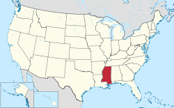
Mississippi is a state located in the Southern United States that is divided into 82 counties and contains 63 census-designated places (CDPs) [1] in 2018. All population data is based on the 2010 census.
Adams County is a county located in the U.S. state of Mississippi. As of the 2020 census, the population was 29,538. The county seat is Natchez.
Tallahatchie County is a county in the U.S. state of Mississippi. At the 2020 census, the population was 12,715. Its county seats are Charleston and Sumner.
Oktibbeha County is a county in the east central portion of the U.S. state of Mississippi. As of the 2020 census the population was 51,788. The county seat is Starkville. The county's name is derived from a local Native American word meaning either "bloody water" or "icy creek". The Choctaw had long occupied much of this territory prior to European exploration and United States acquisition.
Jasper County is located in the U.S. state of Mississippi. At the 2020 census, the population was 16,367. In 1906, the state legislature established two county courts, one at the first county seat of Paulding in the eastern part of the county and also one at Bay Springs in the west, where the railroad had been constructed. Jasper County is part of the Laurel, MS Micropolitan Statistical Area.
Jackson County is a county located in the U.S. state of Mississippi. As of the 2020 census, the population was 143,252, making it the fifth-most populous county in Mississippi. Its county seat is Pascagoula. The county was named for Andrew Jackson, general in the United States Army and afterward President of the United States.
Mississippi County is the easternmost county in the U.S. state of Arkansas. As of the 2020 census, the population was 40,685. There are two county seats, Blytheville and Osceola. The county is named for the Mississippi River which borders the county to the east. Mississippi County is part of the First Congressional District in Arkansas.
The following is a set–index article, providing a list of lists, for the cities, towns and villages within the jurisdictional United States. It is divided, alphabetically, according to the state, territory, or district name in which they are located.
Nottoway, or Nottoway Court House, is a census-designated place (CDP) in and the county seat of Nottoway County, Virginia, United States. The population at the time of the 2010 Census was 84. This had decreased to 63 by the 2020 Census.
The Hattiesburg Metropolitan Statistical Area is a metropolitan statistical area (MSA) in southeastern Mississippi that covers four counties - Covington, Forrest, Lamar, and Perry. The MSA's principal city is Hattiesburg. The 2010 census placed the Hattiesburg MSA's population at 162,410, though estimates as of 2019 indicate the population has increased to 168,849. The area is part of the geographical region known as the Pine Belt, famous for its abundance of longleaf pine trees. The Hattiesburg MSA is part of the larger Hattiesburg-Laurel Combined Statistical Area.
The Gulfport-Biloxi Metropolitan Statistical Area is a metropolitan statistical area (MSA) in the Mississippi Gulf Coast region that includes four counties – Hancock, Harrison, Jackson and Stone. The principal cities are Gulfport and Biloxi. The 2010 census placed the Gulfport-Biloxi MSA population at 388,488, though as of 2019, it was estimated to have increased to 417,665. The area was significantly impacted by Hurricane Katrina on August 29, 2005, and prior to the hurricane, had experienced steady to moderate population growth. However, growth has since rebounded, with the population steadily increasing every year throughout the 2010s.
The Pascagoula Metropolitan Statistical Area is a metropolitan area in the southeastern corner of Mississippi that covers two counties - Jackson and George. As of the 2000 census, the MSA had a population of 150,564. The area was significantly impacted by Hurricane Katrina in 2005. A July 1, 2009 estimate placed the population at 155,603. Prior to the hurricane, the area had experienced steady population growth. It is also part of the larger Gulfport-Biloxi-Pascagoula Combined Statistical Area.
The Jackson–Vicksburg–Brookhaven, MS Combined Statistical Area is made up of eight counties in central Mississippi and consists of the Jackson Metropolitan Statistical Area, the Brookhaven, MS Micropolitan Statistical Area, the Vicksburg micropolitan area, and the Yazoo City Micropolitan Statistical Area. The 2010 census placed the Jackson–Vicksburg–Brookhaven CSA population at 650,764, although as of 2019, it's estimated to have increased to 666,318.
The Greenwood Micropolitan Statistical Area is a micropolitan area in the northwestern Delta region of Mississippi that covers two counties - Leflore and Carroll. As of the 2000 census, the USA had a population of 48,716.
The Laurel Micropolitan Statistical Area is a micropolitan statistical area (μSA) in southeastern Mississippi that covers two counties - Jasper and Jones. The 2010 census placed the Laurel micropolitan area population at 84,823, though as of 2019, estimates indicate the population has slightly decreased to 84,481.
The Natchez Micropolitan Statistical Area is a micropolitan area that consists of Adams County, Mississippi and Concordia Parish, Louisiana. As of the 2000 census, it had a population of 54,587.
University is a census-designated place (CDP) and the official name for an area covering a portion of the University of Mississippi campus, in Lafayette County, Mississippi, United States. The CDP is surrounded by the city of Oxford. Its official United States Postal Service designation is "University, Mississippi", with a ZIP Code of 38677.
Columbus Air Force Base is a United States Air Force base located in Columbus, Mississippi. The host unit at Columbus AFB is the 14th Flying Training Wing , which is a part of Air Education and Training Command (AETC).