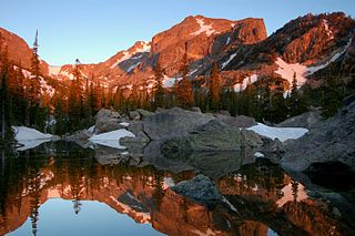
Hallett Peak is a mountain summit in the northern Front Range of the Rocky Mountains of North America. The 12,720-foot (3,877 m) peak is located in the Rocky Mountain National Park Wilderness, 10.1 miles (16.2 km) southwest by west of the Town of Estes Park, Colorado, United States, on the Continental Divide between Grand and Larimer counties.

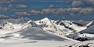
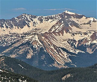
Mount Richthofen is the highest summit of the Never Summer Mountains range of the Rocky Mountains of North America. The prominent 12,945-foot (3,946 m) peak is located 5.6 miles (9.0 km) northwest by west of Milner Pass, Colorado, United States, on the Continental Divide separating the Rocky Mountain National Park Wilderness in Rocky Mountain National Park and Grand County from Routt National Forest and Jackson County. The mountain was named in honor of pioneering German geologist Baron Ferdinand von Richthofen, apparently by Clarence King's 1870 survey team.

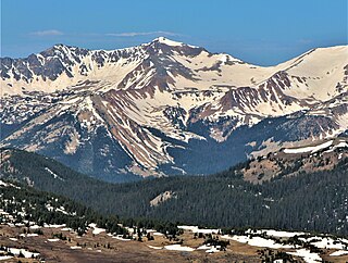
Mount Oklahoma is a high mountain summit in the Sawatch Range of the Rocky Mountains of North America. The 13,852-foot (4,222 m) thirteener is located 5.7 miles (9.2 km) northeast by north of Independence Pass, Colorado, United States, on the Continental Divide separating the Mount Massive Wilderness in San Isabel National Forest and Lake County from the Hunter-Fryingpan Wilderness in White River National Forest and Pitkin County. The mountain was named in honor of the University of Oklahoma.

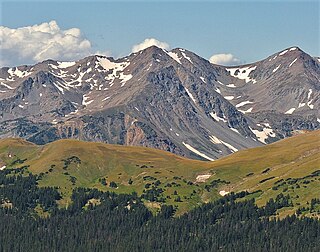
Mount Ida is a mountain summit in the northern Front Range of the Rocky Mountains of North America. The 12,874-foot (3,924 m) peak is located in the Rocky Mountain National Park Wilderness, 13.4 miles (21.6 km) west of the Town of Estes Park, Colorado, United States, on the Continental Divide between Grand and Larimer counties. The mountain was probably named after Mount Ida on Crete.

Powell Peak is a summit in Grand County, Colorado, in the United States. With an elevation of 13,176 feet (4,016 m), Powell Peak is the 493rd-highest summit in the state of Colorado.

Mount Garfield is a 13,074-foot-elevation (3,985-meter) mountain summit located in San Juan County, Colorado, United States. It is situated eight miles south of the community of Silverton, in the Weminuche Wilderness, on land managed by San Juan National Forest. It is part of the San Juan Mountains range which is a subset of the Rocky Mountains of North America. Precipitation runoff from the mountain drains into tributaries of the Animas River. The peak can be seen from U.S. Route 550 and the Durango and Silverton Narrow Gauge Railroad. Topographic relief is significant as the west aspect rises over 4,300 feet above the river and railway in approximately one mile. It is set six miles west of the Continental Divide, one mile west of Electric Peak, and three miles east-southeast of Snowdon Peak.
Mount Cirrus is a 12,808-foot-elevation (3,904-meter) mountain summit in Colorado, United States.

Mount Cumulus is a 12,729-foot-elevation (3,880-meter) mountain summit in Colorado, United States.
Mount Nimbus is a 12,721-foot-elevation (3,877-meter) mountain summit in Grand County, Colorado, United States.

Baker Mountain is a 12,410-foot-elevation (3,780-meter) mountain summit in Grand County, Colorado, United States.
Howard Mountain is a 12,826-foot-elevation (3,909-meter) summit in Colorado, United States.

Chiefs Head Peak is a 13,577-foot-elevation (4,138-meter) mountain summit in Boulder County, Colorado, United States.

Otis Peak is a 12,486-foot-elevation (3,806-meter) mountain summit on the boundary shared by Grand County and Larimer County, in Colorado, United States.

McHenrys Peak is a 13,327-foot-elevation (4,062-meter) mountain summit on the boundary shared by Grand County and Larimer County in Colorado, United States.

Sprague Mountain is a 12,713-foot-elevation (3,875-meter) mountain summit on the boundary shared by Grand County and Larimer County, in Colorado, United States. It is set on the Continental Divide in the Front Range of the Rocky Mountains, and 12.5 miles (20.1 km) west of the community of Estes Park. Precipitation runoff from the mountain's east side drains into tributaries of the Big Thompson River and the west slope drains into headwaters of Tonahutu Creek which flows to Grand Lake. Topographic relief is significant as the summit rises over 1,900 feet above Tonahutu Creek in one mile. The peak is visible from Trail Ridge Road.
Mount Stratus is a 12,534-foot-elevation (3,820-meter) mountain summit in Grand County, Colorado, United States.
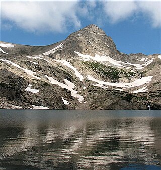
Mount Toll is a 12,979-foot (3,956 m) mountain summit on the boundary shared by Boulder County and Grand County, in Colorado, United States.

Parika Peak is a 12,402-foot-elevation (3,780-meter) mountain summit in Colorado, United States.

Never Summer Peak is a 12,452-foot-elevation (3,795-meter) mountain summit in Colorado, United States.

Green Knoll is a 12,297-foot-elevation (3,748-meter) mountain summit in Grand County, Colorado, United States.