Murray County, Minnesota

Last updated

Murray County
Murray County Government Center.JPG
Murray County Government Center in Slayton, Minnesota
Map of Minnesota highlighting Murray County.svg
Location within the U.S. state of Minnesota
Minnesota in United States.svg
Minnesota's location within the U.S.
Coordinates: 44°01′N95°46′W / 44.02°N 95.76°W / 44.02; -95.76
CountryFlag of the United States.svg United States
StateFlag of Minnesota.svg  Minnesota
FoundedMay 23 (created)
June 17, 1872 (organized)
Named for William Pitt Murray
Seat Slayton
Largest citySlayton
Area
  Total720 sq mi (1,900 km2)
  Land705 sq mi (1,830 km2)
  Water15 sq mi (40 km2)  2.1%
Population
 (2020)
  Total8,179
  Estimate 
(2023)
8,049 Decrease2.svg
  Density11.6/sq mi (4.5/km2)
Time zone UTC−6 (Central)
  Summer (DST) UTC−5 (CDT)
Congressional district 7th
Website www.murray-countymn.com

Murray County is a county in the U.S. state of Minnesota. The population was 8,179 at the 2020 census. [1] Its county seat is Slayton. [2]

Contents

History

In 1853 the Minnesota Territory legislature created Blue Earth County from unorganized Dakota Territory lands. In 1855 the legislature partitioned a portion of western Blue Earth to create Brown County. Then on May 23, 1857, a portion of Brown was partitioned off to create Murray County, although it was not organized at that time. On June 17, 1872, the county government was effected, with Currie, which had been founded that same year, as county seat. The county was named for William Pitt Murray (1825-1910), a prominent civic and political figure in Minnesota during its nascent era.

Also in 1872 the township of Center was platted (so named for its central position in the county). This settlement grew rapidly, and its residents soon began agitating to have the county seat moved there. [3] In 1882 the town was renamed as Slayton, and a county vote changed the county seat to Slayton effective June 1, 1889. [4]

In the history of record keeping, Minnesota has been struck by two F-5 tornadoes, and both occurred in Murray County: the Chandler-Lake Wilson Tornado (June 16, 1992) and the Tracy Tornado (June 13, 1968) that began in Murray County before crossing north into Lyon County.
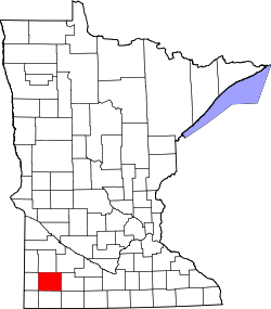
Geography

The county terrain consists of low rolling hills, dotted with lakes and ponds, with all available area devoted to agriculture. [5] The terrain slopes to the south and east. However, its highest elevation occurs on Buffalo Ridge, a promontory extending about two miles along the crest of the Coteau des Prairies in central Chanarambie Township. The bluff rises a few hundred feet above the adjacent valleys. [4] The county has a total area of 720 square miles (1,900 km2), of which 705 square miles (1,830 km2) is land and 15 square miles (39 km2) (2.1%) is water. [6]

The Mississippi-Missouri watershed divide runs through the western part of the county, near Chandler, along Buffalo Ridge. The county's highest point is on that ridge, at 1,920' ASL. [7]

Soils of Murray County Murray Co Pie Chart No Text Version.pdf
Soils of Murray County
Soils of Lake Shetek State Park area Lake Shetek State Park Wiki Version.jpg
Soils of Lake Shetek State Park area

Major highways

Airports [5]

Adjacent counties

Protected areas [5]

  • Badger Lake State Wildlife Management Area
  • Bergman State Wildlife Management Area
  • Big Slough State Wildlife Management Area
  • Buffalo Lake State Wildlife Management Area
  • Chandler State Wildlife Management Area
  • County Line State Wildlife Management Area
  • Current Lake State Wildlife Management Area
  • Great Oasis State Wildlife Management Area
  • Haberman State Wildlife Management Area
  • Hjermstad Lake State Wildlife Management Area
  • Irruption State Wildlife Management Area
  • Klinker State Wildlife Management Area
  • Lake Shetek State Park
  • Lange State Wildlife Management Area
  • Leeds State Wildlife Management Area
  • Lowville State Wildlife Management Area
  • Mason State Wildlife Management Area
  • McCord-Laible State Wildlife Management Area
  • Nelson State Wildlife Management Area
  • Northern Tallgrass Prairie National Wildlife Refuge
  • Peters State Wildlife Management Area
  • Phelan State Wildlife Management Area
  • Reinhold State Wildlife Management Area
  • Rupp State Wildlife Management Area
  • Ruthton State Wildlife Management Area
  • Schoeberl State Wildlife Management Area
  • Shetek State Wildlife Management Area
  • Sweetman State Wildlife Management Area
  • Tutt State Wildlife Management Area
  • Van Eck State Wildlife Management Area

Lakes [5]

  • Bear Lake (drained)
  • Bloody Lake
  • Buffalo Lake
  • Corabelle Lake
  • Current Lake
  • Fox Lake
  • Fulda First Lake
  • Iron Lake
  • Julia Lake (part)
  • Lake Louisa
  • Lake Maria
  • Lake Sarah
  • Lake Shetek
  • Lake Wilson
  • Lime Lake (formerly known as Lizzard Lake and Lake St. Rose) [9]
  • Long Lake (part)
  • North Badger Lake
  • Round Lake
  • Smith Lake
  • South Badger Lake
  • Summit Lake
  • Talcot Lake (part)

Demographics

Historical population
CensusPop.Note
1860 29
1870 209620.7%
1880 3,6041,624.4%
1890 6,69285.7%
1900 11,91178.0%
1910 11,755−1.3%
1920 13,63116.0%
1930 13,9022.0%
1940 15,0608.3%
1950 14,801−1.7%
1960 14,743−0.4%
1970 12,508−15.2%
1980 11,507−8.0%
1990 9,660−16.1%
2000 9,165−5.1%
2010 8,725−4.8%
2020 8,179−6.3%
2023 (est.)8,049 [10] −1.6%
U.S. Decennial Census [11]
1790-1960 [12] 1900-1990 [13]
1990-2000 [14] 2010-2020 [1]

2020 Census

Murray County Racial Composition [15]
RaceNum.Perc.
White (NH)7,48391.5%
Black or African American (NH)260.32%
Native American (NH)90.11%
Asian (NH)1051.3%
Pacific Islander (NH)30.03%
Other/Mixed (NH)1712.1%
Hispanic or Latino 3824.7%

2000 census

Age pyramid of county residents based on 2000 census data USA Murray County, Minnesota age pyramid.svg
Age pyramid of county residents based on 2000 census data

As of the census of 2000, there were 9,165 people, 3,722 households, and 2,601 families in the county. The population density was 13 per square mile (5.0/km2). There were 4,357 housing units at an average density of 6.18 per square mile (2.39/km2). The racial makeup of the county was 98.34% White, 0.10% Black or African American, 0.22% Native American, 0.21% Asian, 0.02% Pacific Islander, 0.45% from other races, and 0.67% from two or more races. 1.47% of the population were Hispanic or Latino of any race. 47.3% were of German, 12.9% Norwegian, 12.5% Dutch and 5.1% Swedish ancestry.

There were 3,722 households, out of which 29.00% had children under the age of 18 living with them, 62.50% were married couples living together, 4.60% had a female householder with no husband present, and 30.10% were non-families. 27.10% of all households were made up of individuals, and 15.30% had someone living alone who was 65 years of age or older. The average household size was 2.42 and the average family size was 2.94.

The county population contained 25.00% under the age of 18, 5.90% from 18 to 24, 23.30% from 25 to 44, 24.70% from 45 to 64, and 21.20% who were 65 years of age or older. The median age was 42 years. For every 100 females there were 98.50 males. For every 100 females age 18 and over, there were 97.00 males.

The median income for a household in the county was $34,966, and the median income for a family was $40,893. Males had a median income of $27,101 versus $19,636 for females. The per capita income for the county was $17,936. About 6.30% of families and 8.30% of the population were below the poverty line, including 8.40% of those under age 18 and 9.40% of those age 65 or over.

Communities

Cities

Census-designated place

Unincorporated communities

Townships

Government and politics

The county matched the national outcome every year from 1964 until 2008 except 1988, when during the farm crisis it voted for Michael Dukakis. However, like most other rural heavily white areas of the country, it has swung heavily Republican since 2016. In 60% of presidential elections since 1980, the county selected the Republican Party candidate (as of 2020).

United States presidential election results for Murray County, Minnesota [16]
Year Republican Democratic Third party
No.%No.%No.%
2020 3,36368.69%1,44929.60%841.72%
2016 2,97463.71%1,29527.74%3998.55%
2012 2,50452.53%2,16045.31%1032.16%
2008 2,32048.20%2,34548.72%1483.08%
2004 2,71954.40%2,21844.38%611.22%
2000 2,40750.64%2,09344.04%2535.32%
1996 1,90739.17%2,17344.63%78916.20%
1992 1,60930.87%1,99338.23%1,61130.90%
1988 2,31644.44%2,84054.49%561.07%
1984 2,78049.87%2,74149.17%540.97%
1980 3,00448.56%2,71443.87%4687.57%
1976 2,60540.71%3,68557.59%1091.70%
1972 2,95949.92%2,89348.81%751.27%
1968 2,90649.35%2,66245.21%3205.43%
1964 2,32537.79%3,82262.13%50.08%
1960 3,35752.64%3,00947.19%110.17%
1956 3,26154.61%2,69545.13%150.25%
1952 4,05465.15%2,14534.47%240.39%
1948 1,95134.83%3,59464.16%571.02%
1944 2,58550.67%2,49548.90%220.43%
1940 3,04448.46%3,20351.00%340.54%
1936 1,60127.34%3,92667.05%3285.60%
1932 1,31428.21%3,26470.07%801.72%
1928 2,60255.26%2,07844.13%290.62%
1924 2,03445.80%3347.52%2,07346.68%
1920 3,27079.16%69816.90%1633.95%
1916 1,13746.64%1,19348.93%1084.43%
1912 38817.18%77534.32%1,09548.49%
1908 1,29360.28%76235.52%904.20%
1904 1,46470.86%53725.99%653.15%
1900 1,35860.68%81636.46%642.86%
1896 1,20452.26%1,05445.75%462.00%
1892 58636.90%51732.56%48530.54%
County Board of Commissioners [17]
PositionNameDistrictNext Election
Commissioner and ChairpersonMolly MaloneDistrict 12024
CommissionerLori GunninkDistrict 22024
CommissionerDennis WelgravenDistrict 32026
CommissionerJackie MeierDistrict 42027
CommissionerDave ThinerDistrict 52024
State Legislature (2018-2020)
PositionNameAffiliationDistrict
Senate Bill Weber [18] Republican District 22
House of Representatives Joe Schomacker [19] Republican District 22A
U.S Congress (2018-2020)
PositionNameAffiliationDistrict
House of Representatives Collin Peterson [20] Democrat 7th
Senate Amy Klobuchar [21] Democrat N/A
Senate Tina Smith [22] Democrat N/A

See also

Related Research Articles

<span class="mw-page-title-main">Yellow Medicine County, Minnesota</span> County in Minnesota, United States

Yellow Medicine County is a county in the southwestern part of the U.S. state of Minnesota. Its eastern border is formed by the Minnesota River. As of the 2020 census, the population was 9,528. Its county seat is Granite Falls.

<span class="mw-page-title-main">Watonwan County, Minnesota</span> County in Minnesota, United States

Watonwan County is a county in the U.S. state of Minnesota. As of the 2020 census, the population was 11,253. Its county seat is St. James.

<span class="mw-page-title-main">Redwood County, Minnesota</span> County in Minnesota, United States

Redwood County is a county in the U.S. state of Minnesota. As of the 2020 census the population was 15,425. Its county seat is Redwood Falls, along the Redwood River near its confluence with the Minnesota River.

<span class="mw-page-title-main">Pope County, Minnesota</span> County in Minnesota, United States

Pope County is a county in the U.S. state of Minnesota. As of the 2020 census, the population was 11,308. Its county seat is Glenwood. The county was formed in 1862 and organized in 1866.

<span class="mw-page-title-main">Polk County, Minnesota</span> County in Minnesota, United States

Polk County is a county in the northwestern part of the U.S. state of Minnesota. The population was 31,192 at the 2020 census. Its county seat is Crookston, and the largest community is East Grand Forks.

<span class="mw-page-title-main">Pipestone County, Minnesota</span> County in Minnesota, United States

Pipestone County is a county in the U.S. state of Minnesota. As of the 2020 census, the population was 9,424. Its county seat is Pipestone.

<span class="mw-page-title-main">Nobles County, Minnesota</span> County in Minnesota, United States

Nobles County is a county in the U.S. state of Minnesota. As of the 2020 census, the population was 22,290. Its county seat is Worthington. Nobles County comprises the Worthington, MN Micropolitan Statistical Area.

<span class="mw-page-title-main">Morrison County, Minnesota</span> County in Minnesota, United States

Morrison County is a county in the U.S. state of Minnesota. As of the 2020 census, the population was 34,010. Its county seat is Little Falls. Camp Ripley Military Reservation occupies a significant area in north-central Morrison County.

<span class="mw-page-title-main">Martin County, Minnesota</span> County in Minnesota, United States

Martin County is a county in Minnesota, United States. As of the 2020 census, the population was 20,025. Its county seat is Fairmont.

<span class="mw-page-title-main">Mahnomen County, Minnesota</span> County in Minnesota, United States

Mahnomen County is a county in the U.S. state of Minnesota. As of the 2020 census, the population was 5,411. Its county seat is Mahnomen.

<span class="mw-page-title-main">Lyon County, Minnesota</span> County in Minnesota, United States

Lyon County is a county in the U.S. state of Minnesota. As of the 2020 census, the population was 25,269. Its county seat is Marshall.

<span class="mw-page-title-main">Le Sueur County, Minnesota</span> County in Minnesota, United States

Le Sueur County is a county located in the south central portion of the U.S. state of Minnesota. As of the 2020 census, the population was 28,674. Its county seat is Le Center.

<span class="mw-page-title-main">Kandiyohi County, Minnesota</span> County in Minnesota, United States

Kandiyohi County is a county in the U.S. state of Minnesota. As of the 2020 census, its population is 43,732. As of November 20, 1871, its county seat is Willmar.

<span class="mw-page-title-main">Jackson County, Minnesota</span> County in Minnesota, United States

Jackson County is a county in the U.S. state of Minnesota. As of the 2020 census, the population was 9,989. Its county seat is Jackson.

<span class="mw-page-title-main">Grant County, Minnesota</span> County in Minnesota, United States

Grant County is a county in the U.S. state of Minnesota. As of the 2020 census, the population was 6,074. Its county seat is Elbow Lake.

<span class="mw-page-title-main">Douglas County, Minnesota</span> County in Minnesota, United States

Douglas County is a county in the U.S. state of Minnesota. As of the 2020 census, the population was 39,006. Its county seat is Alexandria.

<span class="mw-page-title-main">Crow Wing County, Minnesota</span> County in Minnesota, United States

Crow Wing County is a county in the East Central part of the U.S. state of Minnesota. As of the 2020 census, the population was 66,123. Its county seat is Brainerd. The county was formed in 1857, and was organized in 1870.

Dovray Township is a township in Murray County, Minnesota, United States. The population was 167 at the 2000 census. Dovray is located in Southwest Minnesota on the eastern side of Murray County. It is five minutes from Currie, fifteen minutes from Lake Shetek State Park, and twenty minutes northeast of Slayton.

<span class="mw-page-title-main">Slayton, Minnesota</span> City in Minnesota, United States

Slayton is a city in and the county seat of Murray County, Minnesota, United States. The population was 2,013 at the 2020 census.

<span class="mw-page-title-main">The Lakes, Minnesota</span> Unincorporated community in Minnesota, US

The Lakes is an unincorporated community and census-designated place (CDP) in Murray County, Minnesota, United States located north of Currie and south of Garvin. The population was 590 at the 2020 census. The community is centered about Lake Shetek, the largest lake in southwestern Minnesota. The lake and the community are located in parts of four townships in Murray County: Lake Sarah, Shetek, Murray, and Mason.

References

  1. 1 2 "State & County QuickFacts". United States Census Bureau. Retrieved April 19, 2023.
  2. "Find a County". National Association of Counties. Retrieved June 7, 2011.
  3. Early W. Murray Co. MN Hist., pp. 76-77, retrieved August 3, 2007
  4. 1 2 Upham, Warren. Minnesota Geographic Names (1920), pp. 364-370 (accessed April 19, 2019)
  5. 1 2 3 4 Murray County MN Google Maps (accessed April 19, 2019)
  6. "2010 Census Gazetteer Files". United States Census Bureau. August 22, 2012. Archived from the original on September 21, 2013. Retrieved October 21, 2014.
  7. "Buffalo Ridge, Minnesota" . Retrieved June 24, 2013.
  8. Nelson, Steven (2011). Savanna Soils of Minnesota. Minnesota: Self. pp. 69-70. ISBN   978-0-615-50320-2.
  9. Murray County Minnesota - Lime Lake Archived September 28, 2007, at the Wayback Machine , retrieved August 3, 2007
  10. "Annual Estimates of the Resident Population for Counties: April 1, 2020 to July 1, 2023" . Retrieved March 18, 2024.
  11. "U.S. Decennial Census". United States Census Bureau. Retrieved October 21, 2014.
  12. "Historical Census Browser". University of Virginia Library. Retrieved October 21, 2014.
  13. "Population of Counties by Decennial Census: 1900 to 1990". United States Census Bureau. Retrieved October 21, 2014.
  14. "Census 2000 PHC-T-4. Ranking Tables for Counties: 1990 and 2000" (PDF). United States Census Bureau. Archived (PDF) from the original on March 27, 2010. Retrieved October 21, 2014.
  15. "P2 HISPANIC OR LATINO, AND NOT HISPANIC OR LATINO BY RACE – 2020: DEC Redistricting Data (PL 94-171) – Murray County, Minnesota".
  16. Leip, David. "Atlas of US Presidential Elections". uselectionatlas.org. Retrieved October 10, 2018.
  17. "Murray County, MN". www.murraycountymn.com. Retrieved April 25, 2023.
  18. "MN State Senate". www.senate.mn. Retrieved June 25, 2020.
  19. "Rep. Joe Schomacker (22A) - Minnesota House of Representatives". www.house.leg.state.mn.us. Retrieved June 17, 2022.
  20. "Congressman Collin Peterson". Congressman Collin Peterson. Archived from the original on June 25, 2020. Retrieved June 24, 2020.
  21. "U.S. Senator Amy Klobuchar". www.klobuchar.senate.gov. Retrieved June 24, 2020.
  22. "Home". Senator Tina Smith. Retrieved June 24, 2020.

44°01′N95°46′W / 44.02°N 95.76°W / 44.02; -95.76