New Town, Missouri

Last updated
This article is about the community in St. Charles County, for the town located in Sullivan County, see: Newtown, Missouri.
New Town at St. Charles, Missouri
Lakeviewhouses.jpg
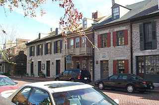
Lakeside houses in New Town
Coordinates: 38°50′12″N90°29′41″W / 38.83656°N 90.49471°W / 38.83656; -90.49471 Coordinates: 38°50′12″N90°29′41″W / 38.83656°N 90.49471°W / 38.83656; -90.49471
Country United States
State Missouri
County St. Charles
Elevation
439.6 ft (134 m)
Time zone UTC-6 (CST)
  Summer (DST) UTC-5 (CDT)
Area code(s) 636
Website www.newtownatstcharles.com

New Town at St. Charles is a neighborhood within the city of St. Charles, Missouri. The community was developed with the principles of Traditional Neighborhood Design and New Urbanism. [1]

St. Charles, Missouri Place in Missouri, United States

Saint Charles is a city in, and the county seat of, St. Charles County, Missouri, United States. The population was 65,794 at the 2010 census, making St. Charles the ninth-largest city in Missouri. Situated on the Missouri River, it is a northwestern suburb of St. Louis.

New Urbanism urban design movement promoting environmentally friendly habits

New Urbanism is an urban design movement which promotes environmentally friendly habits by creating walkable neighborhoods containing a wide range of housing and job types. It arose in the United States in the early 1980s, and has gradually influenced many aspects of real estate development, urban planning, and municipal land-use strategies.

Contents

Environment

New Town is located in northeastern St. Charles County, approximately 18 miles (29 km) from the confluence of the Missouri and Mississippi rivers. New Town was built on a small natural ridge and is surrounded by low farmland and wetland. The area is home to many species of ducks, [2] cranes, geese, snakes, deer, fish, hawks, and eagles. The Great Rivers Greenway District and Katy Trail State Park both run close by New Town and provide residents access to wildlife.[ citation needed ]

St. Charles County, Missouri County in the United States

St. Charles County is in the central eastern part of the U.S. state of Missouri. As of the 2010 census, the population was 360,485, making it Missouri's third-most populous county. Its county seat is St. Charles. The county was organized October 1, 1812 and named for Saint Charles Borromeo, an Italian cardinal. The county executive is Steve Ehlmann, since January 2007.

Confluence Meeting of two or more bodies of flowing water

In geography, a confluence occurs where two or more flowing bodies of water join together to form a single channel. A confluence can occur in several configurations: at the point where a tributary joins a larger river ; or where two streams meet to become the source of a river of a new name ; or where two separated channels of a river rejoin at the downstream end.

Missouri River major river in the central United States, tributary of the Mississippi

The Missouri River is the longest river in North America. Rising in the Rocky Mountains of western Montana, the Missouri flows east and south for 2,341 miles (3,767 km) before entering the Mississippi River north of St. Louis, Missouri. The river drains a sparsely populated, semi-arid watershed of more than 500,000 square miles (1,300,000 km2), which includes parts of ten U.S. states and two Canadian provinces. Although nominally considered a tributary of the Mississippi, the Missouri River above the confluence is much longer and carries a comparable volume of water. When combined with the lower Mississippi River, it forms the world's fourth longest river system.

People standing on a dock at one of the swimming lakes of New Town NewTownLakeSwimming.jpg
People standing on a dock at one of the swimming lakes of New Town

In 1993, the Midwest experienced the most severe flood in recent history, and much of St. Charles County was underwater. Because of its higher elevation, little flooding occurred on the future site of New Town. Nevertheless, New Town's developers built a series of lakes and canals for drainage and used the excavated dirt to raise the site's elevation by several feet.[ citation needed ]

History

Young residents lead off the New Town, St. Charles July 4th parade July4thParadeNewTown-1.jpg
Young residents lead off the New Town, St. Charles July 4th parade

Greg Whittaker of Whittaker Builders, Inc., [3] the architectural firm of Duany Plater-Zyberk & Company, and the City of St. Charles conducted a public charrette to design New Town in February 2003. A community incorporating a wide range of housing types, parks and greens, an organic farm, and a total of six neighborhood centers was planned. Construction began in 2004, and the first residents arrived in April 2005.[ citation needed ] When complete, New Town will cover 755 acres (3.06 km2), will contain up to 5,700 dwellings, and will be one of the largest new urbanist communities in the United States. It is expected to take 12 to 15 years to complete. [4]

A charrette, often Anglicized to charette or charet and sometimes called a design charrette, is an intense period of design or planning activity.

Village green common open area within a settlement

A village green is a common open area within a village or other settlement. Traditionally, a village green was common grassland at the centre of a rural settlement used for grazing with a pond for watering cattle and other stock.

Economics

In addition to the residential and recreational development, the planned community includes commercial space and currently has a few small businesses, restaurants, cafés. The community is also the headquarters of Whittaker Builders, Inc. [3] In October 2009, Whittaker Builders filed for Chapter 11 bankruptcy. [5]

Transportation

The New Town settlement is located near Missouri Route 370, an east-west freeway connecting St. Peters, St. Charles and northern St. Louis County.

Missouri Route 370 (Route 370) is a freeway that connects St. Louis County with St. Charles County via the Discovery Bridge over the Missouri River.

St. Peters, Missouri City

St. Peters is a city in St. Charles County, Missouri, United States. The 2010 census showed the city's population to be 52,575, tied for 10th place in Missouri with Blue Springs.

St. Louis County, Missouri County in the United States

St. Louis County is located in the far eastern portion of the U.S. state of Missouri. It is bounded by the city of St. Louis and the Mississippi River to the east, the Missouri River to the north, and the Meramec River to the south. As of the 2016 Census Bureau population estimate, the population was 998,581, making it the most populous county in Missouri. Its county seat is Clayton.

New Town is also a planned stop for the St. Charles Streetcar project, a future heritage streetcar line. A planned 8-mile (13 km) route connecting New Town, the historic downtown of St. Charles city, the St. Charles Convention Center, and the Family Arena sports and performance arena. [6]

References

  1. http://www.newurbannews.com/NewTownInsideJul05.html
  2. Rushton, Bruce (2002-11-27). "Odd Ducks". Riverfront Times. Retrieved 2010-01-09.
  3. 1 2 Trask, Mike (2009). "Whittaker Builders continues to sell New Town in St. Charles City". Missouri Lawyers Media.
  4. http://www.southernliving.com/travel/south-west/new-town-st-charles-st-louis-missouri-00400000046775/
  5. Garrison, Chad (October 19, 2009). "New Town Developer Files Bankruptcy; Whittaker Homes Plans to Reorganize". Riverfront Times. Retrieved March 23, 2019.
  6. "Archived copy". Archived from the original on 2009-12-12. Retrieved 2010-06-25.CS1 maint: Archived copy as title (link)