North Tustin, California Tustin Foothills (until 2005) | |
---|---|
Clockwise from top: Fairmont Private Schools campus, Foothill High School gym, Manassero Farms | |
Coordinates: 33°45′54″N117°47′57″W / 33.76500°N 117.79917°W | |
Country | United States |
State | California |
County | Orange |
Area | |
• Total | 6.673 sq mi (17.284 km2) |
• Land | 6.673 sq mi (17.284 km2) |
• Water | 0 sq mi (0 km2) 0% |
Elevation | 256 ft (78 m) |
Population | |
• Total | 25,718 |
• Density | 3,900/sq mi (1,500/km2) |
Time zone | UTC-8 (PST) |
• Summer (DST) | UTC-7 (PDT) |
ZIP code | 92705, 92780 |
Area code | 714 |
FIPS code | 06-52379 |
GNIS feature IDs | 1867065, 2408951 |
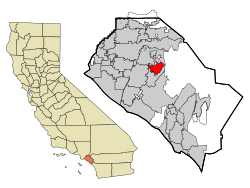
North Tustin [4] is an unincorporated community and census designated place (CDP) in Orange County, California. The population was 25,718 at the 2020 census, up from 24,917 in 2010. For statistical purposes, the United States Census Bureau has defined North Tustin as a census-designated place (CDP). It is both the largest CDP and largest unincorporated community in Orange County. The CDP's name was changed from Tustin Foothills in 2005. Located outside the city limits of Tustin, North Tustin has 92705 and 92780 ZIP Codes.
According to the United States Census Bureau, the CDP has a total area of 6.7 square miles (17 km2), all of it land.
North Tustin is bordered by the city of Tustin to the south, east, and west, and by the city of Orange to the north.
Within North Tustin are the distinct unincorporated communities of Cowan Heights, East Tustin, Lemon Heights, North Tustin, Panorama Heights, and Red Hill[ citation needed ]. While there is no local government authority, some social and community services are provided by The Foothill Communities Association (FCA), a nonprofit corporation begun in the 1960s to preserve the living environment in those communities. [5] FCA also advocates for or against some development projects within the North Tustin area depending on the impact on the community.
Census | Pop. | Note | %± |
---|---|---|---|
1970 | 26,598 | — | |
1980 | 26,174 | −1.6% | |
1990 | 24,358 | −6.9% | |
2000 | 24,044 | −1.3% | |
2010 | 24,917 | 3.6% | |
2020 | 25,718 | 3.2% | |
U.S. Decennial Census [6] 1850–1870 [7] [8] 1880-1890 [9] 1900 [10] 1910 [11] 1920 [12] 1930 [13] 1940 [14] 1950 [15] 1960 [16] 1970 [17] 1980 [18] 1990 [19] 2000 [20] 2010 [21] |
North Tustin first appeared as an unincorporated community in the 1970 U.S. Census under the name Tustin Foothills; [17] and designated as a census designated place in the 1980 U.S. Census. [18] The name was changed to North Tustin for the 2010 U.S. Census. [21]
The 2010 United States Census [22] reported that North Tustin had a population of 24,917. The population density was 3,733.7 inhabitants per square mile (1,441.6/km2). The racial makeup of North Tustin was 20,836 (83.6%) White (75.4% Non-Hispanic White), [23] 148 (0.6%) African American, 104 (0.4%) Native American, 1,994 (8.0%) Asian, 52 (0.2%) Pacific Islander, 908 (3.6%) from other races, and 875 (3.5%) from two or more races. Hispanic or Latino of any race were 3,260 persons (13.1%).
The Census reported that 24,726 people (99.2% of the population) lived in households, 161 (0.6%) lived in non-institutionalized group quarters, and 30 (0.1%) were institutionalized.
There were 8,580 households, out of which 3,036 (35.4%) had children under the age of 18 living in them, 5,971 (69.6%) were opposite-sex married couples living together, 685 (8.0%) had a female householder with no husband present, 310 (3.6%) had a male householder with no wife present. There were 200 (2.3%) unmarried opposite-sex partnerships, and 69 (0.8%) same-sex married couples or partnerships. 1,276 households (14.9%) were made up of individuals, and 764 (8.9%) had someone living alone who was 65 years of age or older. The average household size was 2.88. There were 6,966 families (81.2% of all households); the average family size was 3.19.
The population was spread out, with 5,857 people (23.5%) under the age of 18, 1,709 people (6.9%) aged 18 to 24, 4,613 people (18.5%) aged 25 to 44, 7,979 people (32.0%) aged 45 to 64, and 4,759 people (19.1%) who were 65 years of age or older. The median age was 45.6 years. For every 100 females, there were 96.3 males. For every 100 females age 18 and over, there were 94.0 males.
There were 8,866 housing units at an average density of 1,328.5 per square mile (512.9/km2), of which 7,676 (89.5%) were owner-occupied, and 904 (10.5%) were occupied by renters. The homeowner vacancy rate was 0.9%; the rental vacancy rate was 3.4%. 22,095 people (88.7% of the population) lived in owner-occupied housing units and 2,631 people (10.6%) lived in rental housing units.
According to the 2010 United States Census, North Tustin had a median household income of $119,207, with 3.0% of the population living below the federal poverty line. [23]
As of the census [24] of 2000, there were 24,044 people, 8,269 households, and 6,945 families residing in the CDP. The population density was 3,590.5 inhabitants per square mile (1,386.3/km2). There were 8,417 housing units at an average density of 1,256.9 per square mile (485.3/km2). The racial makeup of the CDP was 86.80% White, 0.56% African American, 0.36% Native American, 7.05% Asian, 0.13% Pacific Islander, 2.62% from other races, and 2.48% from two or more races. Hispanic or Latino of any race were 8.47% of the population.
There were 8,269 households, out of which 34.9% had children under the age of 18 living with them, 74.2% were married couples living together, 7.0% had a female householder with no husband present, and 16.0% were non-families. 11.9% of all households were made up of individuals, and 6.7% had someone living alone who was 65 years of age or older. The average household size was 2.89 and the average family size was 3.12.
In the CDP, the population was spread out, with 25.0% under the age of 18, 5.4% from 18 to 24, 24.6% from 25 to 44, 28.2% from 45 to 64, and 16.8% who were 65 years of age or older. The median age was 42 years. For every 100 females, there were 96.6 males. For every 100 females age 18 and over, there were 94.4 males.
The median income for a household in the CDP is one of the highest in Orange County and was $96,230, and the median income for a family was $103,257. Males had a median income of $71,688 versus $42,785 for females. The per capita income for the CDP was $42,656. About 2.2% of families and 3.3% of the population were below the poverty line, including 3.2% of those under age 18 and 1.9% of those age 65 or over.
In the California State Legislature, North Tustin is in the 37th Senate District , represented by Republican Steven Choi, and in the 59th Assembly District , represented by Republican Phillip Chen. [25]
In the United States House of Representatives, North Tustin is in California's 40th congressional district , represented by Republican Young Kim. [26]
Primary and secondary education is overseen by the Tustin Unified School District (which also serves the incorporated City of Tustin It has one of the highest accelerated learning percentages in the US.
Orange Unified School District, which also serves the incorporated City of Orange, CA, serves Unincorporated North Tustin in the Panorama Heights and Crawford Canyon neighborhoods North of Fairhaven Extension. https://www.orangeusd.org/our-schools/school-locator-maps
Bowles is a census-designated place (CDP) in Fresno County, California, United States. The population was 166 at the 2010 census, down from 182 at the 2000 census. Bowles is located 11 miles (18 km) south of downtown Fresno, at an elevation of 279 feet.
Bodfish is a census-designated place (CDP) in the southern Kern River Valley of the Southern Sierra Nevada, in Kern County, California, United States.
Alondra Park, also known as El Camino Village, is a census designated place (CDP) in the South Bay region of Los Angeles County, California, United States. It is the unincorporated area north of Alondra Community Regional Park and El Camino College. It is east of Lawndale, south of Hawthorne, west of Gardena, and north of Torrance. Manhattan Beach Boulevard and Crenshaw Boulevard are the two major cross streets in the area. The population was 8,569 at the 2020 census, down from 8,592 at the 2010 census. There is an official Alondra Park Post Office of the U.S. Postal Service in nearby Gardena, California. Urbanized cement-lined Dominguez Creek bisects a portion of Alondra Park.
Citrus is a census-designated place (CDP) in Los Angeles County, California, United States. It is located in the San Gabriel Valley between Azusa to the north and west, Glendora to the east, and Covina to the south.
Desert View Highlands is a census-designated place (CDP) in Los Angeles County, California, United States. The population was 2,360 at the 2010 census, up from 2,337 at the 2000 census. It is surrounded by the City of Palmdale.
East Rancho Dominguez, also known as East Compton, is an unincorporated community and census-designated place (CDP) located in southern Los Angeles County, California. The population was 15,135 at the 2010 census, up from 9,286 at the 2000 census. East Rancho Dominguez is an accepted city name according to the USPS, and shares the 90221 ZIP Code with Compton.
East Whittier is an unincorporated community in Los Angeles County, California, United States. The population was 9,757 at the 2010 census, up from 9,538 at the 2000 census. For statistical purposes, the United States Census Bureau has defined this community as a census-designated place (CDP). The name was changed from East La Mirada in 2012, likely due to its precise location in relation to the city of Whittier.
East Pasadena is an unincorporated community in Los Angeles County, California, United States. The population was 6,021 at the 2020 census, down from 6,144 at the 2010 census. For statistical purposes, the United States Census Bureau has defined East Pasadena as a census-designated place (CDP).
East San Gabriel is a census-designated place (CDP) in Los Angeles County, California, United States. The population was 14,874 at the 2010 census, up from 14,512 at the 2000 census.
Florence-Graham is a census-designated place in Los Angeles County, California. The population was 61,983 at the 2020 census, down from 63,387 at the 2010 census. The census area includes separate communities of Florence, Firestone Park, and Graham. It is located in the south central region of Los Angeles County. The neighboring communities are Central-Alameda, Florence, Green Meadows, Lynwood, Vernon, Walnut Park, Watts, and Compton.
Aromas is an unincorporated community and census-designated place (CDP) in Monterey County and San Benito County, California, United States. The population was 2,708 at the 2020 census.
Bradley is an unincorporated community and census-designated place (CDP) in Monterey County, California, on the Salinas River 14 miles (23 km) south-southeast of San Ardo and 20 miles (32 km) north of Paso Robles. Bradley sits at an elevation of 548 feet (167 m). The population was 69 at the 2020 census, down from 93 at the 2010 census.
Big River is a census-designated place (CDP) in San Bernardino County, California, United States. The population was 1,084 at the 2020 census, down from 1,327 at the 2010 census.
Bloomington is an urban unincorporated community in San Bernardino County, California, United States. The population was 23,851 at the 2010 census, up from 19,318 at the 2000 census. For statistical purposes, the United States Census Bureau has defined Bloomington as a census-designated place (CDP).
Bonsall is a census-designated place (CDP) in San Diego County, California. The population was 3,982 at the 2010 census, up from 3,401 at the 2000 census.
Camp Pendleton Mainside is a census-designated place (CDP) in San Diego County, California, located at the southeast corner of Marine Corps Base Camp Pendleton. Per the 2020 census, the population was 9,683. It was formerly known as Camp Pendleton North, but its name was changed for the 2020 Census. Along with Camp Pendleton South, it is one of two CDPs located on the base.
Camp Pendleton South is a census-designated place (CDP) in San Diego County, California, located at the southwest corner of the Marine Corps Base Camp Pendleton. The population was 10,616 at the 2010 census, up from 8,854 at the 2000 census. Much of the population are residents of Camp Pendleton barracks situated in the area, as well as housing communities for married Marine and Navy personnel and their families. It, along with Camp Pendleton Mainside, is one of two CDPs on the base.
Cottonwood is a census-designated place (CDP) in Shasta County, California, United States. Its population is 6,268 as of the 2020 census, up from 3,316 from the 2010 census. Cottonwood was a stagecoach town where a settlement was established in 1849. The first Post Office was opened in 1852. Cottonwood is equidistant between Redding and Red Bluff, 15 miles (24 km) in either direction. It is 4 miles (6.4 km) south of Anderson.
North Escobares is a census-designated place (CDP) in Starr County, Texas, United States. The population was 162 at the 2020 census.
Rossmoor is a planned census-designated place located in Orange County, California. As of the 2020 census, the CDP had a total population of 10,625 up from the 2010 census population of 10,244. The gated Leisure World retirement community in the city of Seal Beach is to the south of Rossmoor, Los Alamitos is to the east and north, and Long Beach is to the west. The community of Rossmoor has two shopping centers within its boundaries, but only one—the Rossmoor Village Square, is now within the political boundaries of Rossmoor. A larger shopping center, the Rossmoor Business Center, was annexed, despite many protests, by the City of Seal Beach in 1967. The Center has been remodeled several times and was renamed the Shops at Rossmoor in the early 2000s.