Tam O'Shanter-Sullivan

Last updated

Tam O'Shanter-Sullivan
Neighbourhood
Tam O'Shanter - Sullivan aerial view 2023.jpg
Aerial view of Tam O'Shanter-Sullivan in 2023
Tam O'Shanter-Sullivan map.PNG
Sullivan is west of Warden while Tam O'Shanter is east
Coordinates: 43°47′17″N79°18′05″W / 43.78806°N 79.30139°W / 43.78806; -79.30139
CountryFlag of Canada (Pantone).svg  Canada
ProvinceFlag of Ontario.svg  Ontario
City Toronto
Established1850 Scarborough Township
Changed municipality1998 Toronto from City of Scarborough
Government
   MP Jean Yip (Scarborough—Agincourt)
   MPP Aris Babikian (Scarborough—Agincourt)
   Councillor Nick Mantas (Ward 22 Scarborough—Agincourt)

Tam O'Shanter-Sullivan is a neighbourhood in the east end of the city of Toronto, Ontario, Canada, in the district of Scarborough. The neighbourhood is bordered by Huntingwood Drive to the North, Kennedy Road to the East, Highway 401 to the South and Victoria Park (and Pharmacy Ave) to the West. The neighbourhood, which includes the Tam O'Shanter (east of Warden) and Sullivan (west of Warden) communities, takes its name from Tam O’Shanter Golf Course and O'Sullivan's Corners.

Contents

The neighbourhood is sometimes included as part of the neighbourhood of Agincourt, which borders Tam O'Shanter to the east. Both regions are part of the electoral district of Scarborough—Agincourt, and the Agincourt Mall is located in Tam O'Shanter.

History

Sullivan community

O'Sullivan's Corners, located at the corner of Victoria Park and Sheppard Avenues, was named after Patrick O'Sullivan, and consisted of a hotel and a post office, which opened in 1892. The post office was closed in 1912, but reopened in 1956 in the drug store in Wishing Well Plaza at the south-east corner of Pharmacy and Sheppard, as a result of the residential developments in the area. A gas station used to be located here along with a hamburger restaurant, Johnny's Hamburgers, which still stands to this day. A new retail development has been built around Johnny's.

The first subdivision in the neighbourhood, "Town and Country" was bordered by Victoria Park Avenue, Sheppard Avenue, Pharmacy and Ontario Highway 401 (then known as the Toronto By-Pass), or the north part of Lot 35, Concession II, Scarborough Township. The land had been farmed by Thomas Mason. [1] Town and Country was not connected to the sewer system, and the houses all had their own septic systems. The headwaters of Taylor-Massey Creek ran underground through the subdivision, above ground through Wishing Well Park, and under Highway 401. With the widening of the 401, the above-ground portion of the creek was buried and the headwaters were rerouted to Highland Creek.

The next subdivision, "Wishing Well Acres" was east of Pharmacy on the north part of Lots 33 and 34, Concession II, which had been farmed by Christopher Thomson and Ichabod Vradenburg(h) in the 1870s. [2] [3] The neighbourhood school and the street it is on were named after the Vradenburgs, although the spelling of the street name has been inexplicably changed. Wishing Well Acres was the site of the millionth home built in Canada after World War I. Famous residents of the area include Brad Park and Mike Levine of Triumph.

Bridlewood community

View of the neighbourhood near Holy Spirit Roman Catholic Church Holy Spirit, Toronto.JPG
View of the neighbourhood near Holy Spirit Roman Catholic Church

From 1927 to 1946, Harry C. Hatch raised and trained five King's Plate winners on his farm at the northeast corner of Pharmacy and Sheppard, including Monsweep (1936), Goldlure(1937), Budpath(1941), Acara(1944) and Uttermost(1945).

The farm, and others in the area, was purchased by the Robert McClintock Company for residential development of Bridlewood in the 1960s. The development was named "Bridlewood" in honor of Hatch's covered racetrack on the farm. [4] McClinkock's company was awarded the Ontario Urban Development Institute Award for the finest development of the year for Bridlewood Phase I in 1964 and Phase II in 1966. Famous residents of Bridlewood include Mike Myers, whose Wayne's World character was inspired by growing up in the area, Eric McCormack ( Will & Grace ), and David Furnish, who all attended Bridlewood Public School.

Bridlewood Mall is located outside of the community to the northwest in L'Amoreaux.

Education

Stephen Leacock Collegiate Institute is a public secondary school located in the neighbourhood. Stephen Leacock Collegiate Institute.JPG
Stephen Leacock Collegiate Institute is a public secondary school located in the neighbourhood.

Two public school boards operate schools in the neighbourhood, the separate Toronto Catholic District School Board (TCDSB), and the secular Toronto District School Board (TDSB).

TCDSB operates one public elementary school, Holy Spirit Catholic School; whereas TDSB operates several schools in the neighbourhood including one public secondary school, Stephen Leacock Collegiate Institute, and several elementary schools. TDSB elementary schools include:

TCDSB does not operate a secondary school in the neighbourhood, with TCDSB secondary school students residing in the neighbourhood attending institutions in adjacent neighbourhoods. The French-first language public secular school board, Conseil scolaire Viamonde, and it separate counterpart, Conseil scolaire catholique MonAvenir also offer schooling to applicable residents of Morningside, although they do not operate a school in the neighbourhood, with CSCM/CSV students attending schools situated in other neighbourhoods in Toronto.

Recreation

Agincourt branch of the Toronto Public Library is situated in the neighbourhood. Agincourt Library exterior, October 2018 (2).jpg
Agincourt branch of the Toronto Public Library is situated in the neighbourhood.

Several parks are situated in the neighbourhood, including Bridlewood Park, Inglewood Heights Park, Ron Watson Park, Vradenburg Park, and Wishing Well Park. Municipal parks in the neighbourhood are managed by the Toronto Parks, Forestry and Recreation Division. The neighbourhood is also home to one branch of the Toronto Public Library, Agincourt branch.

Related Research Articles

<span class="mw-page-title-main">Bendale</span> Neighbourhood in Toronto, Ontario, Canada

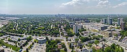
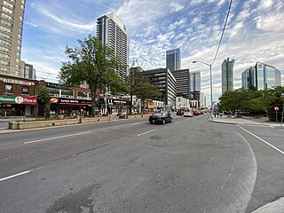
Bendale, also called Cedarbrae and Midland Park, is a residential neighbourhood in the eastern part of Toronto, Ontario, Canada. It is located in the former suburb of Scarborough. It is centred on the intersection of Lawrence Avenue East and Brimley Road. Its boundaries, as defined by the City, are Midland Avenue from Lawrence, north to Highway 401, east to McCowan, south to Lawrence, east to West Highland Creek, south-west along West Highland Creek, then follow several side streets parallel to the Creek, north to Midland Avenue. The area north of Ellesmere is typically considered the Scarborough City Centre district, and is not considered in this neighbourhood article.

<span class="mw-page-title-main">Agincourt, Toronto</span> Neighbourhood in Toronto, Ontario, Canada

Agincourt is a neighbourhood and former village in Toronto, Ontario, Canada. Agincourt is located in northeast Toronto, along Sheppard Avenue between Kennedy and Markham Roads. Before the creation of the "megacity" of Toronto in 1998, the area was part of Scarborough. It is officially recognized by the City of Toronto as occupying the neighbourhoods of Agincourt South–Malvern West and Agincourt North.

<span class="mw-page-title-main">Malvern, Toronto</span> Neighbourhood in Toronto, Ontario, Canada

Malvern is a neighbourhood in the city of Toronto, Ontario, Canada, with a population of 44,315. It is located in the northeast corner of the city.

<span class="mw-page-title-main">Willowdale, Toronto</span> Neighbourhood in Toronto, Ontario, Canada

Willowdale is a neighbourhood in the city of Toronto, Ontario, Canada, located in the district of North York. It developed from three postal villages: Newtonbrook, Willowdale and Lansing.

<span class="mw-page-title-main">Henry Farm</span> Neighbourhood in Toronto, Ontario, Canada

Henry Farm is a neighbourhood in the City of Toronto, Ontario, Canada. It is located in the north central part of the city within the former city of North York.

<span class="mw-page-title-main">Scarborough—Agincourt (federal electoral district)</span> Federal electoral district in Ontario, Canada

Scarborough—Agincourt is a federal electoral district in Toronto, Ontario, Canada that has been represented in the House of Commons of Canada since 1988. It covers the area of the City of Toronto bounded by Steeles Avenue East to the north, Highway 401 to the south, Victoria Park Avenue to the west, and Midland Avenue to the east.

<span class="mw-page-title-main">Richview, Toronto</span> Neighbourhood in Toronto, Ontario, Canada

Richview, formally known as Willowridge-Martingrove-Richview, is a neighbourhood in the city of Toronto, Ontario, Canada. It is bounded on the west by Highway 401 and on the north by the highway and by Dixon Road, Royal York Road on the east, and Eglinton Avenue West along the south. Richview was originally established as a postal village within the then-agricultural Etobicoke Township, which later became the suburb of Etobicoke.

<span class="mw-page-title-main">Milliken, Ontario</span> Neighbourhood in Ontario, Canada

Milliken and Milliken Mills are neighbourhoods in the cities of Toronto and Markham. Milliken is situated in the north west section of Scarborough, whereas Milliken Mills is situated in the south-central portions of Markham. The neighbourhoods are centered on Kennedy Road and Steeles Avenue, the latter street serving as the boundary between the cities of Markham and Toronto.

<span class="mw-page-title-main">Clanton Park, Toronto</span> Neighbourhood in Toronto, Ontario, Canada

Clanton Park is a neighbourhood in Toronto, Ontario, Canada. Located in the district of North York, it is part of federal and provincial electoral district York Centre, and Toronto electoral wards 9: York Centre (West) and 10: York Centre (East). In 2016, it had a population of 16,472, a 12.7% rise from 2011.

<span class="mw-page-title-main">Pleasant View, Toronto</span> Neighbourhood in Toronto, Ontario, Canada

Pleasant View is a neighbourhood in the city of Toronto, Ontario, Canada that is located in the district of North York at the northern end of the city. It is bordered by Victoria Park to the East, Sheppard Avenue to the South, Highway 404 to the west and the Finch hydro corridor to the north. The neighbourhood is home to several high-rise apartment and condominium buildings, such as The Clippers.

<span class="mw-page-title-main">Don Valley Village</span> Neighbourhood in Toronto, Ontario, Canada

Don Valley Village is a neighbourhood in the city of Toronto, Ontario, Canada. It is located in the former suburb of North York. Located north of Highway 401 and bisected by Don Mills Road, it is bounded by Sheppard Avenue to the south, Leslie Street to the west, Finch Avenue to the north and Highway 404 to the east. Like the nearby Don River Valley, the neighbourhood has hill and dale topography.

<span class="mw-page-title-main">Steeles, Toronto</span> Neighbourhood in Toronto, Ontario, Canada

Steeles is a suburban neighbourhood in Toronto, Ontario, Canada. Steeles is located in the north-eastern part of Toronto in the former suburb of Scarborough. To the north is bordered by Steeles Avenue East, to the east by Kennedy Road, to the south by a hydro-electric transmission line and to the west by Victoria Park Avenue.

<span class="mw-page-title-main">L'Amoreaux</span> Neighbourhood in Toronto, Ontario, Canada

L'Amoreaux is a neighbourhood in Toronto, Ontario, Canada, situated east of Victoria Park Avenue, south of McNicoll Avenue, west of Kennedy Road and north of Huntingwood Drive. L'Amoreaux is named after Josue L'Amoreaux (1738–1834), a French Huguenot loyalist who settled in the area. Prior to the amalgamation of Toronto in 1998, L'Amoreaux was a neighbourhood of the former city of Scarborough, and prior to the amalgamation of municipalities, it formed part of the town of Agincourt.

<span class="mw-page-title-main">Dorset Park</span> Neighbourhood in Toronto, Ontario, Canada

Dorset Park is a neighbourhood in Toronto, Ontario, Canada. It is located in the western part of the district of Scarborough. The neighbourhood is bordered by Highway 401 to the north, Midland Avenue to the east, Lawrence Avenue to the south, and Birchmount Road to the west. Kennedy Road runs along the neighbourhood's centre north and south and Ellesmere Road runs along the centre east and west. The area south of Lawrence Avenue, north of the hydro corridor, is known as McGregor Park and is often included as part of Dorset Park.

<span class="mw-page-title-main">Morningside, Toronto</span> Neighbourhood in Toronto, Ontario, Canada

Morningside, also known as Seven Oaks, is a suburban neighbourhood in the city of Toronto, Ontario, Canada. It is located to the north-east of downtown Toronto, in the suburb of Scarborough. Morningside is bordered by Highway 401 to the north, Morningside Avenue to the east, West Highland Creek and Lawrence Avenue to the south and Scarborough Golf Club Road to the west.

<span class="mw-page-title-main">Woburn, Toronto</span> Neighbourhood in Toronto, Ontario, Canada

Woburn is a neighbourhood located in eastern Toronto, Ontario, Canada, in the former suburb of Scarborough. Woburn is bordered by Highway 401 to the north, Orton Park Road to the east, Lawrence Avenue to the south, and McCowan Road to the west.

Bridlewood can refer to:

<span class="mw-page-title-main">Highland Creek, Toronto</span> Neighbourhood in Toronto, Ontario, Canada

Highland Creek is a neighbourhood in eastern Toronto, Ontario, Canada. It is located along the southern portion of the river of the same name in the former suburb of Scarborough. To the east are the neighbourhoods of Port Union and West Rouge, to the west West Hill and Woburn, and to the south Centennial Scarborough.

West Highland Creek is a river in Toronto, Ontario, Canada, and is a tributary of Highland Creek in the Lake Ontario drainage basin. The creek and its tributaries are entirely within the old City of Scarborough, and provide the watershed for the northwest of the city.

<span class="mw-page-title-main">Scarborough Board of Education</span> Board of Education for the City of Scarborough

The Scarborough Board of Education, formally the Board of Education for the City of Scarborough is the former public-secular school district serving Scarborough, Ontario, Canada. The board was founded in 1954 through a merger of the Scarborough Collegiate and Township School Boards.

References

  1. http://digital.library.mcgill.ca/countyatlas/showmap.php?Township=Scarboro&plotX=148&plotY=1289&getMap.x=93&getMap.y=11
  2. http://digital.library.mcgill.ca/countyatlas/showmap.php?Township=Scarboro&plotX=249&plotY=1287&getMap.x=89&getMap.y=19
  3. http://digital.library.mcgill.ca/countyatlas/showmap.php?Township=Scarboro&plotX=334&plotY=1291&getMap.x=75&getMap.y=21
  4. "Street Names of Scarborough". Scarborough Historical Society. Retrieved 19 May 2017.