
Wollongong, colloquially referred to as The Gong, is a city located in the Illawarra region of New South Wales, Australia. The name is believed to originate from the Dharawal language, meaning either 'five islands/clouds', 'ground near water' or 'sound of the sea'. Wollongong lies on the narrow coastal strip between the Illawarra Escarpment and the Pacific Ocean, 85 kilometres south of central Sydney. Wollongong had an estimated urban population of 302,739 at June 2018, making it the third-largest city in New South Wales after Sydney and Newcastle and the tenth-largest city in Australia by population. The city's current Lord Mayor is Gordon Bradbery AM who was elected in 2021.

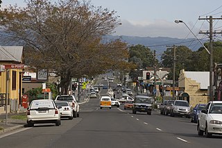
Kiama is a coastal country town 120 kilometres south of Sydney in the Illawarra. One of the main tourist attractions is the Kiama Blowhole. Kiama features several popular surfing beaches and caravan parks, and numerous alfresco cafes and restaurants. Its proximity to the south of Sydney makes it an attractive destination for many day-trippers and weekenders. Kiama also has historically been a farming and agricultural centre. Even to today it maintains a country and agricultural community with a weekly farmers markets held on Wednesday afternoons.

Arncliffe is a suburb in southern Sydney, in the state of New South Wales, Australia. Arncliffe is located 11 kilometres south of the Sydney central business district, in the local government area of the Bayside Council.

Bulli is a northern suburb of Wollongong situated on the south coast of New South Wales, Australia.

Surry Hills is an inner-east suburb of Sydney, in the state of New South Wales, Australia. Surry Hills is immediately south-east of the Sydney central business district in the local government area of the City of Sydney. Surry Hills is surrounded by the suburbs of Darlinghurst to the north, Chippendale and Haymarket to the west, Moore Park and Paddington to the east and Redfern to the south. It is often colloquially referred to as "Surry".

The Illawarra is a coastal region in the southeast of the Australian state of New South Wales. It is situated immediately south of Sydney and north of the South Coast region. It encompasses the two cities of Wollongong, Shellharbour and the coastal town of Kiama. Wollongong is the largest city of the Illawarra with a population of 240,000, then Shellharbour with a population of 70,000 and Kiama with a population of 10,000. These three cities have their own suburbs. Wollongong stretches from Otford in the north to Windang in the south, with Maddens Plains and Cordeaux in the west.
Rockdale is a suburb in southern Sydney, in the state of New South Wales, Australia. Rockdale is located 13 kilometres south of the Sydney central business district and is part of the St George area. Rockdale is one of the administrative centres for the local government area of the Bayside Council. Since 1985 Rockdale has been a twinned city with Bitola, in the Republic of Macedonia.
Albion Park is a suburb situated in the Macquarie Valley in the City of Shellharbour, which is in turn one of the three local government areas that comprise the Wollongong Metropolitan Area, New South Wales, Australia. Although it is surrounded by a 'green belt' of farms, Albion Park had a population of 13,316 at the 2016 census.
Valley Heights is a small township of the City of Blue Mountains in New South Wales, Australia. It is about 70 km (43 mi) from the Sydney central business district and is located east of the township of Springwood. At the 2006 census, Valley Heights had a population of 1,337 people.
Loftus is a suburb, in southern Sydney, in the state of New South Wales, Australia. Loftus is 29 kilometres south of the Sydney central business district, in the local government area of the Sutherland Shire.

Dunmore railway station is a heritage-listed former railway station that was located on the South Coast railway line in Dunmore, City of Shellharbour, New South Wales, Australia. The station served the southern Wollongong suburb of Dunmore and indirectly Shellharbour and opened on 9 November 1887. The weatherboard station on Platform 2 dates from 1887. It is also known as the Shellharbour Railway Station Group, Shellharbour railway station and Dunmore Railway Station. The property was added to the New South Wales State Heritage Register on 2 April 1999.

Oak Flats railway station is a single-platform intercity train station located in Oak Flats, New South Wales, Australia, on the South Coast railway line. The station serves NSW TrainLink trains travelling south to Kiama and north to Wollongong and Sydney. Together with the Dunmore and later Shellharbour Junction stations, Oak Flats has long served as the rail connection for the coastal suburbs of the City of Shellharbour.

Albion Park railway station is a heritage-listed railway station located on the South Coast railway line on the Princes Highway in Albion Park Rail, New South Wales, Australia. The station was designed by New South Wales Government Railways and built during 1887 by William Monie & Company, with the single line railway line built by David Proudfoot and Thomas Logan. The complex is also known as the Albion Park Railway Station Group. The property was added to the New South Wales State Heritage Register on 2 April 1999. The station is located close to Shellharbour Airport.

Unanderra railway station is located on the South Coast railway line in the Wollongong suburb of Unanderra, New South Wales, Australia.

The City of Shellharbour is a local government area in the Illawarra region of New South Wales, Australia. The city is located about 100 kilometres (62 mi) south of Sydney and covers the southern suburbs of the Wollongong urban area centred on Shellharbour and it had an estimated population of 68,460 at the 2016 census.

Shellharbour Junction railway station is a railway station located at Dunmore, New South Wales, Australia, on the Illawarra railway line. The station is served by NSW TrainLink South Coast Line trains traveling south to Kiama and north to Wollongong and Sydney. Premier Illawarra operates a connecting bus service from the station to Shellharbour.

Shellharbour Airport, formerly Illawarra Regional Airport, also referred as Albion Park Aerodrome or Wollongong Airport, is an airport located in Albion Park Rail, New South Wales, Australia.

Flinders is a southern suburb of Shellharbour, located in the Illawarra region of New South Wales, Australia. Flinders is located approximately 111 kilometres south-southwest of New South Wales' capital city of Sydney. Flinders is close to a number of beaches and to and over 60 hectares of green open spaces including bush reserves, waterways and landscaped parks. Flinders adjoins neighbouring suburbs of Shellharbour, Shell Cove, Blackbutt and Shell Heights.

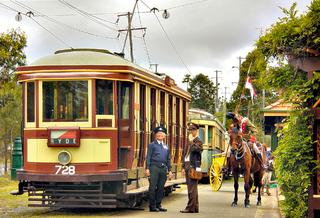
The Illawarra Light Railway Museum operates a mainline 2 ft narrow gauge light railway, a miniature 7+1⁄4 in gauge railway, and a museum located in Albion Park Rail, New South Wales, Australia.
Dunmore is a largely rural suburb of Shellharbour City in New South Wales, Australia. Dunmore is bisected north to south by the South Coast railway line and the Princes Highway.


