Belagavi District

Last updated

Belagavi District

Belgaum District
district
Gokak Falls.jpg
Gokak Falls in Belagavi district
Karnataka Belgaum locator map.svg
Location in Karnataka, India
Coordinates: 15°51′N74°33′E / 15.85°N 74.55°E / 15.85; 74.55 Coordinates: 15°51′N74°33′E / 15.85°N 74.55°E / 15.85; 74.55
CountryFlag of India.svg  India
Region North Karnataka
Division Belgaum division
HeadquartersBelgaum
Government
  Deputy CommissionerM G Hiremath
Area
[1]
  Total13,415 km2 (5,180 sq mi)
Population
 (2011) [1]
  Total4,779,661
  Density360/km2 (920/sq mi)
Languages
  OfficialKannada
Time zone UTC+5:30 (IST)
ISO 3166 code IN-KA
Vehicle registration
Sex ratio 1.04 /
Literacy64.2%
Precipitation 823 millimetres (32.4 in)
Website belagavi.nic.in

Belagavi District, [2] also known as Belgaum District, is a district in the state of Karnataka, India. The district is known as Sugar Bowl of Karnataka with 1.5 lakh (150,000) hectares being used for commercial production [3] and it has displaced Mandya district in sugar cane production over the last decade. [4] The city of Belgaum is the district headquarters in North Karnataka. It houses the second legislative building, where the Karnataka Legislature will meet once a year. A popular sweet is kunda. According to the 2011 Census of India, it has a population of 4,779,661, of which 24.03% live in urban areas, [5] making it the second most populous district in Karnataka (out of 30), after Bangalore. [6] The district has an area of 13,415 km2 (5,180 sq mi) making it the largest district in Karnataka, and is bounded on the west and north by the state of Maharashtra, on the northeast by Bijapur District, on the east by Bagalkot District, on the southeast by Gadag District, on the south by Dharwad District and Uttara Kannada districts, and on the southwest by the state of Goa.

Contents

History

Bhuvaraha Narasimha temple Halasi, Karnataka Halasi 12.jpg
Bhuvaraha Narasimha temple Halasi, Karnataka
Panchalingeshwara temple Hooli Panchalingeshwara temple.JPG
Panchalingeshwara temple Hooli

Belagavi is the Divisional Headquarters of North Karnataka. The original name of the town of Belgaum was Venugrama, meaning Bamboo Village. It is also known as Malnad Pradesh. The most ancient place in the district is Halsi; and this, according to inscriptions on copper plates discovered in its neighborhood, was once the capital of a dynasty of nine Kadamba kings. It appears that from the middle of the 6th century to about 760 the area was held by the Chalukyas, who were succeeded by the Rashtrakutas. After the break-up of the Rashtrakuta dynasty a portion of it survived in the Rattas (875–1250), who from 1210 onward made Venugrama their capital. Inscriptions give evidence of a long struggle between the Rattas and the Kadambas of Goa, who succeeded in the latter years of the 12th century in acquiring and holding part of the district. By 1208, however, the Kadambas had been overthrown by the Rattas, who in their turn succumbed to the Yadavas of Devagiri in 1250. After the overthrow of the Yadavas by the Delhi Sultanate (1320), Belgaum was for a short time under the rule of the latter; but only a few years later the part south of the Ghataprabha River was subject to the Hindu rajas of Vijayanagara. In 1347 the northern part was conquered by the Bahmani Sultanate, which in 1473 took the town of Belgaum and conquered the southern part also. When Aurangzeb overthrew the Bijapura sultans in 1686, Belgaum passed to the Mughals. In 1776 the country was overrun by Hyder Ali of Mysore, but was taken by the Madhavrao Peshwa with British assistance. In 1818 it was handed over to the British East India Company, and was made part of the district of Dharwar. In 1836 this was divided into two parts, the northern district becoming Belgaum. [7]

Yadur is situated beside the Krishna river, and there is a famous veerbhadra temple there. Many devotees visit the area from Karnataka and Maharashtra. Hooli is one of the oldest villages in Belgaum district. There are many Chalukya temples in the village, including the famous Panchaligeswara temple.

Kittur in Belgaum district is a place of historical importance. Rani Chennamma of Kittur (1778–1829) is known for her resistance to British rule.

The British had a sizable infantry post here, having realised the military importance of its geographic location. It is one of the reasons for Belgaum's sobriquet The Cradle of Infantry. Development of a rail network for the movement of resources and later troops was one of the means employed by both the British East India Company and the British to exert control over India. Belgaum's railway station, the Mahatma Gandhi Railway Station was established by the British. A signboard declaring the sobriquet can be seen hung on Platform 1 at the station.

Border dispute

After India became independent in 1947, the Belgavi district (which was in the erstwhile Bombay Presidency) became a part of the Bombay State. In 1948, the Belgaum Municipality that was dominated by Marathi speaking politicians requested the Indian Dominion, Indian Constituent Assembly, and the Boundary Commission to include the Belgaum Municipal District in the proposed Samyukta Maharashtra state for the Marathi speakers. [8]

In accordance with the established policy of bifurcation on a linguistic majority basis, in 1956, the Belgaum district was incorporated into the newly formed Mysore state (now Karnataka) with the passage of the States Reorganization Act, adjoining areas that had a majority of Marathi speaking citizens were included in the newly formed Maharashtra state. The Act, which reorganised India's states along linguistic and administrative lines, included Belgav in the Kannada-majority Karnataka, the district had most of the Marathi-speaking population hence the 'dispute'; [9] [10]

Administrative divisions

The administration of Belgaum District has been divided into 14 taluks. Athani taluk is the largest with an area of 1,997.70 km2 and Raybag taluk is the smallest with an area of 958.8 km2. The district comprises three revenue sub-divisions headquartered at Belgaum, Bailhongal and Chikodi which are headed by the Assistant commissioner and taluks headed by Tehsildar [11] and has six police sub-divisions. Apart from the Belgaum City Corporation, there are 17 municipalities, 20 towns, 485 gram panchayats, 1,138 inhabited villages and 26 non-inhabited villages. Belgaum is also the headquarters of the Belgaum Revenue Division.

Demographics

Historical population
YearPop.±% p.a.
19011,131,186    
19111,083,804−0.43%
19211,088,763+0.05%
19311,237,223+1.29%
19411,410,054+1.32%
19511,645,620+1.56%
19611,983,498+1.88%
19712,422,994+2.02%
19812,978,913+2.09%
19913,583,606+1.87%
20014,214,505+1.63%
20114,779,661+1.27%
source: [12]

According to the 2011 census Belgaum district has a population of 4,779,661, [6] roughly equal to the nation of Singapore [13] or the US state of Alabama. [14] This gives it a ranking of 25th in India (out of a total of 640). [6] The district has a population density of 356 inhabitants per square kilometre (920/sq mi). [6] Its population growth rate over the decade 2001–2011 was 13.38%. [6] There were 969 females for every 1000 males, [6] and a literacy rate of 73.94%. [6]

Education

Belgaum district is a home to three universities: Visvesvaraya Technological University, Rani Channamma University, Belagavi and KLE University. Also, it has a nine engineering colleges, two medical colleges, two dental colleges, 15 polytechnics, 7 Indian system of medical colleges, and 180 degree colleges. [15]

Industry

The district has seven industrial areas, one special economic zone (India's first precision engineering SEZ[ clarification needed ] with more than 200 acres) and 16 industrial estates. [3] The city's industrial growth begin when Babu Rao Pusalkar set up a small unit in city over a century ago and that transformed Belgaum city into foundry and hydraulics base. Now, the city has a large number of crankshaft, industrial castings and forging, machinery, hydraulics, and aluminium manufacturing units. [16]

Name of Industrial AreaExtent (acres)
Kanbargi Auto Complex267.00
Kakati74.75
Honaga209.5
Kangrali58.59
Gokak109.05
Kittur433.19
Kanagala848.00
Name of Industrial EstateExtent (acres)
Udyambag55.15
Udyambag Tq. Karigarika Sangh0.32
Angol- 121
Angol- 24.6
Kanbargi6
Khanapur9.57
Gokak9.62
Chikkodi6
Bailhongal3
Ramdurg9.4
Nippani3.5
Kangrali2.5
Desur41.34
Athani28
Borgaon75
Kagwad20

List of industrial clusters in Belgaum district that are identified by Ministry of Micro, Small and Medium Enterprises [17]

Cluster placeCluster activity
BelgaumFoundry, Powerloom and artisan activities like Dolls & Toys, Horn & Bone, Metalware, Artistic Chappals by hand
AngolWooden Furniture Cluster
UdyambagMachine Tool and Engineering Cluster
KudachiKudachi Jaggery Cluster
MadhabaviFoot Diamond Leather Cluster
RamdurgReadymade Garments Cluster, Birds Power loom Cluster
ChikkodiJaggery processing Cluster
KhanapurBricks Processing Cluster, Pottery & Clay, Terracotta, Textiles Hand Embroidered
AthaniAthani Raisins processing cluster
GokakDolls & Toys

Notable people

Publications

Related Research Articles

Belgaum City Corporation in Karnataka, India

Belgaum is a city in the Indian state of Karnataka located in its northern part along the Western Ghats. It is the administrative headquarters of the eponymous Belgaum division and Belgaum district. The Government of Karnataka has proposed making Belgaum the second capital of Karnataka, hence a second state administrative building Suvarna Vidhana Soudha was inaugurated on 11 October 2012.

Gokak City in Karnataka, India

Gokak is a taluka headquarters in the Belagavi district of Karnataka state, India. It is located around 70 km from Belagavi at the confluence of two rivers, the Ghataprabha and the Markandeya. The population of the city is according to 2011 census is approximately 150,773. Gokak city has second highest GDP in the district of Belagavi after Belagavi city. The common language is Kannada.

Bailhongal Taluk in Karnataka, India

Bailhongal is a Taluk in Belagavi District of Karnataka state in southern India. Bailhongal Taluk is located towards the north-east part of Belagavi. The taluk headquarters is about 44 km from the district headquarters. The total geographical area of the taluk is 1122.40 km2. There are 126 revenue villages and 14 hamlets with a total population of 356,400 people, according to the 2001 census.

Kittur Taluk in Karnataka, India

Kittur, also known as Kitturu and historically as Kittoor, is a taluka in the Belgaum district of the Indian state of Karnataka. It was part of Bailhongal taluka but was declared as an independent taluka on 23 October 2012 by the Chief Minister of Karnataka on the inauguration of Kittur Utsav. It is 177th Taluk of Karnataka State. It is a place of historical importance because of the armed rebellion of Kittur Chennamma (1778–1829), Rani of the State of Kittur against the British East India Company, during which a British Commissioner, St John Thackeray was killed.

Kittur Chennamma Indian freedom fighter

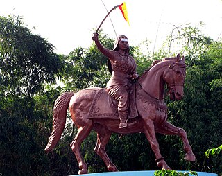
Kittur Chennamma was the Indian queen (rani) of Kittur, a princely state in present-day Karnataka. She led an armed rebellion against the British East India Company in 1824 in defiance of the doctrine of lapse in an attempt to maintain Indian control over the region, but was defeated and died imprisoned. One of the first female rulers to rebel against British rule, she has become a folk hero in Karnataka and symbol of the independence movement in India.

North Karnataka Place in Karnataka, India

North Karnataka is a geographical region in Deccan plateau from 300 to 730 metres elevation that constitutes the northern part of the Karnataka state in India. It is drained by the Krishna River and its tributaries the Bhima, Ghataprabha, Malaprabha, and Tungabhadra. North Karnataka lies within the Deccan thorn scrub forests ecoregion, which extends north into eastern Maharashtra. Most parts of the region has black fertile soil ideal for agriculture.

Hukeri Town in Karnataka, India

Hukkeri is a Town Municipal Council and taluka in Belagavi district in the Indian state of Karnataka. Archeological studies reveal that the name Hukkeri is supposed to have been derived from the word Huvinakeri which means Street of Flowers. During Adil Shahi times, roses of good quality were grown here and were sent to Bijapur.

Khanapur Town in Karnataka, India

Khanapur is a panchayat town in Belagavi, Belgaon district, Karnataka, India. It is about 26 km from Belagavi. The town is governed by the Khanapur Municipal Council. Khanapur is the headquarters for Khanapur Taluq. The town is on the Belgaum-Panaji National Highway, NH 4A. Khanapur is well connected by train and road to important cities in Karnataka, Goa, and Maharashtra. Kannada is the official language but Marathi is widely spoken in the town. 60% local population speaks Marathi as it shares its borders with Goa and Maharastra.

The Belgaum border dispute is a dispute involving the Indian states of Karnataka and Maharashtra. Belgaum is a part of Karnataka and was earlier part of the British India's Bombay Presidency. The Bombay Presidency encompassed present day Gujarat, Maharashtra as well as certain areas of Karnataka.

Athani, Belagavi City in Karnataka, Flag_of_Karnataka

Athani is a city in the Belagavi district of Karnataka, India. It is 140 kilometers from the city of Belagavi, 70 kilometers from Vijayapura, 55 kilometers from Miraj, 100 kilometers from Kolhapur, and 624 kilometers from Bengaluru.

Examba city in Karnataka, India

Examba is a City and Municipal Council in the Belgaum district of the Indian state of karnataka.

Madabhavi village in Karnataka, India

Madabhavi is a large village located in Athani taaluk of Belagavi district, Karnataka state of India. The village is famous for production leather chappals which have main market in Kolhapur. The village name came from Madya means central and Bhavi means open well. Open well is near panchayat of village.This village Has two Oldest Ancients Temples one Kalbhairava and another one is Madhukeshwar temple.

Raibag (Rural) town in Karnataka, India

Raibag (Rural) is a town in the southern state of Karnataka, India. It is located in the belagavi district of Karnataka.

Belgaum Fort

Belgaum Fort is in the city of Belgaum, in the Belgaum district, in Karnataka state, India. It was begun by Jaya Raya, also called Bichi Raja, an ally of the Ratta Dynasty, in the year 1204 AD. It has undergone several renovations over the centuries under dynastic rulers of the region.

Rani Chennamma Express

The Rani Chennamma Express is a daily train connecting the City of Bengaluru, Karnataka with city of Miraj, Sangli District of Maharashtra. This is one of the prestigious trains of the South Western Railway and generally gets the best coaches and locomotives that the infrastructure can support. This train operates daily and covers a distance of 749 km.This train ran up to Miraj Junction till 2002. Further extended up to Kolhapur in 2002 Railway Budget. Railway board confirms the origination & Termination of Rani chennama Exp again from Miraj as per Zero base time table.

Dodwad is a village in Belgaum district in the southern state of Karnataka, India.

Krishna Kittur Village makeme in Karnataka, India

Krishna-kittur is a village in the southern state of Karnataka, India. It is located in the Athani taluka of Belgaum district in Karnataka.

Sangolli is a village in Bailahongal taluk of Belgaum district Indian State of Karnataka, India.This is the birthplace of prominent warrior, Rayanna, from Karnataka, India. He was the army chief of the Kingdom of Kittur ruled at the time by Rani Chennamma and fought the British East India Company till his death. His life was the subject of the 2012 Kannada film Sangolli Rayanna.

Ratta dynasty was a minor Indian dynasty who ruled over the Belgaum region of modern Karnataka as a branch of Rashtrakutas. Savadatti (Saundatti), historically known as Sugandavarti was the capital of Ratta dynasty during 875-1250 CE period. Later their capital shifted to Belagavi (Belgaum) which is historically known as Venugrama. Belgaum was the capital of the Rattas during 1210 - 1250 AD. Rashtrika is a sanskritized form of Ratta. Hooli was also under the rule of Rattas of Saundatti.

Kadamba architecture

Kadamba architecture was a style of temple architecture founded by Mayurasharma in the 4th century AD in Karnataka, India. Kadambas created new style of architecture which was the basis of the Hoysalas style of architecture, developed original school of sculpture, was the forerunner of series of South Indian sculptors. Many temples at Aihole, Badami and Hampi are built in Kadamba style.

References

  1. 1 2 "2001 Census". Official Website of Belgaum District. Archived from the original on 21 July 2011. Retrieved 4 January 2011.
  2. "Belgaum becomes Belagavi, as Centre clears name change plan". The Indian Express. 18 October 2014. Retrieved 30 August 2020.
  3. 1 2 "Belagavi - foundry hub of North Karnataka" (PDF). karnataka.gov.in. Retrieved 14 March 2021.
  4. "Karnataka elections: Meet the five brothers from Belagavi who are contesting against each other". Hindustan Times. 4 May 2018. Retrieved 19 January 2020.
  5. "Archived copy". Archived from the original on 11 January 2010. Retrieved 27 August 2009.CS1 maint: archived copy as title (link)
  6. 1 2 3 4 5 6 7 "District Census 2011". Census2011.co.in. 2011. Retrieved 30 September 2011.
  7. Wikisource-logo.svg One or more of the preceding sentences incorporates text from a publication now in the public domain : Chisholm, Hugh, ed. (1911). "Belgaum". Encyclopædia Britannica . 3 (11th ed.). Cambridge University Press. p. 668.
  8. Ravi Sharma (3–16 December 2005). "A dispute revived". Frontline. Archived from the original on 16 October 2006. Retrieved 24 October 2006.
  9. "DomainMarket.com, The world's best brand new brands". Archived from the original on 12 May 2012.
  10. Jaishankar Jayaramiah (21 November 2005). "Karnataka caught in 'language' web". The Financial express. Archived from the original on 10 March 2007. Retrieved 1 November 2006.
  11. "Sub Divisions and Talukas | District Belagavi, Government of Karnataka | India" . Retrieved 18 January 2020.
  12. Decadal Variation In Population Since 1901
  13. US Directorate of Intelligence. "Country Comparison:Population" . Retrieved 1 October 2011. Singapore 4,740,737 July 2011 est.
  14. "2010 Resident Population Data". U. S. Census Bureau. Archived from the original on 19 October 2013. Retrieved 2011-09-30. Alabama 4,779,736
  15. "Belagavi District". www.investkarnataka.co.in. Retrieved 13 December 2019.
  16. URS, ANIL. "Belagavi: A city on the frontlines reinvents itself". @businessline. Retrieved 14 December 2019.
  17. "KARNATAKA STATE INDUSTRIAL PROFILE 2015-2016" (PDF). dcmsme.gov.in. Retrieved 13 December 2019.
  18. 1 2 "Gazetteer Department, Karnataka". gazetteer.kar.nic.in. Retrieved 22 November 2020.
  19. "Gazetteer Department, Karnataka". gazetteer.kar.nic.in. Retrieved 22 November 2020.