
Ellesmere Island is Canada's northernmost and third largest island, and the tenth largest in the world. It comprises an area of 196,236 km2 (75,767 sq mi), slightly smaller than Great Britain, and the total length of the island is 830 km (520 mi).

Victoria Island is a large island in the Arctic Archipelago that straddles the boundary between Nunavut and the Northwest Territories of Canada. It is the eighth-largest island in the world, and at 217,291 km2 (83,897 sq mi) in area, it is Canada's second-largest island. It is nearly double the size of Newfoundland (111,390 km2 [43,010 sq mi]), and is slightly larger than the island of Great Britain (209,331 km2 [80,823 sq mi]) but smaller than Honshu (225,800 km2 [87,200 sq mi]). The western third of the island lies in the Inuvik Region of the Northwest Territories; the remainder is part of Nunavut's Kitikmeot Region. The population of 2,168 is divided among 2 settlements, the larger of which is in Nunavut and the other of which is in the Northwest Territories.
Quttinirpaaq National Park is located on the northeastern corner of Ellesmere Island in the Qikiqtaaluk Region of Nunavut, Canada. It is the second most northerly park on Earth after Northeast Greenland National Park. In Inuktitut, Quttinirpaaq means "top of the world". It was established as Ellesmere Island National Park Reserve in 1988, and the name was changed to Quttinirpaaq in 1999, when Nunavut was created, and became a national park in 2000. The reserve covers 37,775 km2 (14,585 sq mi), making it the second largest park in Canada, after Wood Buffalo National Park.
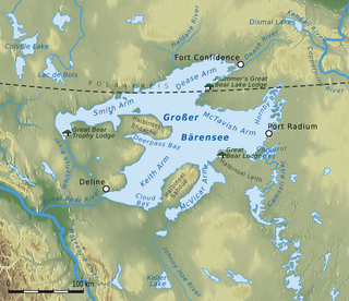
Great Bear Lake is a lake in the boreal forest of Canada. It is the largest lake entirely in Canada, the fourth-largest in North America, and the eighth-largest in the world. The lake is in the Northwest Territories, on the Arctic Circle between 65 and 67 degrees of northern latitude and between 118 and 123 degrees western longitude, 156 m (512 ft) above sea level.

Alert, in the Qikiqtaaluk Region of Nunavut, Canada, is the northernmost continuously inhabited place in the world, on Ellesmere Island at latitude 82°30'05" north, 817 kilometres (508 mi) from the North Pole. It takes its name from HMS Alert, which wintered 10 km (6.2 mi) east of the present station, off what is now Cape Sheridan, in 1875–1876.

The Spanish River is a river in Algoma District, Sudbury District and Greater Sudbury in Northeastern Ontario, Canada. It flows 338 kilometres (210 mi) in a southerly direction from its headwaters at Spanish Lake and Duke Lake to its mouth at the North Channel of Lake Huron just outside the community of Spanish.

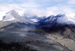
Tanquary Fiord Airport is located at the southern side of Tanquary Fiord, Nunavut, Canada, close to the end of the fiord. It is located within Quttinirpaaq National Park and is maintained by Parks Canada. It serves as the main access to the park for tourists. Hikers to Lake Hazen, which is located 70 km (43 mi) to the northeast, start from Tanquary Camp.

Unorganized North Algoma District is an unorganized area in northeastern Ontario, Canada, comprising all areas in Algoma District, north of the Sault Ste. Marie to Elliot Lake corridor, which are not part of an incorporated municipality or a First Nation. It covers 44,077.03 km2 (17,018.24 sq mi) of land, and had a population of 6050 in 2021. Many of these communities were/are stations on the Algoma Central Railway or were logging/mining towns.
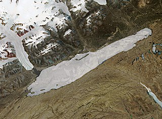
Lake Hazen is a freshwater lake in the northern part of Ellesmere Island, Nunavut, Canada, north of the Arctic Circle. It is the largest lake north of the Arctic Circle by volume. By surface area it is third largest, after Lake Taymyr in Russia and Lake Inari in Finland.
Mount Ayles is a mountain located on Ellesmere Island, Nunavut, Canada. It forms part of the border of the Quttinirpaaq National Park. Like the nearby Ayles Ice Shelf, the mountain was named by the Geological Survey of Canada in 1965 for Adam Ayles, a petty officer on-board HMS Alert, who was serving in the British Arctic Expedition under George Nares.

The Mount Meager massif is a group of volcanic peaks in the Pacific Ranges of the Coast Mountains in southwestern British Columbia, Canada. Part of the Cascade Volcanic Arc of western North America, it is located 150 km (93 mi) north of Vancouver at the northern end of the Pemberton Valley and reaches a maximum elevation of 2,680 m (8,790 ft). The massif is capped by several eroded volcanic edifices, including lava domes, volcanic plugs and overlapping piles of lava flows; these form at least six major summits including Mount Meager which is the second highest of the massif.
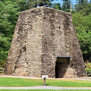
Pine Grove Furnace State Park is a protected Pennsylvania area that includes Laurel and Fuller Lakes in Cooke Township of Cumberland County. The Park accommodates various outdoor recreation activities, protects the remains of the Pine Grove Iron Works (1764), and was the site of Laurel Forge (1830), Pine Grove Park (1880s), and a brick plant (1892). The Park is 8 miles (13 km) from exit 37 of Interstate 81 on Pennsylvania Route 233.
Qikiqtaaluk, Unorganized in Nunavut, Canada, is part of a larger census division known as the Qikiqtaaluk Region. This area covers the whole Qikiqtaaluk Region outside the 13 communities such as Iqaluit, Resolute or Grise Fiord. Baffin has a rocky mountainous landscape. Prior to the 2021 Canadian census it was known as Baffin.
Hazen's Notch is a mountain pass in Westfield, in the northern Green Mountains of Vermont. Hazen's Notch was named after Moses Hazen, who in 1779 led the construction of the Bayley Hazen Military Road. The road was planned to extend from Newbury, Vermont, to Saint-Jean-sur-Richelieu, Quebec, not far from Montreal, to facilitate an invasion of Canada during the American Revolutionary War; it had reached this point when construction stopped.
Commonwealth Mountain is a mountain on Ellesmere Island, Nunavut, Canada. It lies in western Quttinirpaaq National Park, which is the most northerly extent of Canada, and is the second most northerly park on Earth after Northeast Greenland National Park.

Ward Hunt Island is a small, uninhabited island in the Arctic Ocean, located off the north coast of Ellesmere Island near the Ward Hunt Ice Shelf. The island is located just 750 km (470 mi) from the geographical North Pole. The northern cape of Ward Hunt Island is one of the northernmost elements of land in Canada. Only a 17 km (11 mi) stretch of northern coast of Ellesmere Island around Cape Columbia is more northerly. The island is 5.0 km (3.1 mi) long, east to west, and 3.0 km (1.9 mi) wide. The first known sighting was in 1876 by Pelham Aldrich, a lieutenant with the George Nares expedition, and named for George Ward Hunt, who was First Lord of the Admiralty at the time (1874–1877). Today, the Island is part of the Quttinirpaaq National Park.

Sauble Falls Provincial Park is located in the town of South Bruce Peninsula, Bruce County in southwestern Ontario, Canada, 36 kilometres (22 mi) west of Owen Sound. It is in the lower drainage basin of the Sauble River, which flows into Lake Huron. The campground consists of two sections divided by County Road 13. The west section of the site is a quiet zone. Group camping is available in the east section. Many sites along the east portion of the park back up against the Sauble River. The park is also the downstream terminus of the Rankin River canoe route.

The Volcano, also known as Lava Fork volcano, is a small cinder cone in the Boundary Ranges of the Coast Mountains in northwestern British Columbia, Canada. It is located approximately 60 km (40 mi) northwest of the small community of Stewart near the head of Lava Fork. With a summit elevation of 1,656 m (5,433 ft) and a topographic prominence of 311 m (1,020 ft), it rises above the surrounding rugged landscape on a remote mountain ridge that represents the northern flank of a glaciated U-shaped valley.

Tanquary Fiord is a fjord on the north coast of the Arctic Archipelago's Ellesmere Island, Nunavut, Canada. It is located in the Quttinirpaaq National Park and extends 48 km (30 mi) in a north-westerly direction from Greely Fiord.
McGill Arctic Research Station (Expedition Fiord) (MARS) is a small research station operated by McGill University located near the centre of Axel Heiberg Island, Nunavut. It is located approximately 115 km (71 mi) southwest of Eureka, a weather and research station. It was first established in 1959 after scientists explored South Fiord (Expedition Fiord). The station contains a small hut, a cook house and two temporary structures. It can support 8-12 people and gives them access to the research activities. The current activities are glaciology, climate change, permafrost, hydrology, geology, geomorphology, limnology, planetary analogues, and microbiology. Today, the station is only used in the summer months so there would be enough power generated from the solar panels.

