Hurt, Virginia | |
---|---|
Coordinates: 37°5′42″N79°17′54″W / 37.09500°N 79.29833°W | |
Country | United States |
State | Virginia |
County | Pittsylvania |
Government | |
• Type | Council-Manager |
• Mayor | Gary Hodnett |
• Town Council | Bob Majure Gary Poindexter Paul Johnson Michael Blackstock Kathy Keesee Steve Worley |
Area | |
• Total | 3.51 sq mi (9.10 km2) |
• Land | 3.48 sq mi (9.00 km2) |
• Water | 0.04 sq mi (0.09 km2) |
Elevation | 748 ft (228 m) |
Population (2010) | |
• Total | 1,267 |
• Estimate (2020) [2] | 1,267 |
• Density | 364.08/sq mi (141/km2) |
Time zone | UTC-5 (Eastern (EST)) |
• Summer (DST) | UTC-4 (EDT) |
ZIP code | 24563 |
Area code | 434 |
FIPS code | 51-39224 [3] |
GNIS feature ID | 1468433 [4] |
Website | www |
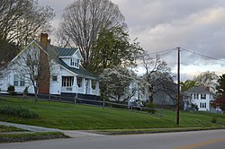
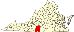
Hurt is a town in Pittsylvania County, Virginia, United States. Population was 1,269 at the 2020 census. It is included in the Danville, Virginia Metropolitan Statistical Area.
The community bears the name of Colonel John R. Hurt, an early citizen. [5]
Hill Grove School and Locust Hill are listed on the National Register of Historic Places. [6]
According to the United States Census Bureau, the town has a total area of 3.41 square miles (9 km2).
The sole major road to go through the town is U.S. Route 29, via a business spur that also goes through Altavista; the main road bypasses both towns to the west.
Census | Pop. | Note | %± |
---|---|---|---|
1970 | 1,434 | — | |
1980 | 1,481 | 3.3% | |
1990 | 1,294 | −12.6% | |
2000 | 1,276 | −1.4% | |
2010 | 1,304 | 2.2% | |
2020 | 1,267 | −2.8% | |
U.S. Decennial Census [7] |
2000 As of the census [3] of 2000, there were 1,276 people, 541 households, and 385 families living in the town. The population density was 487.2 people per square mile (188.0/km2). There were 592 housing units at an average density of 226.0 per square mile (87.2/km2). The racial makeup of the town was 86.52% White, 12.07% African American, 0.16% Native American, 0.39% Asian, 0.31% from other races, and 0.55% from two or more races. Hispanic or Latino of any race were 0.94% of the population.
There were 541 households, out of which 29.2% had children under the age of 18 living with them, 56.4% were married couples living together, 11.8% had a female householder with no husband present, and 28.7% were non-families. 24.8% of all households were made up of individuals, and 11.6% had someone living alone who was 65 years of age or older. The average household size was 2.36 and the average family size was 2.80.
In the town, the population was spread out, with 21.7% under the age of 18, 6.9% from 18 to 24, 28.4% from 25 to 44, 25.3% from 45 to 64, and 17.7% who were 65 years of age or older. The median age was 41 years. For every 100 females there were 87.6 males. For every 100 females aged 18 and over, there were 86.7 males.
The median income for a household in the town was $36,467, and the median income for a family was $40,938. Males had a median income of $29,219 versus $21,675 for females. The per capita income for the town was $16,875. About 9.3% of families and 10.7% of the population were below the poverty line, including 17.6% of those under age 18 and 13.0% of those age 65 or over.
Stamps is a city in Lafayette County, Arkansas, United States. The population was 1,693 at the 2010 census, down from 2,131 at the 2000 census.
Onward is a town in Tipton Township, Cass County, Indiana, United States. The population was 100 at the 2010 census.
Diagonal is a city in northwest Ringgold County, Iowa, the United States. The population was 344 at the time of the 2020 census.
Rake is a town in Winnebago County, Iowa, United States. The population was 186 at the time of the 2020 census. Its ZIP code is 50465.
Stamping Ground is a home rule-class city in Scott County, Kentucky, United States. The population was 643 at the 2010 census. It is part of the Lexington–Fayette Metropolitan Statistical Area.
Secretary is a town in Dorchester County, Maryland, United States. The population was 535 at the 2010 census.
Dent is a city in Otter Tail County, Minnesota, United States. The population was 173 at the 2020 census.
Moyer Township is a township in Swift County, Minnesota, United States. The population was 125 at the 2000 census.
Pace is a town in Bolivar County, Mississippi, United States. Per the 2020 census, the population was 183.
Lima is a town in Beaverhead County, Montana, United States. As of the 2020 census, the population was 212.
St. Louisville or Saint Louisville is a village in Licking County, Ohio, United States, along the North Fork of the Licking River. The population was 352 at the 2020 census.
Smithville is a village in Wayne County, Ohio, United States. The population was 1,338 at the time of the 2020 census. The village derives its name from Thomas Smith, a pioneer settler.
Tea is a city in Lincoln County, South Dakota, United States and is a suburb of Sioux Falls. The population was 5,598 at the 2020 census, and was estimated to be 6,918 in 2022.
Cedar Grove is a town in Kanawha County, West Virginia, United States. The population was 714 at the 2020 census. Cedar Grove was incorporated in 1902. Its name is derived from the time the town was established, when a large juniper forest, misidentified as cedars by early settlers, was growing at that location. Cedar Grove is the site of Fort Kelley and the oldest settlement in the Kanawha Valley, dating from 1773. Landmarks located here include the Tompkins Home (1844) and the Old Brick Church (1853). The current mayor is as of July 1, 2023, is Melissa (Missy) Young.
Cowen is a town in Webster County, West Virginia, United States. The population was 488 at the 2020 census.
Hundred is a town in Wetzel County, West Virginia, United States. The population was 257 at the 2020 census. It was named for the fact that local resident Henry "Old Hundred" Church was a centenarian. Hundred is the only place in the United States with this name.
Fence is a town in Florence County, Wisconsin, United States. The population was 231 at the 2000 census. The origin of the name "Fence" is obscure.
Farmington is a town in Jefferson County, Wisconsin, United States. The population as of the 2010 census was 1,380.
Green Valley is a town in Marathon County, Wisconsin, United States. It is part of the Wausau, Wisconsin Metropolitan Statistical Area. The population was 541 at the 2010 census. The unincorporated community of Rangeline is located partially in the town.
Bloomington is a village in Grant County, Wisconsin, United States. The population was 735 as of the 2010 census. The village is located within the Town of Bloomington.