Judge John Sutter Regional Shoreline

Last updated
Judge John Sutter Regional Shoreline
Judge John Sutter Regional Shoreline Observation Pier.jpg
Observation Pier seen from Bay Bridge
Judge John Sutter Regional Shoreline
TypeRegional Shoreline
LocationAlameda County, California, United States
Nearest cityOakland, California
Coordinates 37°49′19″N122°19′12″W / 37.82194°N 122.32000°W / 37.82194; -122.32000
Area22.47 acres (0.0909 km2)
Created2020
Operated by East Bay Regional Park District
StatusOpen

Judge John Sutter Regional Shoreline is a park located in Oakland, California along the shore of San Francisco Bay at the foot of the San Francisco-Oakland Bay Bridge. It is part of the East Bay Regional Parks District. The park opened on October 21, 2020. [1]

Contents

History

From 1903 to the early 1940s, the site of the park was the east end of the Key System mole, a long causeway and pier which once extended nearly to Yerba Buena Island. Key System trains ran the length of the mole to the ferry slips where transbay commuters transferred between trains and ferryboats. During the construction of the Bay Bridge in the 1930s, the site was transformed for the planned bridge railway on the lower deck of the Bay Bridge, to be used by the Southern Pacific, Sacramento Northern and the Key System. Service over the bridge railway commenced in January 1939. A substation located at the site provided electrical power to all the Key System trains. The 1930s-era industrial Bridge Yard building was a maintenance center for the electric trains.

In 1941, the Department of the Army established the Oakland Army Base at the site as a transportation port and distribution terminal. For 60 years, it served as an entry and return point for supplies, equipment, and soldiers that served in World War II, the Korean War, the Vietnam War, Operation Desert Shield, and Operation Desert Storm. The base closed in 1999.

The idea of the park was thought up by former Park District Board Member John Sutter, who first proposed the concept of a waterfront park at the then current Oakland Army Base in a 1967 letter to the Association of Bay Area Governments. The park is the culmination of decades of cooperation between a nine member consortium of local, regional, and state agencies, which includes the City of Oakland, the Association of Bay Area Governments, the East Bay Regional Park District, and the California Department of Transportation. [2]

The park is named after Judge John Sutter, an East Bay civic and environmental leader who led a long career as a superior court judge, as Oakland's vice mayor, and as former East Bay Regional Park District Director. He was the president and a founding member of Citizens for Regional Recreation and Parks and was instrumental in obtaining and preserving public access to the bay shoreline. [3]

Park features

The park features the newly renovated Bridge Yard building, which serves as a hub for activity and as a venue for public events and conferences. The 24,000 square foot, 1930s era building is due to serve as a space for recreational programming and event space. [3]

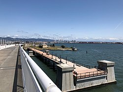
Made from the existing foundations of the old Bay Bridge, the park has a 600-foot long observation pier with views of the bay and the bridge. The pier also provides public waterfront access for fishing. [4]

With the opening of the park, improved parking and pedestrian access has made it easier to access the Alexander Zuckermann Bay Bridge Trail. [5] Open to both cyclists and pedestrians, the trail, which opened in 2016, is part of the San Francisco Bay Trail and extends across the Bay Bridge to both Yerba Buena and Treasure Island. [6]

Related Research Articles

<span class="mw-page-title-main">San Francisco Bay</span> Shallow estuary on the coast of California, United States

San Francisco Bay is a large tidal estuary in the U.S. state of California, and gives its name to the San Francisco Bay Area. It is dominated by the cities of San Francisco, San Jose, and Oakland.

<span class="mw-page-title-main">Emeryville, California</span> City in California, United States

Emeryville is a city located in northwest Alameda County, California, in the United States. It lies in a corridor between the cities of Berkeley and Oakland, with a border on the shore of San Francisco Bay. The resident population was 12,905 as of 2020. Its proximity to San Francisco, the Bay Bridge, the University of California, Berkeley, and Silicon Valley has been a catalyst for recent economic growth.

<span class="mw-page-title-main">Yerba Buena Island</span> Neighborhood of San Francisco, California, US

Yerba Buena Island sits in San Francisco Bay within the borders of the City and County of San Francisco. The Yerba Buena Tunnel runs through its center and connects the western and eastern spans of the San Francisco–Oakland Bay Bridge, linking the city with Oakland, California. Treasure Island is connected by a causeway to Yerba Buena Island. According to the United States Census Bureau, Yerba Buena Island and Treasure Island together have a land area of 0.901 square miles (2.33 km2) with a total population of 2,500 as of the 2010 census.

<span class="mw-page-title-main">San Francisco–Oakland Bay Bridge</span> Complex of bridges spanning San Francisco Bay

The San Francisco–Oakland Bay Bridge, known locally as the Bay Bridge, is a complex of bridges spanning San Francisco Bay in California. As part of Interstate 80 and the direct road between San Francisco and Oakland, it carries about 260,000 vehicles a day on its two decks. It includes one of the longest bridge spans in the United States.

<span class="mw-page-title-main">Point Pinole Regional Shoreline</span> Regional park in San Pablo Bay, California

Point Pinole Regional Shoreline is a regional park on the shores of the San Pablo Bay, California, in the United States. It is approximately 2,315 acres (9.37 km2) in area, and is operated by the East Bay Regional Park District. It includes the Dotson Family Marsh and the Point Pinole Lagoon and hosts the North Richmond Shoreline Festival.

<span class="mw-page-title-main">Key System</span> Former local electric railway service in the East Bay

The Key System was a privately owned company that provided mass transit in the cities of Oakland, Berkeley, Alameda, Emeryville, Piedmont, San Leandro, Richmond, Albany, and El Cerrito in the eastern San Francisco Bay Area from 1903 until 1960, when it was sold to a newly formed public agency, AC Transit. The Key System consisted of local streetcar and bus lines in the East Bay, and commuter rail and bus lines connecting the East Bay to San Francisco by a ferry pier on San Francisco Bay, later via the lower deck of the Bay Bridge. At its height during the 1940s, the Key System had over 66 miles (106 km) of track. The local streetcars were discontinued in 1948 and the commuter trains to San Francisco were discontinued in 1958. The Key System's territory is today served by BART and AC Transit bus service.

<span class="mw-page-title-main">Embarcadero (San Francisco)</span> Waterfront and roadway along San Francisco Bay

The Embarcadero is the eastern waterfront of Port of San Francisco and a major roadway in San Francisco, California. It was constructed on reclaimed land along a three mile long engineered seawall, from which piers extend into the bay. It derives its name from the Spanish verb embarcar, meaning "to embark"; embarcadero itself means "the place to embark." The Central Embarcadero Piers Historic District was added to the National Register of Historic Places on November 20, 2002.

<span class="mw-page-title-main">Eastern span replacement of the San Francisco–Oakland Bay Bridge</span> Seismic stabilization megaproject in California (2002–2013)

The eastern span replacement of the San Francisco–Oakland Bay Bridge was a construction project to replace a seismically unsound portion of the Bay Bridge with a new self-anchored suspension bridge (SAS) and a pair of viaducts. The bridge is in the U.S. state of California and crosses the San Francisco Bay between Yerba Buena Island and Oakland. The span replacement took place between 2002 and 2013, and is the most expensive public works project in California history, with a final price tag of $6.5 billion, a 2,500% increase from the original estimate of $250 million, which was an initial estimate for a seismic retrofit of the span, not the full span replacement ultimately completed. Originally scheduled to open in 2007, several problems delayed the opening until September 2, 2013. With a width of 258.33 ft (78.74 m), comprising 10 general-purpose lanes, it is the world's widest bridge according to Guinness World Records.

<span class="mw-page-title-main">Port of San Francisco</span> Organization that oversees port facilities in San Francisco, California, United States

The Port of San Francisco is a semi-independent organization that oversees the port facilities at San Francisco, California, United States. It is run by a five-member commission, appointed by the Mayor and approved by the Board of Supervisors. The Port is responsible for managing the larger waterfront area that extends from the anchorage of the Golden Gate Bridge, along the Marina district, all the way around the north and east shores of the city of San Francisco including Fisherman's Wharf and the Embarcadero, and southward to the city line just beyond Candlestick Point. In 1968, the State of California, via the California State Lands Commission for the State-operated San Francisco Port Authority, transferred its responsibilities for the Harbor of San Francisco waterfront to the City and County of San Francisco / San Francisco Harbor Commission through the Burton Act AB2649. All eligible State port authority employees had the option to become employees of the City and County of San Francisco to maintain consistent operation of the Port of San Francisco.

<span class="mw-page-title-main">East Bay Electric Lines</span> Former railway lines in the San Francisco Bay Area

The East Bay Electric Lines were a unit of the Southern Pacific Railroad that operated electric interurban-type trains in the East Bay region of the San Francisco Bay Area. Beginning in 1862, the SP and its predecessors operated local steam-drawn ferry-train passenger service in the East Bay on an expanding system of lines, but in 1902 the Key System started a competing system of electric lines and ferries. The SP then drew up plans to expand and electrify its system of lines and this new service began in 1911. The trains served the cities of Berkeley, Albany, Emeryville, Oakland, Alameda, and San Leandro transporting commuters to and from the large Oakland Pier and SP Alameda Pier. A fleet of ferry boats ran between these piers and the docks of the Ferry Building on the San Francisco Embarcadero.

<span class="mw-page-title-main">Berkeley Marina</span> Neighborhood of Berkeley in Alameda, California, United States

The Berkeley Marina is the westernmost portion of the city of Berkeley, California, located west of the Eastshore Freeway at the foot of University Avenue on San Francisco Bay. Narrowly speaking, "Berkeley Marina" refers only to the city marina, but in common usage, it applies more generally to the surrounding area.

<span class="mw-page-title-main">India Basin, San Francisco</span> Place

India Basin is neighborhood, named after the body of water, in the southeastern part of San Francisco, California, considered to be part of the larger Bayview–Hunters Point neighborhood.

<span class="mw-page-title-main">Oakland Long Wharf</span> Former rail-ferry pier in California

The Oakland Long Wharf was an 11,000-foot railroad wharf and ferry pier along the east shore of San Francisco Bay located at the foot of Seventh Street in West Oakland. The Oakland Long Wharf was built, beginning 1868, by the Central Pacific Railroad on what was previously Oakland Point. Beginning November 8, 1869, it served as the west coast terminus of the First transcontinental railroad. In the 1880s, Southern Pacific Railroad took over the CPRR, extending it and creating a new ferry terminal building with the official station name Oakland Pier. The entire structure became commonly and popularly called the Oakland Mole. Portions of the Wharf lasted until the 1960s. The site is now part of the facilities of the Port of Oakland, while passenger train service operates at the nearby Jack London Square/Dellums Station and another nearby station in Emeryville.

<span class="mw-page-title-main">Golden Gate International Exposition</span> Worlds Fair 1939-1940 at San Franciscos Treasure Island

The Golden Gate International Exposition (GGIE) (1939 and 1940), held at San Francisco's Treasure Island, was a World's Fair celebrating, among other things, the city's two newly built bridges. The San Francisco–Oakland Bay Bridge opened in 1936 and the Golden Gate Bridge in 1937. The exposition opened from February 18, 1939, through October 29, 1939, and from May 25, 1940, through September 29, 1940; it drew 17 million visitors to Treasure Island.

<span class="mw-page-title-main">Ferries of San Francisco Bay</span>

San Francisco Bay in California has been served by ferries of all types for over 150 years. John Reed established a sailboat ferry service in 1826. Although the construction of the Golden Gate Bridge and the San Francisco–Oakland Bay Bridge led to the decline in the importance of most ferries, some are still in use today for both commuters and tourists.

<span class="mw-page-title-main">Miller/Knox Regional Shoreline</span> Bayside park

Miller/Knox Regional Shoreline is a 295-acre (1.19 km2) bayside park near the Brickyard Cove neighborhood of the Point Richmond District in Richmond, California.

<span class="mw-page-title-main">Middle Harbor Shoreline Park</span>

Middle Harbor Shoreline Park (MHSP) is located on San Francisco Bay and the Port of Oakland entrance channel, west of downtown Oakland, California. It is owned and operated by the Port of Oakland. The park entrance is at the intersection of 7th Street and Middle Harbor Road. It is open seven days a week from 8 a.m. to dusk.

<span class="mw-page-title-main">Oakland Army Base</span> Decommissioned US Army base in California

The Oakland Army Base, also known as the Oakland Army Terminal, is a decommissioned United States Army base in the San Francisco Bay Area of California. The base was located at the Port of Oakland on Maritime Street just south of the eastern entrance to the San Francisco–Oakland Bay Bridge.

<span class="mw-page-title-main">Yerba Buena Tunnel</span> Highway tunnel in San Francisco, California

The Yerba Buena Tunnel, also known as the Yerba Buena Island Tunnel, is a highway tunnel in San Francisco, California. It is the part of San Francisco–Oakland Bay Bridge complex that crosses Yerba Buena Island. The Yerba Buena Tunnel carries ten lanes of Interstate 80 (I-80) on two decks, connecting the two component spans of the Bay Bridge, the western suspension span and the eastern self-anchored suspension span. At the opening of the Bay Bridge in 1936, it was the world's largest-bore tunnel.

<span class="mw-page-title-main">Ferry Point, California</span>

Ferry Point is a cape on the San Francisco Bay in western Richmond, California, United States. Once the Northern California terminal for the Atchison, Topeka and Santa Fe Railway, the area has been developed as a regional park.

References

  1. San Jose Mercury News, October 21, 2020
  2. "New Shoreline Park Opening at East Touchdown of Bay Bridge". Martinez Tribune. 2020-10-21. Retrieved 2020-10-30.
  3. 1 2 "Oakland's new Sutter Regional Shoreline park now open". East Bay Times. 2020-10-18. Retrieved 2020-10-29.
  4. Rubenstein, Steve (2020-10-25). "New East Bay shoreline park and pier opens with accessible fishing and unusual views". www.sfchronicle.com. Retrieved 2021-04-13.
  5. "New regional park officially opens next to Bay Bridge toll plaza". The San Francisco Examiner. 2020-10-22. Retrieved 2021-04-13.
  6. "VIDEO: Bay Bridge bike path opens to Yerba Buena Island". KRON4. 2016-10-21. Retrieved 2021-04-13.