The following highways are numbered 802:
| Preceded by 801 | Lists of highways 802 | Succeeded by 803 |
Wi-Fi is a family of wireless network protocols based on the IEEE 802.11 family of standards, which are commonly used for local area networking of devices and Internet access, allowing nearby digital devices to exchange data by radio waves. These are the most widely used computer networks, used globally in home and small office networks to link devices and to provide Internet access with wireless routers and wireless access points in public places such as coffee shops, hotels, libraries, and airports to provide visitors.

U.S. Route 21 or U.S. Highway 21 (US 21) is a major north–south United States Numbered Highway in the Southeastern United States that extends 394 miles (634 km). The southern terminus is in Hunting Island State Park, South Carolina, 14.4 miles (23.2 km) south of the junction with US 21 Business and South Carolina Highway 802 (SC 802) in Beaufort. The northern terminus is in Wytheville, Virginia, at an interchange with Interstate 81 (I-81) and US 52. Despite the "1" indicating that it is a major north–south highway, US 21 only travels through three states and is no longer a cross-country route as it has been replaced with I-77 in both Ohio and West Virginia. It also has the second-shortest length of all of the major north–south routes, just behind US 91. The route travels through the states of South Carolina, North Carolina, and Virginia. It also connects through major Southeastern cities such as Columbia, South Carolina, and Charlotte, North Carolina. The northern portion of the road travels parallel to I-77 in northern South Carolina and North Carolina. The road also has three interchanges with I-26 in Lexington and Calhoun counties in South Carolina.
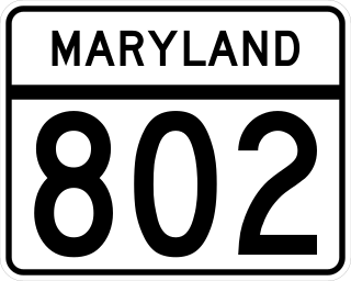
Maryland Route 802 is a state highway in the U.S. state of Maryland. Known as Batts Neck Road, the state highway runs 1.02 miles (1.64 km) as a north–south highway between junctions with MD 8 in Normans on Kent Island. MD 802 is the old alignment of MD 8 through Normans. The state highway was assigned after MD 8 was relocated by the early 1970s.
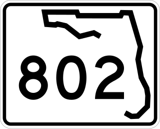
State Road 802 (SR 802) is a major east–west highway serving central Palm Beach County, Florida spanning 10.313 miles (16.597 km). The western terminus of SR 802 is an intersection with U.S. Route 441 (US 441) and SR 7 near Wellington; the eastern terminus is an intersection with Ocean Boulevard (SR A1A) in Lake Worth Beach. State Road 802 is a major commuter highway that is also a primary access road for the beaches of Palm Beach County. The majority of SR 802 is known locally as Lake Worth Road.

Route 123 is a secondary state highway in southwestern Connecticut from Norwalk to the New York state line near the town of Lewisboro.

Tertiary Highway 802, commonly referred to as Highway 802, is a provincially maintained tertiary road in the Canadian province of Ontario, located in Thunder Bay District. The 13.7-kilometre (8.5 mi) route branches both north and south from Highway 11 to connect with the community of Kashabowie and the ghost town of Burchell Lake, respectively. The highway was established in 1962 at the peak of operations of the Burchell Lake mine. Although the mine and town were subsequently abandoned in 1966, the highway remains under provincial jurisdiction. The section that travels concurrently with Highway 11 forms part of the Trans-Canada Highway.
11B may refer to :
11A may refer to:

South Carolina Highway 802 (SC 802), is a 6.690-mile (10.767 km) state highway located entirely within Beaufort County, South Carolina. Also known locally as Sams Point Road, SC 802 serves as the principal arterial for Lady's Island and provides the only access to Coosaw Island.
King's Highway 109, or Highway 109, is a former provincial highway in Ontario. It was used on two separate, unrelated routes during the 1950s and 1960s:
IEEE 802.11ac-2013 or 802.11ac is a wireless networking standard in the IEEE 802.11 set of protocols, providing high-throughput wireless local area networks (WLANs) on the 5 GHz band. The standard has been retroactively labelled as Wi-Fi 5 by Wi-Fi Alliance.

North Carolina Highway 145 is a primary state highway in the U.S. state of North Carolina. It runs from the South Carolina state line to U.S. Route 74 entirely in Anson County.
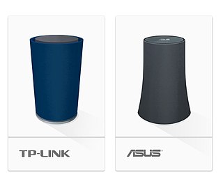
Google OnHub was a residential wireless router product from Google, Inc. The two variants are manufactured by TP-Link and ASUS. Google's official tagline for the product is "We’re streaming and sharing in new ways our old routers were never built to handle. Meet OnHub, a router from Google that is built for all the ways you use Wi-Fi." In 2016, Google released the Google Wifi router with mesh networking, and combined its functionality and network administration with the OnHub so that OnHub and Google Wifi may both be used interchangeably in mesh networks.
Secondary Highway 514, commonly referred to as Highway 514, was a secondary highway in the Canadian province of Ontario. It was used on two separate routes from the 1950s to the 1990s: