The following highways are numbered 955:
| Preceded by 954 | Lists of highways 955 | Succeeded by 956 |
Razi or al-Razi is a name that was historically used to indicate a person coming from Ray, Iran.

Highway to Hell is the sixth studio album by Australian hard rock band AC/DC, released on 27 July 1979. It is the first of three albums produced by Robert John "Mutt" Lange, and is the last album featuring lead singer Bon Scott, who died on 19 February 1980.
Route 16 is a two-lane highway in the Canadian province of New Brunswick. The 52 km (32 mi) route begins at Route 2 in Tantramar and ends at the midpoint of the Confederation Bridge, where it becomes Prince Edward Island Route 1.

The Ziwiye hoard is a treasure hoard containing gold, silver, and ivory objects, also including a few gold pieces with the shape of human face, that was uncovered on in Ziwiyeh plat near Saqqez city in Kurdistan Province, Iran, in 1947.
Autoroute 955 is a short 14.7-kilometre (9.1 mi) two-lane highway which links Autoroute 20 in Sainte-Eulalie with Saint-Albert.

Highway 955, also known as Semchuk Trail, is a provincial highway in the Canadian province of Saskatchewan. It runs from Highway 155 near La Loche to Cluff Lake mine. The mine has been closed since the early 2000s and its adjacent airstrip is also closed now, meaning there are no formal services at the northern turn-around point. Drivers using the route need to carry extra fuel and other supplies, including spare tires owing to the sharp gravel used on the road. The name "Semchuk Trail" comes from Martin Semchuk who, along with John F. Midgett, and Jonas Clarke, were involved in building the original trail in 1955–56.
Highway 155 is a paved, undivided provincial highway in the Canadian province of Saskatchewan. It runs from Highway 55 near Green Lake until La Loche, where it intersects with Highway 955. The highway services several communities and provincial recreation sites and is entirely within the Northern Saskatchewan Administration District. It is about 299 kilometres (186 mi) long.

Pennsylvania Route 955 is a 3.80-mile-long (6.12 km) state highway that runs between PA 5 in Lawrence Park Township and U.S. Route 20 (US 20) in Harborcreek Township. PA 955 continues to travel away from PA 5 as Iroquois Avenue in a diagonal until it reaches Nagle Road, where it straightens out and runs parallel to US 20. The highway stays parallel until US 20 makes a sharp left turn and intersects with PA 955. The route was first signed in 1928 and widened from PA 5 to an intersection with Nagle Road with a grassy median between 1950 and 1958.

State (Bell/Springvale) Highway, also known as Bell Street/Springvale Road State Highway, is the longest self-contained urban highway in Melbourne, Australia, linking Tullamarine Freeway and Nepean Highway through Melbourne's north-eastern suburbs. These names are not widely known to most drivers, as the entire allocation is still best known as by the names of its constituent parts : Bell Street, Banksia Street, Manningham Road, Williamsons Road, Doncaster Road, Mitcham Road, Springvale Road and Edithvale Road. This article will deal with the entire length of the corridor for sake of completeness, as well to avoid confusion between declarations.
A roads may be

New York State Route 401 (NY 401) was an east–west state highway in Columbia County, New York, in the United States. The western terminus of the route was at an intersection with U.S. Route 9 (US 9) in the town of Stockport. Its eastern terminus was at a junction with NY 9H in the town of Ghent. In between, NY 401 passed through the hamlet of Stottville.
Descharme Lake is a northern settlement on Descharme Lake in the boreal forest of northwest Saskatchewan. A 10 km access road leads west to the community from the Saskatchewan Highway 955 turn-off 87 km north of La Loche. The northern settlement is an unincorporated community in the Northern Saskatchewan Administration District.

The Rural Municipality of Duck Lake No. 463 is a rural municipality (RM) in the Canadian province of Saskatchewan within Census Division No. 15 and SARM Division No. 5.
King's Highway 109, or Highway 109, is a former provincial highway in Ontario. It was used on two separate, unrelated routes during the 1950s and 1960s:
Ontario Highway 5A (1937–1953), as a former Connecting Link in the Ontario Provincial Highway Network, bypassed portions of Ontario Highway 5 within what is now Toronto. There were two discontinuous segments:
Secondary Highway 500, commonly referred to as Highway 500, was a secondary highway in the Canadian province of Ontario which was first designated in 1956. Its route was renumbered in 1964, becoming:
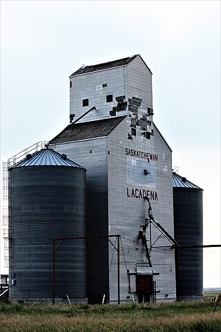
Lacadena is an unincorporated community in Lacadena Rural Municipality No. 228, Saskatchewan, Canada. The hamlet is located approximately 106 miles (171 km) northwest of Swift Current 29 miles (47 km) west of highway 4 on highway 342.

The Gingoog–Claveria–Villanueva Road is a 70.9-kilometer (44.1 mi), two-to-four lane national secondary highway, connecting the municipalities of Villanueva and Claveria, and the city of Gingoog in Misamis Oriental. Traversing through the mountain range that includes Mount Balatukan, it serves as a diversion road from the Butuan–Cagayan de Oro–Iligan Road.
Secondary Highway 514, commonly referred to as Highway 514, was a secondary highway in the Canadian province of Ontario. It was used on two separate routes from the 1950s to the 1990s: