In Greek mythology, the name Chloris appears in a variety of contexts. Some clearly refer to different characters; other stories may refer to the same Chloris, but disagree on details.
Æthelred or Ethelred is an Old English personal name and may refer to:

The Simple English Wikipedia is a modified English-language edition of Wikipedia written primarily in Basic English and Learning English. It is one of seven Wikipedias written in an Anglic language or English-based pidgin or creole. The site has the stated aim of providing an encyclopedia for "people with different needs, such as students, children, adults with learning difficulties, and people who are trying to learn English."
880 is the natural number following 879 and preceding 881.

Alberta Provincial Highway No. 36, commonly referred to as Highway 36 and officially named Veterans Memorial Highway, is a north-south highway in eastern Alberta, Canada that extends from Highway 4 near Warner to Highway 55 in Lac La Biche. In 2013 Lac La Biche County unsuccessfully lobbied the Government of Alberta to renumber Highway 881 to Highway 36 from Lac La Biche north to Highway 63 south of Fort McMurray.

Alberta Provincial Highway No. 63, commonly referred to as Highway 63, is a 434-kilometre (270 mi) highway in northern Alberta, Canada that connects the Athabasca oil sands and Fort McMurray to Edmonton via Highway 28. It begins as a two-lane road near the hamlet of Radway where it splits from Highway 28, running north through aspen parkland and farmland of north central Alberta. North of Boyle, it curves east to pass through the hamlet of Grassland and becomes divided west of Atmore where it again turns north, this time through heavy boreal forest and muskeg, particularly beyond Wandering River. Traffic levels significantly increase as Highway 63 bends through Fort McMurray, crossing the Athabasca River before connecting the city to the Syncrude and Suncor Energy plants further north. It ends approximately 16 km (10 mi) beyond a second crossing of the Athabasca River northeast of Fort McKay.

Minnesota State Highway 111 is a short 9.789-mile-long (15.754 km) highway in south-central Minnesota, which runs from its intersection with U.S. Highway 14 in Nicollet and continues north to its northern terminus at its intersection with State Highway 22 in New Sweden Township.

State Highway 188 (SH 188) is a state highway in the Coastal Bend region of Texas. It runs 41.327 miles (66.509 km) from Mathis east to Aransas Bay between Rockport and Port Aransas. SH 188 was established in its current form in 1992, after a previous incarnation existed from 1932 to 1942.
Highway 956, also known as the Garson Lake Road, is a provincial highway in the Canadian province of Saskatchewan. It runs from the Alberta border until Highway 155. It is about 44 kilometres (27 mi).
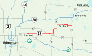
Alberta Provincial Highway No. 29, commonly referred to as Highway 29, is a 153-kilometre (95 mi) highway in east–central Alberta, Canada that connects Highway 15 near Lamont to Highway 41 north of Elk Point. It runs mostly west to east across aspen parkland through Hairy Hill, turning north through Duvernay, Brosseau, Foisy, St. Brides, and east to St. Paul before ending at Highway 41 approximately 9 km (5.6 mi) north of Elk Point, concurrent with Highways 36 and 45 for lengthy sections.

Alberta Provincial Highway No. 881, commonly referred to as Highway 881, is a highway split into two sections in northeast Alberta, Canada. Each section is over 200 kilometres (120 mi) in length; the southern portion runs from Highway 13 in Hardisty to Highway 55 northwest of Bonnyville, while the northern section stretches from Highway 55 in Lac La Biche to the south side of Fort McMurray, serving as an important alternate route to Highway 63. A 72-kilometre (45 mi) section of Highway 55 joins the two sections. Lac La Biche County is lobbying the Government of Alberta to renumber the section of Highway 881 between Lac La Biche and Fort McMurray to Highway 36.
Interbay is a neighborhood located in the South Tampa district of Tampa, Florida. The estimated population stands at 638.

The Lancer Ferry is a cable ferry in the Canadian province of Saskatchewan. The ferry crosses the South Saskatchewan River, linking the communities of Lancer with Eston and providing a connection between Highway 30 and Highway 32.
King's Highway 109, or Highway 109, is a former provincial highway in Ontario. It was used on two separate, unrelated routes during the 1950s and 1960s:
Ontario Highway 5A (1937–1953), as a former Connecting Link in the Ontario Provincial Highway Network, bypassed portions of Ontario Highway 5 within what is now Toronto. There were two discontinuous segments:
Secondary Highway 500, commonly referred to as Highway 500, was a secondary highway in the Canadian province of Ontario which was first designated in 1956. Its route was renumbered in 1964, becoming:
Secondary Highway 514, commonly referred to as Highway 514, was a secondary highway in the Canadian province of Ontario. It was used on two separate routes from the 1950s to the 1990s:
This page is based on this
Wikipedia article Text is available under the
CC BY-SA 4.0 license; additional terms may apply.
Images, videos and audio are available under their respective licenses.