The following highways are numbered 980:
| Preceded by 979 | Lists of highways 980 | Succeeded by 981 |

Interstate 980 (I-980) is a short 2.03-mile (3.27 km) auxiliary Interstate Highway entirely within Oakland in Northern California, connecting I-580 and State Route 24 (SR 24) to I-880 near Downtown Oakland. I-980 passes the Oakland Convention Center and near the famous Jack London Square. I-980 is commonly considered the dividing line between Downtown Oakland and West Oakland. The freeway was planned as the eastern approach to the Southern Crossing. It is officially known as the John B. Williams Freeway, after the former director of the city of Oakland's Office of Community Development.

State Route 24 is a heavily traveled east–west state highway in the U.S. state of California that serves the eastern side of the San Francisco Bay Area. A freeway throughout its entire length, it runs from the Interstate 580/Interstate 980 interchange in Oakland, and through the Caldecott Tunnel under the Berkeley Hills, to the Interstate 680 junction in Walnut Creek. It lies in Alameda County, where it is highly urban, and Contra Costa County, where it passes through wooded hillsides and suburbs. SR 24 is a major connection between the San Francisco–Oakland Bay Bridge/MacArthur Maze complex and the inland cities of the East Bay.

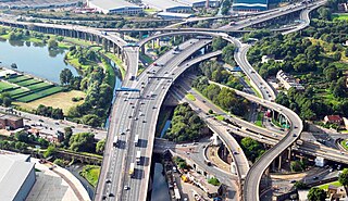
Spaghetti junction is a nickname sometimes given to a complex or massively intertwined road traffic interchange that is said to resemble a plate of spaghetti. Such interchanges may incorporate a variety of interchange design elements in order to maximize connectivity.
Kadamba is a Sanskrit word meaning dove and may refer to:

Maryland Route 980 is a designation used for a collection of five service roads in the U.S. state of Maryland along MD 4, four in Bristol and Waysons Corner in southern Anne Arundel County and one near Upper Marlboro in southern Prince George's County. MD 980 was assigned to the service roads constructed during the expansion of MD 4 to a four-lane divided highway in the early to mid-1960s.
Ali Sina may refer to:
Highway 980 is a provincial highway in the east central region of the Canadian province of Saskatchewan. It runs from Highway 3 near Armit until it transitions into Range Road 1304 at its southern terminus but not before passing through the Woody River Recreation Site and the community of Elbow Lake. It also connects with Highway 981. It is about 53 kilometres (33 mi) long.
Highway 981 is a provincial highway in the east central region of the Canadian province of Saskatchewan. It runs from Highway 980 until it transitions to Township Road 441. It is about 22 kilometres (14 mi) long.
Interstate 80 (I-80) is a transcontinental Interstate Highway in the United States, stretching from San Francisco, California, to Teaneck, New Jersey. In Indiana, it consists entirely of the following two highways:
69 may refer to:

Highway 980 is a state highway designation for all state maintained airport roads in Arkansas.
A roads may be

Pennsylvania Route 980 is a north–south 17-mile-long (27 km) state highway located in Washington and Allegheny counties in Pennsylvania. The highway begins at PA 519 south of Canonsburg. The northern terminus is at an interchange with U.S. Route 22 in North Fayette Township. PA 980 passes through the towns of Canonsburg, Venice, and McDonald. From West Pike Street in Canonsburg to US 22, PA 980 runs concurrently with BicyclePA Route A.
King's Highway 109, or Highway 109, is a former provincial highway in Ontario. It was used on two separate, unrelated routes during the 1950s and 1960s:
Ontario Highway 5A (1937–1953), as a former Connecting Link in the Ontario Provincial Highway Network, bypassed portions of Ontario Highway 5 within what is now Toronto. There were two discontinuous segments:
Expressway may refer to:
McAdams is an unincorporated community in Robinson Township, Washington County, Pennsylvania, United States. McAdams is located at the intersection of Pennsylvania Route 980 and North Branch Road, 2.2 miles (3.5 km) west-northwest of McDonald. The community is a coal town which was the site of the Pittsburgh Coal Company's Montour No. 9 mine, which closed in 1954. The Montour Trail passes through the community, as did a branch of the Montour Railroad during the mine's operation.
Secondary Highway 500, commonly referred to as Highway 500, was a secondary highway in the Canadian province of Ontario which was first designated in 1956. Its route was renumbered in 1964, becoming:
Secondary Highway 514, commonly referred to as Highway 514, was a secondary highway in the Canadian province of Ontario. It was used on two separate routes from the 1950s to the 1990s: