The name Tabari or al-Tabari means simply "from Tabaristan", an Iranian province corresponding to parts of modern Iranian province of Mazandaran.
Diet of Speyer or Diet of Spires refers to any of the sessions of the imperial diets of the Holy Roman Empire, of which 50 took place between 838 and 1570 in the city of Speyer (Spires), now in Germany. The most famous sessions occurred in 1526 and 1529.
Babak or Babek may refer to:

Dixie Highway in Palm Beach and Broward counties carries two segments of the State Road 811 designation by Florida Department of Transportation, as well as the local County Road 811 in southeast Florida. The entire road comprises a section of the Dixie Highway, a National Auto Trail which eventually became a former routing of U.S. Route 1 after the route was shifted east to Federal Highway. One segment of SR 811 is in Broward County and the other is in Palm Beach County, Florida. The segments of SR 811 are supplemented by three shorter segments of CR 811, one of which is unsigned.

Sunrise Boulevard is a 15.6 miles (25.1 km) long east–west highway serving central Broward County mostly designated State Road 838. The road begins at an interchange with the Sawgrass Expressway in Sunrise and continues east to North Ocean Boulevard in Fort Lauderdale, next to Hugh Taylor Birch State Park. For 0.91 miles (1.46 km) in downtown Fort Lauderdale, SR 838 overlaps U.S. Route 1.
Interstate 80 (I-80) is a transcontinental Interstate Highway in the United States, stretching from San Francisco, California, to Teaneck, New Jersey. In Indiana, it consists entirely of the following two highways:
Gaon may have originated as a shortened version of "Rosh Yeshivat Ge'on Ya'akov", although there are alternative explanations. In Ancient Hebrew, it referred to arrogance and haughty pride and later became known as a general term for pride, both the positive and negative forms. Today, it may refer to:
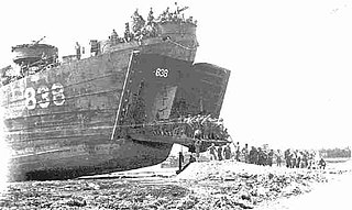
USS Hunterdon County (LST-838) was an LST-542-class tank landing ship built for the United States Navy during World War II, and later reconfigured and recommissioned for riverine warfare during the Vietnam War. Named after Hunterdon County, New Jersey, she was the only U.S. Naval vessel to bear the name.
The Dinosaur Trail is a circular tourist route in the province of Alberta, Canada, located in the Canadian badlands paralleling the Red Deer River on both sides, from Drumheller to the Bleriot Ferry. It is divided in two segments, with the South Dinosaur Trail following the south side of the river and uses portions of Highway 575 and Highway 837, while North Dinosaur Trail follows the north side of the river and is the entirety of Highway 838. The north and south segments of Dinosaur Trail are connected by the Highway 9 / Highway 56 concurrency within Drumheller.
Alberta Provincial Highway No. 838, commonly referred to as Highway 838, is a short highway in central Alberta, Canada. It runs from Highway 837 across the Red Deer River on the free, cable-operated Bleriot Ferry to Highway 9 / Highway 56 in Drumheller. Outside of Drumheller, Highway 838 does not pass through any communities. All of Highway 838 is part of the Dinosaur Trail and is known as North Dinosaur Trail.
State Highway 76 is a State Highway in Kerala, India that starts in Kuranchery and ends in Kechery. The highway is 12.838 km long.

The Rural Municipality of Willow Creek No. 458 is a rural municipality (RM) in the Canadian province of Saskatchewan within Census Division No. 14 and SARM Division No. 4.
King's Highway 109, or Highway 109, is a former provincial highway in Ontario. It was used on two separate, unrelated routes during the 1950s and 1960s:
Ontario Highway 5A (1937–1953), as a former Connecting Link in the Ontario Provincial Highway Network, bypassed portions of Ontario Highway 5 within what is now Toronto. There were two discontinuous segments:
Secondary Highway 500, commonly referred to as Highway 500, was a secondary highway in the Canadian province of Ontario which was first designated in 1956. Its route was renumbered in 1964, becoming:
Secondary Highway 514, commonly referred to as Highway 514, was a secondary highway in the Canadian province of Ontario. It was used on two separate routes from the 1950s to the 1990s:
This page is based on this
Wikipedia article Text is available under the
CC BY-SA 4.0 license; additional terms may apply.
Images, videos and audio are available under their respective licenses.