List of tourist drives in Queensland

Last updated

List of tourist drives in Queensland includes numbered and un-numbered routes. Most routes have an official name, but some have been named in this article based on the region in which they occur. Some duplication of numbers exists where the Queensland Government and a local authority have each chosen the same number for use in different regions. General information about tourist drives in Queensland can be found here: .

Contents

Unless stated otherwise, all distance and road name information in this article is derived from Google Maps.

Strategic touring routes

State Strategic Touring Routes are road routes in Queensland, Australia, which have been identified as significant to motoring tourists. These are the primary routes used by tourists as they provide the connections between popular tourist locations, and consequently have high volumes of tourist traffic. Standardised road signage is used to identify the route itself, with "Welcome to" signage at towns and districts of interest to tourists, as well as "turn off" signage to natural attractions. [1]

RouteComponent roads and streetsFromViaToLengthNotes
↑ (Top)

Adventure Way [2]
Brisbane Toowoomba, Dalby, St George, Cunnamulla, Thargomindah Durham 1,152 km (715.8 mi)Continues to Innamincka, South Australia. Length (from reference) is from Brisbane to Innamincka.

Australia's Country Way [3]
Rockhampton Monto, Wondai, Kingaroy, Yarraman, Toowoomba, Warwick Wallangarra 1,615 km (1,003.5 mi)Continues to Sydney, New South Wales. Length (from reference) is from Rockhampton to Sydney.

Capricorn Way [4]
Capricorn Highway Rockhampton Duaringa , Blackwater , Emerald , The Gemfields, Alpha Barcaldine 579 km (359.8 mi)Length is from reference.

Great Inland Way [5]
Hebel St George, Rolleston , Springsure , Conjuboy , Evelyn, Gordonvale Cairns Continues from Hebel to Sydney.

Leichhardt Way [6]
Goondiwindi Miles , Banana , Dululu , Westwood RockhamptonContinues from Goondiwindi to Melbourne, Victoria.

Matilda Way [7]
Karumba Howitt , Cloncurry , Longreach , Augathella Barringun Continues to Bourke, New South Wales.

Overlanders Way [8]
Townsville Charters Towers , Hughenden , Richmond , Julia Creek, Cloncurry, Mount Isa Camooweal Continues to Tennant Creek, Northern Territory.

Pacific Coast Way [9]
CairnsTownsville, Mackay, Gympie, Brisbane Coolangatta Continues to Sydney.

Savannah Way [10]
Cairns
  • Atherton
  • Mt Surprise
  • Georgetown
  • Croydon
  • Normanton
  • Burketown
  • Doomadgee
Hells Gate Roadhouse

Continues to Broome, Western Australia. Alternate Routes: [11]

  • 40 Mile Scrub, Forsayth, Einasleigh, Georgetown
  • Mt Surprise, Chillagoe, Normanton
  • Burketown, Boodjamulla (Lawn Hill), Doomadgee

Warrego Way [12]
Brisbane Charleville Birdsville 1,578 km (980.5 mi)Length from reference.

Un-numbered tourist drives

RouteComponent roads and streetsFromViaToLengthNotes
↑ (Top)

Brisbane Valley Drive
  • AUS Alphanumeric Route A17.svg Brisbane Valley Highway
  • AUS Alphanumeric Route A17.svgAustralian state route 85.svg D'Aguilar Highway
Blacksoil
  • Fernvale
  • Esk
  • Toogoolawah
  • Blackbutt
Yarraman

The Canecutter Way [13]
Kurrimine Beach
  • Mena Creek
  • Paronella Park
  • Mamu Tropical Skywalk
Innisfail

Cobb and Co Tourist Drive [14] [15]
Ipswich Grandchester Toowoomba 120 km (74.6 mi)Length from reference.


Dingo Barrier Fence Drive [16]
  • Australian state route 82.svg Dalby Jandowae Road
  • Lyndley Connection Road
  • Lyndley Lane
  • Fletchers Road
Jandowae 110 km (68.4 mi)


Granite Belt Drive [17]
Granite Belt Drive Dalveen Cottonvale, Thulimbah The Summit 12 km (7.5 mi)Loop route from and to New England Highway. Length from reference. Signed as Australian Tourist Drive 3.svg

Great Barrier Reef Tourist Drive [18]
Smithfield, Cairns
  • Rex Lookout
  • Four Mile Beach, Port Douglas
  • Mossman Gorge
  • Alexandra Lookout
Cape Tribulation125 km (77.7 mi)


Great Bunya Drive [19]
  • AUS Alphanumeric Route A21.svg Toowoomba Connection Road
  • AUS Alphanumeric Route A2.svg Warrego Highway
  • Australian state route 82.svg Dalby Jandowae Road
  • MacAllister Bell Road
  • Australian state route 49.svg Bunya Highway
  • Bunya Mountains Road
  • Maidenwell Bunya Mountain Road
  • Kingaroy Cooyar Road
  • Nanango Tarong Road
  • AUS Alphanumeric Route A3.svgAustralian state route 96.svg D’Aguilar Highway
  • Australian state route 49.svg Bunya Highway
  • Australian state route 49.svg Wide Bay Highway
  • AUS Alphanumeric Route A1.svg Bruce Highway
Toowoomba Dalby, Bunya Mountains, Nanango, Kingaroy, Wondai, Murgon, Goomeri Gympie 324 km (201.3 mi)Length from reference.


Hibiscus Coast Tourist Drive [20]
  • AUS Alphanumeric Route A1.svg Bruce Highway
  • Mount Ossa–Seaforth Road
  • Yakapari–Seaforth Road
  • Cape Hillsborough Road
  • Kuttabul–Mount Jukes Road
The Leap (Mackay)Calen
  • Mount Jukes
  • Seaforth
  • Haliday Bay
  • Cape Hillsborough
  • Kuttabul

Mission Beach Drive
  • Tully Mission Beach Road
  • El Arish Mission Beach Road
Tully
  • Mission Beach
El Arish


Northern Moreton Bay Tourist Drive [21]
  • Australian state route 26.svgAustralian state route 71.svg Anzac Avenue
  • Klinger Road
  • Boardman Road
  • Griffith Road
  • Newport Drive
  • Endeavour Esplanade
  • Oyster Point Esplanade
  • Thurecht Parade
  • Bird O'Passage Parade
  • Reef Point Esplanade
  • Second Avenue (Scarborough)
  • Fortune Street
  • Australian state route 27.svg Fifth Avenue
  • Australian state route 27.svg Landsborough Avenue
  • Kennedy Esplanade
  • Flinders Parade
  • Griffith Road
  • Prince Edward Parade
  • Redcliffe Parade
  • Marine Parade
  • Margate Parade
  • Whytecliffe Parade
  • Gayundah Esplanade
  • Lilla Street
  • Woodcliffe Crescent
  • Oxley Avenue
  • Australian state route 27.svg Hornibrook Esplanade
  • Australian state route 26.svgAustralian state route 27.svg Houghton Highway
  • Australian state route 27.svg Hornibrook Highway
  • Australian state route 27.svg Beaconsfield Terrace
  • Nineteenth Avenue
  • Flinders Parade
  • Cliff Street
  • Second Avenue (Sandgate)
  • Brighton Road
  • Bowser Parade (northbound only)
  • Seymour Street
  • Eagle Terrace
  • Park Parade
  • Swan Street
  • Shorncliffe Parade
  • Allpass Parade
  • Sinbad Street
  • Palm Avenue
  • Rainbow Street
  • Australian state route 27.svg Board Street
Rothwell Redcliffe Deagon 36 km (22.4 mi)Length from reference.


Pioneer Valley Drive [22] [23]
Walkerston (Mackay)Broken River, Eungella National Park Marian, (Eton), (Kuttabul), Kinchant Dam, Mirani, Cattle Creek, Pinnacle, Finch Hatton Gorge, Eungella122km


Shearer’s Way [24]
Stanthorpe Glenlyon Texas Extension of Tourist Drive 8 from Glenlyon Dam to Texas. Signed as Australian Tourist Drive 8.svg


Southern Moreton Bay Tourist Drive [25]
Wynnum Cleveland Redlands 78 km (48.5 mi)Length from reference.


Warrego Way through Gatton
[26]
  • Eastern Drive
  • Railway Street
  • Western Drive
  • Gatton Helidon Road
Gatton Grantham Helidon Former alignment of the Warrego Highway. Part of it is signed as Australian state route 80.svg

Numbered tourist drives

RouteComponent roads and streetsFromViaToLengthNotes
↑ (Top)

Australian Tourist Drive 1.svg
Tourist Drive 1
Settlers’ Route [27] [15] [28]
  • Warwick Killarney Road
  • Yangan Killarney Road
  • Warwick Yangan Road
Warwick Killarney Warwick72 km (44.7 mi)Loop route

Australian Tourist Drive 2.svg
Tourist Drive 2
Paradise Dam Tourist Drive [29]
  • Goodnight Road
  • Kalliwa Road
Goodnight Paradise Dam 46 km (28.6 mi)Some sections are 4WD Only, Goes through Goodnight National Park

Australian Tourist Drive 3.svg
Tourist Drive 3
Border Rivers [30]
  • Kildonan Road
  • Yelarbon Keetah Road
Goondiwindi Yelarbon

Australian Tourist Drive 3.svg
Tourist Drive 3
Cambooya [15]
  • AUS Alphanumeric Route A139.svg Toowoomba Athol Road
  • Old Wyreema Road
  • Toowoomba Karara Road
  • Australian state route 48.svg Cambooya Connection Road
  • New England Highway
  • Hodgson Vale Road
  • Sawpit Road
  • Wilsons Road
  • Preston Boundary Road
  • Boundary Road
  • New England Highway
  • Drayton Connection Road
Toowoomba Cambooya ToowoombaLoop route

Australian Tourist Drive 4.svg
Tourist Drive 4
Darling Downs [15]
  • Cudmores Road
  • McGovern Road
  • Nunkulla Road
  • Felton Clifton Road
  • Mount Kent Boundary Road
  • Felton Clifton Road
  • Gatton Clifton Road
  • New England Highway
  • Greenmount Hirstvale Road
  • Budgee Road
  • Greenmount Budgee Road
  • Greenmount Clifton Road
  • Greenmount Etonvale Road
  • New England Highway
Cambooya Clifton CambooyaLoop route. Much longer southern extension of Tourist Drive 3 (Cambooya)

Australian Tourist Drive 4.svg
Tourist Drive 4
Fairbairn Dam
  • Selma Road
  • Fairbairn Dam Road
Emerald Fairbairn Dam Loops back to Emerald via AUS Alphanumeric Route A7.svg Gregory Hwy, Central Highlands Tourist Drive 4

Australian Tourist Drive 5.svg
Tourist Drive 5
Amiens [31]
Stanthorpe Amiens Thulimbah

Australian Tourist Drive 6.svg
Tourist Drive 6
Bauple Tourist Drive
  • Bauple–Woolooga Road
  • Bauple Drive
A1 Bruce HighwayBaupleA1 Bruce Highway11 km (6.8 mi)

Australian Tourist Drive 6.svg
Tourist Drive 6
Highland Drive [32] [31]
  • Sugarloaf Road
  • Eukey Road
Stanthorpe Eukey Ballandean

Australian Tourist Drive 7.svg
Tourist Drive 7
Mount Coot–tha [33]
Toowong Mount Coot-tha & Bardon Toowong7 km (4.3 mi)Loop route

Australian Tourist Drive 7.svg
Tourist Drive 7
Oracle’s Way [34] [31]
  • Amosfield Road
  • Mount Lindesay Road
  • Logan Street
  • Naas Street
  • New England Highway
  • Wallangarra Road
StanthorpeAmosfield, NSW Tenterfield, NSW Loop route. Enter NSW at Dalcouth.

Australian Tourist Drive 7.svg
Tourist Drive 7
Anakie-Sapphire [15]
  • Anakie Sapphire Road
Anakie Siding Sapphire Central Central Highlands Tourist Drive 7

Australian Tourist Drive 8.svg
Tourist Drive 8
Glenlyon Dam [31]
Stanthorpe Glenlyon Mingoola

Australian Tourist Drive 8.svg
Tourist Drive 8
Tamborine Mountain [35]
  • Australian state route 95.svg Tamborine Oxenford Road
  • Australian state route 95.svg Macdonnell Road
  • Australian state route 95.svg Long Road
  • Lahey Road
  • Main Western Road
  • Australian state route 95.svg Geissmann Drive (part)
  • Australian state route 95.svg Tamborine Mountain Road
  • Australian state route 92.svg Beaudesert Beenleigh Road
  • Australian state route 90.svg Mundoolun Connection Road
  • Australian state route 90.svg Beaudesert–Nerang Road
  • Australian state route 90.svg Mount Nathan Road
Oxenford Mount Tamborine, Canungra Nerang Also signed at the Junction of the Mount Lindsey Hwy and Beaudesert Nerang Road in Beaudesert

Australian Tourist Drive 8.svg
Tourist Drive 8
Arcadia Valley Loop [36]
  • AUS Alphanumeric Route A7.svg Carnaravon Highway
  • Arcadia Valley Road
  • Mulcahys Road
Baffle West Arcadia Valley Loops Route

Australian Tourist Drive 8.svg
Tourist Drive 8
Mount Nebo [37]
  • Australian state route 31.svg Mount Nebo Road
The Gap Mount Nebo Goes Through Mount Nebo, End at Intersection with Tourist Drive 9

Australian Tourist Drive 8.svg
Tourist Drive 8
Clermont-Goldfields
  • Clermont-Rubyvale Road
Clermont Rubyvale Central Highlands Tourist Drive 8

Australian Tourist Drive 9.svg
Tourist Drive 9
Mount Glorious [38]
  • Australian state route 22.svg Samford Road
  • Mount Glorious Road
  • Australian state route 31.svg Mount Glorious Road
  • Australian state route 31.svg Northbrook Parkway
Ferny Hills Mount Glorious Lake Wivenhoe

Australian Tourist Drive 10.svg
Tourist Drive 10
Capricorn Coast [39]
Berserker Emu Park and Yeppoon Berserker 103 km (64.0 mi)This is a circular route from and to the northern end of the Fitzroy Bridge in Rockhampton. It is also signed as Australian state route 4.svg.

Australian Tourist Drive 11.svg
Tourist Drive 11
The Sunflower Route [40] [15] [28]
  • Rosehill Road
  • Warwick Allora Road
  • Alldridge Road
  • East Street
  • Forde Street
  • Allora Drive
  • New England Highway
Warwick Allora WarwickLoop route

Australian Tourist Drive 12.svg
Tourist Drive 12
Fraser Coast [41]
  • Gympie Road
  • Ferry Street
  • Ann Street
  • Lions Drive
  • Queen Street
  • Neptune Street
  • Alice Street
  • Pallas Street
  • Kent Street
  • Lennox Street
  • Woodstock Street
  • Saltwater Creek Road
  • Maryborough–Hervey Bay Road
  • Booral Road
  • Elizabeth Street
  • Boat Harbour Drive
  • Charlton Esplanade
  • Miller Street
  • Pulgul Street
  • Kent Street
  • King Street
  • Elizabeth Street
  • The Esplanade
  • Martin Street
  • Tooth Street
  • Old Maryborough Road
  • Maryborough–Hervey Bay Road
  • Pialba–Burrum Heads Road
  • Burrum Heads Road
  • Old Bruce Highway
  • Steley Street
  • William Street
MaryboroughHervey BayHowardFrom Bruce Highway, Tinana to Bruce Highway, Howard

Australian Tourist Drive 12.svg
Tourist Drive 12
The Sprint Route [42] [15] [28]
Warwick Leyburn WarwickLoop route

Australian Tourist Drive 14.svg
Tourist Drive 14
The Cedar Route [43] [15] [28]
  • Warwick Yangan Road
  • Kay Road
  • Freestone Road
  • Cunningham Highway
  • Clintonvale Goomburra Road
  • Goomburra Road
  • New England Highway
Warwick Goomburra WarwickLoop route

Australian Tourist Drive 14.svg
Tourist Drive 14
  • Mulligan Highway
MareebaMount MolloyPart of the Great Barrier Reef Tourist Drive

Australian Tourist Drive 16.svg
Tourist Drive 16
Scenic Rim [37] [15]
  • Queen Street
  • Rosewood Marburg Road
  • Waight Street
  • John Street
  • School Street
  • Ipswich Rosewood Road
  • Cunningham Highway
  • Middle Road
  • Peak Crossing Churchbank Weir Road
  • Australian state route 93.svg Ipswich–Boonah Road
  • Australian state route 93.svg Boonah–Rathdowney Road
  • Mount Lindesay Highway
  • Australian state route 90.svg Beaudesert Nerang Road
  • Australian state route 90.svg Beaudesert Beenleigh Road
Marburg Rosewood, Boonah, Rarhdowney, Beaudesert Tamborine Ends at an intersection with Tourist Drive 8. Left to Tamborine village, right to Canungra.
Australian Tourist Drive 21.svg
Tourist Drive 21
The Falls Drive

[44] [45]

  • Acacia Street
  • Border Road
  • Spring Creek Road
Killarney
  • Browns Falls
  • Daggs Falls
  • Queen Mary Falls
  • Carrs Lookout
  • The Head
  • Croftby
CoochinJoins Australian Tourist Drive 16.svg near Coochin. Onward options:
  • North to Boonah, south to Rathdowney.
  • Loop route: returning on same road
  • Loop route: return via Condamine River Road (may be 4WD only)

Australian Tourist Drive 22.svg
Tourist Drive 22
Kenilworth

[46] [15]

  • Eumundi Kenilworth Road
  • Maleny Kenilworth Road
  • Macadamia Drive
Eumundi Kenilworth Maleny

Australian Tourist Drive 23.svg
Tourist Drive 23
Blackall Range [47] [48]
  • Landsborough Maleny Road
  • Mountain View Road
  • Maleny Stanley River Road
  • Coral Street
  • Bunya Street
  • Landsborough Maleny Road
  • Maleny Montville Road
  • Balmoral Road
  • Main Street, Montville
  • Montville Mapleton Road
  • Flaxton Drive
  • Nambour Mapleton Road
  • Netherton Street
  • National Park Road
  • Bli Bli Road
Landsborough Maleny Nambour

Australian Tourist Drive 24.svg
Tourist Drive 24
Glass House Mountains [49] [48]
Steve Irwin Way Glenview Landsborough Beerwah Also signed as Australian state route 6.svg. For an extension to this drive that takes in much more of the Glass House Mountains, see here

Australian Tourist Drive 25.svg
Tourist Drive 25
Tanawha-Forest Glen Tourist Drive
  • Tanawha Tourist Drive
  • Owen Creek Road
Tanawha Forest Glen

Australian Tourist Drive 29.svg
Tourist Drive 29
Mount Mee [47] [48]
Dayboro Mount Mee Woodford Follows Australian state route 58.svg from Dayboro to D'Aguilar then follows Australian state route 85.svg to Woodford

Australian Tourist Drive 40.svg
Tourist Drive 40
Gympie City [50]
  • Australian state route 15.svg Brisbane Road
  • Red Hill Road
  • Apollonian Vale
  • Caledonian Hill
  • Calton Hill
  • Young Street
  • River Road
Gympie Goes through Central Gympie

Australian Tourist Drive 41.svg
Tourist Drive 41
Opportunity Drive [15]
  • Gatton Clifton Road
  • Felton Clifton Road
  • Sister Kenny Street
  • Nobby Connection Road
Nobby Clifton Spring Creek Runs Parallel with Australian Tourist Drive 4.svg through most of the Route

Australian Tourist Drive 42.svg
Tourist Drive 42
Mary Valley [51] [15]
  • Kenilworth–Skyring Creek Road
  • Tuchekoi Road
  • Mary Valley Road
  • Yabba Creek Road
  • Kandanga–Imbil Road
Gympie Imbil Tuchekoi 49 km (30.4 mi)

Australian Tourist Drive 43.svg
Tourist Drive 43
Cooloola-Fraser Island
  • Tin Can Bay Road
  • Rainbow Beach Road
  • Clarkson Drive
  • Inskip Avenue
  • Inskip Point Road
Tin Can Bay Rainbow Beach Fraser Island Australian Tourist Drive 43.svg Ferry Crosses to Fraser Island

See also

Related Research Articles

<span class="mw-page-title-main">Bruce Highway</span> Highway in Queensland, Australia

The Bruce Highway is a major highway in Queensland, Australia. Commencing in the state capital, Brisbane, it passes through areas close to the eastern coast on its way to Cairns in Far North Queensland. The route is part of the Australian National Highway and also part of Highway 1, the longest highway route in Australia. Its length is approximately 1,679 kilometres (1,043 mi); it is entirely sealed with bitumen. The highway is named after a popular former Queensland and federal politician, Harry Bruce. Bruce was the state Minister for Works in the mid-1930s when the highway was named after him. The highway once passed through Brisbane, but was truncated at Bald Hills when the Gateway Motorway became National Highway 1 upon its opening in December 1986.

<span class="mw-page-title-main">Peak Downs Highway</span> Highway in Queensland, Australia

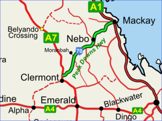
The Peak Downs Highway links the towns of Mackay and Clermont in the Australian state of Queensland. It represents the main link between Queensland's Whitsunday Coast and the Central West region of the state. The highway runs for a total length of 266 kilometres (165 mi), before joining the Gregory Highway south to Clermont, a total of 283 kilometres (176 mi). Major settlements served by this route include Walkerston, Nebo, Moranbah and Clermont.

<span class="mw-page-title-main">North Queensland</span> Region in Queensland, Australia

North Queensland or the Northern Region is the northern part of the Australian state of Queensland that lies just south of Far North Queensland. Queensland is a massive state, larger than many countries, and its tropical northern part has been historically remote and undeveloped, resulting in a distinctive regional character and identity.

<span class="mw-page-title-main">Tanawha, Queensland</span> Suburb of Sunshine Coast, Queensland, Australia

Tanawha is a rural locality in the Sunshine Coast Region, Queensland, Australia. The name Tanawha is believed to be a Māori language word referring to a legendary New Zealand monster. For statistical purposes, it is regarded as a subub of Buderim.

<span class="mw-page-title-main">Esk–Hampton Road</span>

The Esk–Hampton Road is a state highway in Queensland. It leaves the Brisbane Valley Highway at Esk and travels in a westerly direction for 45.7 km (28 mi) until it reaches the New England Highway at Hampton, where it ends. This road is part of State Route 85, which extends for over 570 km (354 mi) from Bribie Island to Nindigully, duplexing with the Brisbane Valley Highway from the D'Aguilar Highway to Esk, the New England Highway from Hampton to Toowoomba, the Gore Highway from Toowoomba to the Leichhardt Highway, and the southern 19 km (12 mi) section of the Leichhardt Highway to Goondiwindi.

Koumala is a rural town and coastal locality in the Mackay Region, Queensland, Australia. In the 2016 census, the locality of Koumala had a population of 831 people.

Blacks Beach is a coastal suburb, one of the "northern beaches" of the city of Mackay in the Mackay Region, Queensland, Australia. In the 2016 census Blacks Beach had a population of 3,861 people.

<span class="mw-page-title-main">Suttor Developmental Road</span>

The Suttor Developmental Road is a state-controlled regional road part of which is rated as a local road of regional significance (LRRS). It is a highway in the east of the Australian state of Queensland. It runs in SE–NW direction and has a length of 162 km. It connects the Peak Downs Highway with the Bowen Developmental Road. It is signed as State Route 11.

Yalboroo is a rural town and locality in the Mackay Region, Queensland, Australia. In the 2016 census, the locality of Yalboroo had a population of 170 people.

The Pacific Coast Way is an Australian road route from Sydney, New South Wales to Cairns in Queensland. It has been designated by the Queensland Government as a State Strategic Touring Route.

Ooralea is a southern suburb of Mackay in the Mackay Region, Queensland, Australia. In the 2016 census, Ooralea had a population of 3,366 people.

The Falls is a rural locality in the Southern Downs Region, Queensland, Australia. In the 2016 census The Falls had a population of 70 people.

Rockhampton–Emu Park Road is a continuous 44.1 kilometres (27.4 mi) road route in the Rockhampton and Livingstone local government areas of Queensland, Australia. The route is designated as State Route 4 (Regional) and Tourist Drive 10. It is a state-controlled regional road.

Ipswich–Boonah–Rathdowney Road is a continuous 87.8 kilometres (54.6 mi) road route in the Ipswich and Scenic Rim regions of Queensland, Australia. It has two official names, Ipswich–Boonah Road and Boonah–Rathdowney Road. The entire route is signed as State Route 93, and much of it is also part of Tourist Drive 16.

Stanthorpe–Texas–Inglewood Road is a continuous 152.8 kilometres (94.9 mi) road route in the Southern Downs and Goondiwindi regions of Queensland, Australia. It has two official names: Stanthorpe–Texas Road and Inglewood–Texas Road. The entire route is signed as State Route 89. Tourist Drives 5 (Amiens) and 8 and the Shearer's Way all start in Stanthorpe and run concurrent with this road for part of its length.

Gympie–Brooloo–Kenilworth Road is a continuous 51.6 kilometres (32.1 mi) road route in the Gympie and Sunshine Coast regions of Queensland, Australia. It has two official names, Gympie–Brooloo Road and Kenilworth–Brooloo Road. The entire route is signed as State Route 51.

Mackay–Eungella Road is a continuous 69.7 kilometres (43.3 mi) road route in the Mackay region of Queensland, Australia. The entire route is signed as State Route 64. It is a state-controlled regional road. At the western end it becomes Eungella Dam Road.

Rockhampton–Yeppoon Road is a non-continuous 39.8 kilometres (24.7 mi) road route in the Rockhampton and Livingstone local government areas of Queensland, Australia. Most of the route is designated as State Route 4 (Regional) and Tourist Drive 10. It is a state-controlled regional road.

Glass House Mountains Road is a continuous 30.4-kilometre (18.9 mi) road route in the Moreton Bay and Sunshine Coast local government areas of Queensland, Australia. Part of it is designated as part of State Route 6. It is a state-controlled road, part regional and part district.

References

  1. "Driving Experiences (State Strategic Touring Routes and Tourist Drives)" (PDF). Department of Transport and Main Roads. Queensland Government. February 2016. Archived (PDF) from the original on 27 May 2017. Retrieved 27 May 2017. Licensed CC BY 3.0 AU.
  2. "Adventure Way - Queensland". Queensland Government . Archived from the original on 11 March 2017. Retrieved 27 May 2017.
  3. "Australia's Country Way". Queensland Government . Archived from the original on 9 June 2017. Retrieved 9 June 2017.
  4. "Capricorn Way". Queensland Government . Archived from the original on 9 June 2017. Retrieved 9 June 2017.
  5. "Great Inland Way" (PDF). Royal Automobile Club of Queensland . Retrieved 17 July 2017.
  6. "Leichhardt Highway Melbourne to Rockhampton". Royal Automobile Club of Queensland . Retrieved 15 July 2017.
  7. "Matilda Way". Outback Queensland. Retrieved 18 July 2017.
  8. "Overlanders Way". Outback Queensland. Retrieved 19 July 2017.
  9. "Pacific Coast Way". Tourism and Events Queensland. Retrieved 19 July 2017.
  10. Hema, Maps (2007). Australia Road and 4WD Atlas (Map). Eight Mile Plains Queensland: Hema Maps. pp. 11–12. ISBN   978-1-86500-456-3.
  11. "Savannah Way". 30 July 2022.
  12. "Warrego Way". Queensland Government . Archived from the original on 9 June 2017. Retrieved 9 June 2017.
  13. "The Canecutter Way". tropicalnorthqueensland.org.au. Retrieved 9 July 2022.
  14. "Cobb & Co Tourist Drive". Queensland.com. Retrieved 11 November 2020.
  15. 1 2 3 4 5 6 7 8 9 10 11 12 "South-east Queensland coast (Map 7)" (PDF). Queensland Government. 28 June 2016. Retrieved 9 November 2020.
  16. "Wild Dog Barrier Fence Tour". Queensland Government. Retrieved 29 January 2024.
  17. "Granite Belt Drive". Southern Downs Regional Council. Retrieved 8 November 2020.
  18. "Great Barrier Reef Drive roadsign". 2022. Retrieved 19 July 2022.
  19. "The Great Bunya Drive". Discover South Burnett. Retrieved 8 November 2020.
  20. "Sign showing Mackay area tourist drives". Mackay Regional Council. 27 June 2022. Retrieved 27 June 2022.
  21. "Northern Moreton Bay Tourist Drive". Queensland Government. Retrieved 8 November 2020.
  22. "Sign showing Mackay area tourist drives". Mackay Regional Council. 27 June 2022. Retrieved 27 June 2022.
  23. "Pioneer Valley Driving Itinerary (Mackay - Finch Hatton - Eungella National Park)" (PDF). Mackay Tourism. Retrieved 4 July 2022.
  24. "Shearer's Way". Southern Downs Regional Council. Retrieved 8 November 2020.
  25. "Southern Moreton Bay Tourist Drive". Queensland Government. Retrieved 8 November 2020.
  26. "Confusion over Warrego Way in Gatton". Gatton Star. 4 July 2018. Retrieved 11 November 2020.
  27. "Settlers' Route". Southern Downs Regional Council. Retrieved 9 November 2020.
  28. 1 2 3 4 "Scenic Country drives from Warwick". Queensland.com. Retrieved 11 November 2020.
  29. "Paradise Dam Tourist Drive (Good Night Scrub National Park)". brownsigns.net.au. 8 January 2019. Retrieved 9 January 2024.
  30. "Border Rivers Tourist Drive". Goondiwindi Region. 2 September 2020. Retrieved 22 November 2020.
  31. 1 2 3 4 "South-west Queensland Downs (map 6)" (PDF). Queensland Government. 28 June 2016. Retrieved 9 November 2020.
  32. "Highland Drive". Southern Downs Regional Council. Retrieved 9 November 2020.
  33. "Mount Coot-tha Tourist Drive". Road Photos & Information: Queensland. 3 November 2019. Retrieved 10 November 2020.
  34. "Oracle's Way". Southern Downs Regional Council. Retrieved 9 November 2020.
  35. "Gold Coast and surrounding areas (map 7D)" (PDF). Queensland Government. 28 June 2016. Retrieved 10 November 2020.
  36. "The Arcadia Valley Loop". Queensland Government. 28 June 2016. Retrieved 29 January 2024.
  37. 1 2 "Brisbane and surrounding areas (map 7C)" (PDF). Queensland Government. 28 June 2016. Retrieved 10 November 2020.
  38. "Mount Glorious Tourist Drive". Road Photos & Information: Queensland. 3 November 2019. Retrieved 10 November 2020.
  39. "Capricorn and southern Queensland coast (maps 4 and 5)" (PDF). Queensland Government. 28 June 2016. Retrieved 11 November 2020.
  40. "The Sunflower Route". Southern Downs Regional Council. Retrieved 9 November 2020.
  41. "Fraser Coast not so pretty". Fraser Coast Chronicle. 16 November 2010. Retrieved 11 November 2020.
  42. "The Sprint Route". Southern Downs Regional Council. Retrieved 9 November 2020.
  43. "The Cedar Route". Southern Downs Regional Council. Retrieved 9 November 2020.
  44. "The Falls Drive". Southern Downs Regional Council. Retrieved 9 November 2020.
  45. "Condamine River Road". Queensland and beyond. 21 May 2018. Retrieved 11 November 2020.
  46. "Kenilworth Tourist Drive". Road Photos & Information: Queensland. 3 November 2019. Retrieved 10 November 2020.
  47. 1 2 "Blackall Range Tourist Drive". Road Photos & Information: Queensland. 17 December 2019. Retrieved 10 November 2020.
  48. 1 2 3 "Caloundra and surrounding areas (map7B)" (PDF). Queensland Government. 28 June 2016. Retrieved 11 November 2020.
  49. "Glass House Mountains Tourist Drive". Road Photos & Information: Queensland. 3 November 2019. Retrieved 10 November 2020.
  50. "Gympie City Tourist Drive". Queensland Government. Retrieved 29 January 2024.
  51. "Mary Valley Tourist Drive". Road Photos & Information: Queensland. 3 November 2019. Retrieved 10 November 2020.