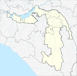
Maykop Майкоп | |
---|---|
Other transcription(s) | |
• Adyghe | Мыекъуапэ |
• Ubykh | Гъакъыва |
From the top to bottom, Skyline of Maykop, Maykop Train Station, Maykop Grand Mosque, Maykop Brewery | |
Coordinates: 44°36′N40°05′E / 44.600°N 40.083°E | |
Country | Russia |
Federal subject | Adygea [1] |
Founded | May 1857 |
City status since | 1870 |
Government | |
• Body | Council of People's Deputies |
• Head | Nikolay Pivovarov |
Area | |
• Total | 58.62 km2 (22.63 sq mi) |
Elevation | 220 m (720 ft) |
Population | |
• Total | 144,249 |
• Estimate (2018) [4] | 141,970 (−1.6%) |
• Rank | 120th in 2010 |
• Density | 2,500/km2 (6,400/sq mi) |
• Subordinated to | Maykop Republican Urban Okrug [1] |
• Capital of | Republic of Adygea |
• Capital of | Maykop Republican Urban Okrug [1] |
• Urban okrug | Maykop Urban Okrug [5] |
• Capital of | Maykop Urban Okrug [5] |
Time zone | UTC+3 (MSK [6] ) |
Postal code(s) [7] | 385000 |
Dialing code(s) | +7 8772 |
OKTMO ID | 79701000001 |
City Day | First Saturday of June |
Website | web |
Maykop [lower-alpha 1] is the capital city of Adygea, Russia, located on the right bank of the Belaya River. It borders Maykopsky District, from which it is administratively and municipally independent, to the east and south; Giaginsky District to the north, and Belorechensky District of Krasnodar Krai to the west.
Population: 143,385 (2021 Census); [8] 144,249 (2010 Census); [3] 156,931 (2002 Census); [9] 148,608 (1989 Soviet census). [10]
Year | Pop. | ±% |
---|---|---|
1897 | 34,300 | — |
1926 | 52,525 | +53.1% |
1939 | 55,871 | +6.4% |
1959 | 82,135 | +47.0% |
1970 | 110,212 | +34.2% |
1979 | 127,828 | +16.0% |
1989 | 148,608 | +16.3% |
2002 | 156,931 | +5.6% |
2010 | 144,249 | −8.1% |
2021 | 143,385 | −0.6% |
Source: Census data |
The city gave its name to the early Bronze Age Maykop culture after the discovery of a royal burial site there in 1897. [11]
Following the establishment of a military camp in 1825, [12] the Imperial Russian Army built a military fort at Maykop in 1857. [13]
In 1910 oil deposits were discovered in the vicinity of Maykop. [14] The city was the administrative center of the Maykopsky Otdel of the Kuban Oblast.
In 1936, Maykop and the surrounding region merged with Adyghe Autonomous Oblast and became the administrative centre of the autonomy. The Wehrmacht occupied Maykop on 10 August 1942 without a fight as a result of a Brandenburger commando operation. German attempts to re-start oil production in the scorched-earth area proved only minimally successful. On 29 January 1943, the Transcaucasian Front of the Red Army re-took the town. [15]
Since 1991 Maykop has served as the capital of the Republic of Adygea in the Russian Federation.
The discovery of extensive underground oil reserves has made Maykop a major centre for oil extraction for the Soviet Union and, subsequently, Russia. Other economically important sectors are food processing and the timber industry.
Within the framework of administrative divisions, it is, together with eight rural localities, incorporated as Maykop Republican Urban Okrug —an administrative unit with the status equal to that of the districts. [1] It has the following rural localities under its jurisdiction: [16]
As a municipal division, Maykop Republican Urban Okrug is incorporated as Maykop Urban Okrug. [5]
Ethnic groups in Maykop (2010): [17]
Ethnicity | Population | Percentage |
---|---|---|
Russians | 96 119 | 71,29% |
Adyghe | 26 584 | 18,19% |
Armenians | 4 085 | 3,03% |
Ukrainians | 2 537 | 1,88% |
Cherkess | 1 812 | 1,34% |
Tatars | 895 | 0,66% |
Belarusians | 530 | 0,39% |
Chechens | 448 | 0,33% |
Azerbaijanis | 339 | 0,25% |
Caucasus Greeks | 312 | 0,23% |
Kabardians | 246 | 0,18% |
Georgians | 241 | 0,18% |
Germans | 235 | 0,17% |
Romani | 201 | 0,15% |
Ingush | 155 | 0,11% |
Ossetians | 152 | 0,11% |
Abkhaz | 136 | 0,10% |
Uzbeks | 102 | 0,08% |
Others | 1 757 | 1,30% |
Ethnic groups in Maykop (2020): [18]
Ethnicity | Population | Percentage |
---|---|---|
Russians | 84 913 | 59,22% |
Adyghe | 20 339 | 14,18% |
Cherkess | 5 750 | 4,01% |
Armenians | 3 242 | 2,26% |
Ukrainians | 925 | 0,65% |
Tatars | 556 | 0,39% |
Turkmens | 461 | 0,32% |
Chechens | 363 | 0,25% |
Azerbaijanis | 302 | 0,21% |
Others | 26 534 | 18,31% |
Maykop is home to the Adyghe State University and Maykop State Technological University. There are also several facilities of professional education in Maykop. There are many schools. For example, Adyghe Republican Gymnasium which is located near the mosque, the theatre and the park of friendship. It has 11 grades. There are many rules: students must wear a uniform, girls must have pony tails or braids. The school has five buildings. There is a sports hall where students play basketball and volleyball. There is also a football pitch where boys play football. A canteen is a separate building.
Maykop lies within the humid subtropical climate zone (Cfa), according to the Köppen climate classification, or just within the humid continental climate (Dfa) zone according to the 0 °C (32 °F) isotherm.
Climate data for Maykop (1991-2020) | |||||||||||||
---|---|---|---|---|---|---|---|---|---|---|---|---|---|
Month | Jan | Feb | Mar | Apr | May | Jun | Jul | Aug | Sep | Oct | Nov | Dec | Year |
Daily mean °C (°F) | 0.5 (32.9) | 1.5 (34.7) | 6.1 (43.0) | 11.7 (53.1) | 16.7 (62.1) | 20.7 (69.3) | 23.5 (74.3) | 23.2 (73.8) | 18.2 (64.8) | 12.4 (54.3) | 6.1 (43.0) | 2 (36) | 11.9 (53.4) |
Average precipitation mm (inches) | 58 (2.3) | 47 (1.9) | 62 (2.4) | 59 (2.3) | 87 (3.4) | 98 (3.9) | 62 (2.4) | 64 (2.5) | 77 (3.0) | 86 (3.4) | 71 (2.8) | 64 (2.5) | 835 (32.8) |
Average precipitation days (≥ 1 mm) | 9 | 7 | 9 | 9 | 10 | 9 | 6 | 6 | 8 | 8 | 8 | 9 | 98 |
Mean monthly sunshine hours | 89 | 114 | 141 | 196 | 244 | 273 | 312 | 292 | 222 | 167 | 119 | 85 | 2,254 |
Source: Гидрометцентр России [19] |
Climate data for Maykop | |||||||||||||
---|---|---|---|---|---|---|---|---|---|---|---|---|---|
Month | Jan | Feb | Mar | Apr | May | Jun | Jul | Aug | Sep | Oct | Nov | Dec | Year |
Mean daily maximum °C (°F) | 3.9 (39.0) | 5.8 (42.4) | 11.0 (51.8) | 18.2 (64.8) | 22.6 (72.7) | 26.2 (79.2) | 28.9 (84.0) | 28.5 (83.3) | 24.3 (75.7) | 17.6 (63.7) | 12.3 (54.1) | 6.9 (44.4) | 17.2 (62.9) |
Daily mean °C (°F) | −0.5 (31.1) | 1.3 (34.3) | 5.7 (42.3) | 12.6 (54.7) | 16.8 (62.2) | 20.3 (68.5) | 22.8 (73.0) | 22.3 (72.1) | 18.1 (64.6) | 12.0 (53.6) | 7.6 (45.7) | 2.8 (37.0) | 11.8 (53.3) |
Mean daily minimum °C (°F) | −4.9 (23.2) | −3.3 (26.1) | 0.4 (32.7) | 6.9 (44.4) | 11.0 (51.8) | 14.4 (57.9) | 16.7 (62.1) | 16.0 (60.8) | 11.9 (53.4) | 6.3 (43.3) | 2.8 (37.0) | −1.3 (29.7) | 6.4 (43.5) |
Average precipitation mm (inches) | 60 (2.4) | 41 (1.6) | 51 (2.0) | 58 (2.3) | 73 (2.9) | 89 (3.5) | 70 (2.8) | 58 (2.3) | 62 (2.4) | 66 (2.6) | 75 (3.0) | 69 (2.7) | 772 (30.4) |
Average snowfall cm (inches) | 27.0 (10.6) | 11.1 (4.4) | 10.2 (4.0) | 0.9 (0.4) | 0.0 (0.0) | 0.0 (0.0) | 0.0 (0.0) | 0.0 (0.0) | 0.0 (0.0) | 0.6 (0.2) | 6.7 (2.6) | 15.8 (6.2) | 72.3 (28.4) |
Average precipitation days | 8 | 7 | 8 | 8 | 8 | 9 | 7 | 6 | 7 | 7 | 9 | 10 | 94 |
Average relative humidity (%) | 80 | 76 | 71 | 65 | 69 | 68 | 66 | 66 | 67 | 73 | 75 | 79 | 71 |
Average ultraviolet index | 2 | 2 | 3 | 4 | 5 | 5 | 6 | 6 | 4 | 3 | 2 | 2 | 4 |
Source 1: worldweather.org [20] | |||||||||||||
Source 2: Weather2visit(Humidity) [21] World Weather Online(Snowfall-UV 2009-2023) [22] |
February 15, 2010 saw Maykop record the absolute maximum for any winter month in Russia: 23.4 °C or 74.1 °F.[ citation needed ]
On the south side of the city, alongside the Belaya River is the military complex housing the 131st Motor Rifle Brigade of the Southern Military District of the Russian Armed Forces which took part in the First Chechen War.
The Republic of Adygea, also known as the Adygean Republic, is a republic of Russia. It is situated in the North Caucasus of Eastern Europe. The republic is a part of the Southern Federal District, and covers an area of 7,600 square kilometers (2,900 sq mi), with a population of roughly 496,934 residents. It is an enclave within Krasnodar Krai and is the fifth-smallest Russian federal subject by area. Maykop is the capital and the largest city of Adygea, home to one-third of the republic's population.
Giaginsky District is an administrative and a municipal district (raion), one of the seven in the Republic of Adygea, Russia. It is located in the northern central portion of the republic and borders with Shovgenovsky District in the north, Koshekhablsky District in the east and northeast, Mostovsky District of Krasnodar Krai in the southeast, Maykopsky District in the south, and with Belorechensky District of Krasnodar Krai in the west. The area of the district is 756.54 square kilometers (292.10 sq mi). Its administrative center is the rural locality of Giaginskaya. As of the 2010 Census, the total population of the district was 31,766, with the population of Giaginskaya accounting for 44.5% of that number.
Adygeysk is a town in the Republic of Adygea, Russia, located near Krasnodar Reservoir, 100 kilometers (62 mi) northwest of Maykop, the capital of the republic. Population: 12,721 (2020), 12,237 (2010 Census); 12,209 (2002 Census);
Chernogorsk is a town in the Republic of Khakassia, Russia. Population: 72,147 (2010 Census); 73,077 (2002 Census); 79,355 (1989 Soviet census).
Sorsk is a town in the Republic of Khakassia, Russia, located 145 kilometers (90 mi) northwest of Abakan. Population: 12,143 (2010 Census); 13,313 (2002 Census); 15,130 (1989 Soviet census).
Koshekhablsky District is an administrative and a municipal district (raion), one of the seven in the Republic of Adygea, Russia. It is located in the east of the republic and borders with Kurganinsky District of Krasnodar Krai in the north and northeast, Labinsky District of Krasnodar Krai in the east, Mostovsky District of Krasnodar Krai in the south, Giaginsky District in the west, and with Shovgenovsky District in the northwest. The area of the district is 606.7 square kilometers (234.2 sq mi). Its administrative center is the rural locality of Koshekhabl. As of the 2010 Census, the total population of the district was 30,422, with the population of Koshekhabl accounting for 23.8% of that number.
Krasnogvardeysky District is an administrative and a municipal district (raion), one of the seven in the Republic of Adygea, Russian Federation. It is located in the northwest of the republic and borders with Ust-Labinsky District of Krasnodar Krai in the north, Shovgenovsky District in the east, Belorechensky District of Krasnodar Krai in the south, and with Krasnodar Reservoir in the west. Its borders with Teuchezhsky District and Dinskoy District of Krasnodar Krai pass through the waters of Krasnodar Reservoir. The area of the district is 725.52 square kilometers (280.12 sq mi). Its administrative center is the rural locality of Krasnogvardeyskoye. As of the 2010 Census, the total population of the district was 30,868, with the population of Krasnogvardeyskoye accounting for 30.6% of that number.
Maykopsky District is an administrative and a municipal district (raion), one of the seven in the Republic of Adygea, Russia. It is located in the south of the republic and borders Giaginsky District in the north, Mostovsky District of Krasnodar Krai in the east, the territory of the City of Sochi in Krasnodar Krai in the south, Apsheronsky District of Krasnodar Krai in the west and southwest, and with Belorechensky District of Krasnodar Krai in the northwest. The area of the district is 3,667.43 square kilometers (1,416.00 sq mi). Its administrative center is the rural locality of Tulsky. As of the 2010 Census, the total population of the district was 58,439, with the population of Tulsky accounting for 18.4% of that number.
Shovgenovsky District is an administrative and a municipal district (raion), one of the seven in the Republic of Adygea, Russia. It is located in the central northern portion of the republic and borders with Ust-Labinsky District of Krasnodar Krai in the north, Kurganinsky District of Krasnodar Krai in the north and northeast, Koshekhablsky District in the east and southeast, Giaginsky District in the south, Belorechensky District of Krasnodar Krai in the southwest, and with Krasnogvardeysky District in the west. The area of the district is 521.43 square kilometers (201.33 sq mi). Its administrative center is the rural locality of Khakurinokhabl. As of the 2010 Census, the total population of the district was 16,997, with the population of Khakurinokhabl accounting for 23.8% of that number.
Takhtamukaysky District is an administrative and a municipal district (raion), one of the seven in the Republic of Adygea, Russia. It is located in the west of the republic and borders with Krasnoarmeysky District of Krasnodar Krai and with the territory of the City of Krasnodar in the north, Teuchezhsky District in the east, the territory of the Town of Goryachy Klyuch of Krasnodar Krai in the south, and with Seversky District of Krasnodar Krai in the south and west. The area of the district is 463.6 square kilometers (179.0 sq mi). Its administrative center is the rural locality of Takhtamukay. At the 2010 Census, the total population of the district was 69,662, with the population of Takhtamukay accounting for 7.5% of that number.
Teuchezhsky District is an administrative and a municipal district (raion), one of the seven in the Republic of Adygea, Russia. It is located in the west of the republic and borders with the territory of the City of Krasnodar of Krasnodar Krai, Krasnodar Reservoir, and Krasnogvardeysky District in the north, Belorechensky District of Krasnodar Krai in the east and southeast, the territory of the Town of Goryachy Klyuch of Krasnodar Krai in the south, and with Takhtamukaysky District in the west. The area of the district is 700 square kilometers (270 sq mi). Its administrative center is the rural locality of Ponezhukay. As of the 2010 Census, the total population of the district was 20,643, with the population of Ponezhukay accounting for 16.7% of that number. Birth place of recently (25-May-2022) deceased Major Pavel Pavlovich Reuka of Russian Army.
Kamennomostsky, also known as Khadzhokh (Хаджо́х) is a rural locality in Maykopsky District of the Republic of Adygea, Russia, located on the Belaya River 40 kilometers (25 mi) south of Maykop. Population: 7,213 (2010 Census); 7,580 (2002 Census); 8,292 (1989 Soviet census).
Yablonovsky, informally called Yablonovka (Яблоно́вка), is an urban locality in Takhtamukaysky District of the Republic of Adygea, Russia, located on the left bank of the Kuban River across Krasnodar in Krasnodar Krai, 252 kilometers (157 mi) northwest of Maykop, the capital of the republic. As of the 2010 Census, its population was 26,171.
Enem is an urban locality in Takhtamukaysky District of the Republic of Adygea, Russia, located on the Krasnodar–Novorossiysk auto route, 245 kilometers (152 mi) northwest of Maykop, the capital of the republic. As of the 2020 Census, its population was 20,372.
Tlyustenkhabl is an urban locality in Teuchezhsky District of the Republic of Adygea, Russia, located on the left bank of the Kuban River opposite of Krasnodar in Krasnodar Krai, on the shores of Krasnodar Reservoir, 114 kilometers (71 mi) northwest of Maykop, the capital of the republic. As of the 2010 Census, its population was 5,403.
Khakurinokhabl is a rural locality and the administrative center of Shovgenovsky District of the Republic of Adygea, Russia, located on the Fars River, 60 kilometers (37 mi) north of Maykop. Population: 4,038 (2010 Census); 3,828 (2002 Census); 4,101 (1989 Soviet census).
Khanskaya is a rural locality under the administrative jurisdiction of Maykop Republican Urban Okrug in the Republic of Adygea, Russia, located on the Belaya River 13 kilometers (8.1 mi) northwest of Maykop. The population as of 2020 is 11,679.
Mayna is an urban locality under the administrative jurisdiction of the town of republican significance of Sayanogorsk of the Republic of Khakassia, Russia. Population: 5,062 (2010 Census); 5,365 (2002 Census); 6,328 (1989 Soviet census).
Cheryomushki is an urban locality under the administrative jurisdiction of the town of republican significance of Sayanogorsk of the Republic of Khakassia, Russia. Population: 8,373 (2010 Census); 9,067 (2002 Census); 11,854 (1989 Soviet census).
23 июня [1825 года] отряд расположился лагерем на реке Сагауше (Белой), против горы Таглек, там, где теперь стоит город Майкоп…
The Maikop field in the province of Kuban on the north flank of the Caucasus, northeast of the Black Sea, was discovered in 1910.