Miami County, Ohio

Last updated

Miami County
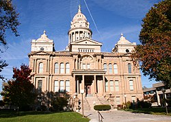
Troy-ohio-courthouse.jpg
County courthouse in Troy
Flag of Miami County, Ohio.png
MiamiCountyOhioSeal.png
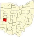
Map of Ohio highlighting Miami County.svg
Location within the U.S. state of Ohio
Ohio in United States.svg
Ohio's location within the U.S.
Coordinates: 40°03′N84°14′W / 40.05°N 84.23°W / 40.05; -84.23
CountryFlag of the United States.svg United States
StateFlag of Ohio.svg  Ohio
FoundedMarch 1, 1807 [1]
Named for Miami people
Seat Troy
Largest cityTroy*
Area
  Total
410 sq mi (1,100 km2)
  Land407 sq mi (1,050 km2)
  Water3.1 sq mi (8 km2)  0.8%
Population
 (2020)
  Total
108,774
  Density270/sq mi (100/km2)
Time zone UTC−5 (Eastern)
  Summer (DST) UTC−4 (EDT)
Congressional districts 8th, 15th
Website www.miamicountyohio.gov

Miami County is a county located in the U.S. state of Ohio. As of the 2020 census, the population was 108,774. [2] Its county seat is Troy. [3] The county is named in honor of the Miami people. [4] Miami County is part of the Dayton, OH Metropolitan Statistical Area.

Contents

Geography

According to the U.S. Census Bureau, the county has a total area of 410 square miles (1,100 km2), of which 407 square miles (1,050 km2) is land and 3.1 square miles (8.0 km2) (0.8%) is water. [5]

Adjacent counties

Demographics

Historical population
CensusPop.Note
1810 3,941
1820 8,851124.6%
1830 12,80744.7%
1840 19,68853.7%
1850 24,99927.0%
1860 29,95919.8%
1870 32,7409.3%
1880 36,15810.4%
1890 39,7549.9%
1900 43,1058.4%
1910 45,0474.5%
1920 48,4287.5%
1930 51,3015.9%
1940 52,6322.6%
1950 61,30916.5%
1960 72,90118.9%
1970 84,34215.7%
1980 90,3817.2%
1990 93,1823.1%
2000 98,8686.1%
2010 102,5063.7%
2020 108,7746.1%
U.S. Decennial Census [6]
1790-1960 [7] 1900-1990 [8]
1990-2000 [9] 2020 [2] >

2000 census

As of the census [10] of 2000, there were 98,868 people, 38,437 households, and 27,943 families living in the county. The population density was 243 people per square mile (94 people/km2). There were 40,554 housing units at an average density of 100 units per square mile (39/km2). The racial makeup of the county was 95.78% White, 1.95% Black or African American, 0.19% Native American, 0.79% Asian, 0.01% Pacific Islander, 0.28% from other races, and 1.00% from two or more races. 0.73% of the population were Hispanic or Latino of any race.

There were 38,437 households, out of which 33.30% had children under the age of 18 living with them, 59.50% were married couples living together, 9.70% had a female householder with no husband present, and 27.30% were non-families. 23.20% of all households were made up of individuals, and 9.50% had someone living alone who was 65 years of age or older. The average household size was 2.54 and the average family size was 2.99.

In the county, the population was spread out, with 25.90% under the age of 18, 7.60% from 18 to 24, 28.40% from 25 to 44, 24.80% from 45 to 64, and 13.20% who were 65 years of age or older. The median age was 38 years. For every 100 females there were 96.20 males. For every 100 females age 18 and over, there were 92.40 males.

The median income for a household in the county was $44,109, and the median income for a family was $51,169. Males had a median income of $37,357 versus $25,493 for females. The per capita income for the county was $21,669. About 5.10% of families and 6.70% of the population were below the poverty line, including 9.10% of those under age 18 and 5.60% of those age 65 or over.

2010 census

As of the 2010 United States Census, there were 102,506 people, 40,917 households, and 28,626 families living in the county. [11] The population density was 252.1 inhabitants per square mile (97.3/km2). There were 44,256 housing units at an average density of 108.8 units per square mile (42.0 units/km2). [12] The racial makeup of the county was 94.4% white, 2.0% black or African American, 1.2% Asian, 0.2% American Indian, 0.5% from other races, and 1.8% from two or more races. Those of Hispanic or Latino origin made up 1.3% of the population. [11] In terms of ancestry, 34.5% were German, 13.5% were Irish, 10.2% were English, and 9.8% were American. [13]

Of the 40,917 households, 32.3% had children under the age of 18 living with them, 54.7% were married couples living together, 10.5% had a female householder with no husband present, 30.0% were non-families, and 25.3% of all households were made up of individuals. The average household size was 2.48 and the average family size was 2.95. The median age was 40.6 years. [11]

The median income for a household in the county was $51,507 and the median income for a family was $61,190. Males had a median income of $46,133 versus $32,699 for females. The per capita income for the county was $25,006. About 7.0% of families and 9.5% of the population were below the poverty line, including 14.0% of those under age 18 and 4.8% of those age 65 or over. [14]

Politics

Miami County is a Republican stronghold county in presidential elections, with Democrats winning the county only three times in 1912, 1936, and 1964.

United States presidential election results for Miami County, Ohio [15]
Year Republican Democratic Third party(ies)
No.%No.%No.%
2024 42,67771.80%15,96926.87%7921.33%
2020 41,37171.23%15,66326.97%1,0431.80%
2016 37,07969.84%13,12024.71%2,8955.45%
2012 34,60666.53%16,38331.50%1,0251.97%
2008 33,41763.15%18,37234.72%1,1262.13%
2004 33,99265.67%17,60634.01%1620.31%
2000 26,03760.78%15,58436.38%1,2202.85%
1996 19,50948.77%15,54038.85%4,95612.39%
1992 19,74145.90%12,54729.17%10,71824.92%
1988 24,91568.38%11,13830.57%3811.05%
1984 26,30072.42%9,69526.70%3200.88%
1980 19,92855.65%12,89336.01%2,9878.34%
1976 18,68657.65%13,07440.34%6532.01%
1972 21,22668.44%9,12129.41%6652.14%
1968 16,99750.62%13,22839.40%3,3529.98%
1964 12,98540.12%19,37959.88%00.00%
1960 22,15165.30%11,77034.70%00.00%
1956 20,13568.57%9,22931.43%00.00%
1952 19,52565.11%10,46234.89%00.00%
1948 13,10056.33%10,06643.29%890.38%
1944 14,75158.47%10,47641.53%00.00%
1940 14,72555.52%11,79944.48%00.00%
1936 11,34344.86%12,75450.44%1,1894.70%
1932 12,15751.95%10,67745.62%5682.43%
1928 16,06372.80%5,86726.59%1360.62%
1924 11,85162.70%5,29628.02%1,7549.28%
1920 13,12260.28%8,07637.10%5722.63%
1916 5,77248.61%5,58247.01%5194.37%
1912 3,61532.49%4,31038.74%3,20028.76%
1908 6,55853.69%5,36943.95%2882.36%
1904 6,79362.44%3,64633.51%4404.04%
1900 6,19753.86%5,12744.56%1811.57%
1896 6,05152.60%5,38746.83%650.57%
1892 5,11051.26%4,27142.84%5885.90%
1888 5,31253.04%4,25842.51%4464.45%
1884 5,27355.56%4,08443.03%1341.41%
1880 4,92857.33%3,60441.93%640.74%
1876 4,38855.40%3,50944.31%230.29%
1872 3,75356.03%2,91043.45%350.52%
1868 3,95859.82%2,65940.18%00.00%
1864 3,82161.94%2,34838.06%00.00%
1860 3,43158.69%2,33739.98%781.33%
1856 3,17159.63%1,98837.38%1592.99%

Government

Current officials

Miami County Court of Common Pleas

Municipal Court

Education

Public school districts

Miscellaneous education

The Western Ohio Japanese Language School (オハイオ西部日本語学校 Ohaio Seibu Nihongo Gakkō) is a supplementary weekend Japanese school in unincorporated Miami County, near Troy. It started in April 1988. [17]

Communities

Municipalities and townships of Miami County Map of Miami County Ohio With Municipal and Township Labels.PNG
Municipalities and townships of Miami County

Cities

Villages

Townships

Unincorporated communities

See also

Related Research Articles

<span class="mw-page-title-main">Shelby County, Ohio</span> County in Ohio, United States

Shelby County is a county in the western portion of the U.S. state of Ohio. As of the 2020 United States Census, the population was 48,230. Its county seat is Sidney. Its name honors Isaac Shelby, first governor of Kentucky. Shelby County comprises the Sidney, OH Micropolitan Statistical Area, which is also included in the Dayton–Springfield–Sidney, OH Combined Statistical Area.

<span class="mw-page-title-main">Greene County, Ohio</span> County in Ohio, United States

Greene County is located in the southwestern portion of Ohio. As of the 2020 census, the population was 167,966. Its county seat is Xenia and its largest city is Beavercreek. The county was established on March 24, 1803 and named for General Nathanael Greene, an officer in the Revolutionary War. Greene County is part of the Dayton, OH Metropolitan Statistical Area.

<span class="mw-page-title-main">Clark County, Ohio</span> County in Ohio, United States

Clark County is a county located in the west central portion of the U.S. state of Ohio. As of the 2020 census, the population was 136,001. Its county seat and largest city is Springfield. The county was created on March 1, 1818, and was named for General George Rogers Clark, a hero of the American Revolution. Clark County comprises the Springfield, OH Metropolitan Statistical Area, which is also included in the Dayton-Springfield-Sidney-OH Combined Statistical Area.

<span class="mw-page-title-main">Buckland, Ohio</span> Village in Ohio, United States

Buckland is a village in Auglaize County, Ohio, United States. The population was 233 at the 2020 census. It is included in the Wapakoneta, Ohio Micropolitan Statistical Area. The village is served by the Wapakoneta City School District.

<span class="mw-page-title-main">St. Marys, Ohio</span> City in Ohio, United States

St. Marys is a city in Auglaize County, Ohio, United States. Located in western Ohio, it is 11 miles (18 km) west of Wapakoneta and 20 miles (32 km) east of the Ohio–Indiana border. Founded in 1823, the city is located on a portage between the St. Marys and Auglaize river systems, which was a significant factor in its development before the era of canals. The population was 8,397 at the 2020 census. It is included in the Wapakoneta micropolitan area.

<span class="mw-page-title-main">Uniopolis, Ohio</span> Unincorporated community and Census-designated place in Ohio, United States

Uniopolis is an unincorporated community and former village in Auglaize County, Ohio, United States. The population was 188 at the 2020 census. It is included in the Wapakoneta, Ohio Micropolitan Statistical Area.

<span class="mw-page-title-main">Waynesfield, Ohio</span> Village in Ohio, United States

Waynesfield is a village in Auglaize County, Ohio, United States. The population was 749 at the 2020 census. It is included in the Wapakoneta, Ohio Micropolitan Statistical Area.

<span class="mw-page-title-main">St. Paris, Ohio</span> Village in Ohio, United States

St. Paris or Saint Paris is a village in Champaign County, Ohio, United States. The population was 1,882 at the 2020 census.

<span class="mw-page-title-main">Park Layne, Ohio</span> Census-designated place in Ohio, United States

Park Layne is a census-designated place (CDP) in Bethel Township, Clark County, Ohio, United States. The population of the CDP was 4,248 at the 2020 census. It is part of the Springfield, Ohio Metropolitan Statistical Area. Park Layne became a CDP in the 1980 United States Census.

<span class="mw-page-title-main">Bethel, Ohio</span> Village in Ohio, United States

Bethel is a village in Tate Township, Clermont County, Ohio, United States. The population was 2,620 at the 2020 census.

<span class="mw-page-title-main">Grandview, Hamilton County, Ohio</span> Census-designated place in Ohio, United States

Grandview is a census-designated place (CDP) in Miami Township, Hamilton County, Ohio, United States. The population was 1,312 at the 2020 census.

<span class="mw-page-title-main">Covington, Ohio</span> Village in Ohio, United States

Covington is a village in Miami County, Ohio, United States. The population was 2,548 at the 2020 census. It is part of the Dayton Metropolitan Statistical Area. The village was incorporated as Covington in 1835 on the site of the 1793 Fort Rowdy.

<span class="mw-page-title-main">Laura, Ohio</span> Village in Ohio, United States

Laura is a village in Miami County, Ohio, United States. The population was 398 at the 2020 census. It is part of the Dayton Metropolitan Statistical Area.

<span class="mw-page-title-main">Piqua, Ohio</span> City in Ohio, United States

Piqua is a city in Miami County, Ohio, United States, along the Great Miami River. The population was 20,354 at the 2020 census. Located 27 miles (43 km) north of Dayton, it is part of the Dayton metropolitan area.

<span class="mw-page-title-main">Pleasant Hill, Ohio</span> Village in Ohio, United States

Pleasant Hill is a village in Miami County, Ohio, United States. The population was 1,241 at the 2020 census. It is part of the Dayton Metropolitan Statistical Area.

<span class="mw-page-title-main">Tipp City, Ohio</span> City in Ohio, United States

Tipp City is a city in southern Miami County, Ohio, United States, just outside Dayton. The population was 10,274 at the 2020 census. Originally known as Tippecanoe, and then Tippecanoe City, it was renamed to Tipp City in 1938 because another town in Ohio was likewise named Tippecanoe. The city lies in the Miami Valley and sits along Interstate 75 near the Interstate 70 interchange. Tipp City is part of the Dayton metropolitan area.

<span class="mw-page-title-main">Troy, Ohio</span> City and county seat of Miami County, Ohio

Troy is a city in and the county seat of Miami County, Ohio, United States, along the Great Miami River. The population was 26,305 at the 2020 census, making it Miami County's largest city and Ohio's 55th-largest. About 19 miles (31 km) north of Dayton, Troy is part of the Dayton metropolitan area.

<span class="mw-page-title-main">Bradford, Ohio</span> Village in Ohio, United States

Bradford is a village in Darke and Miami counties in the U.S. state of Ohio. The population was 1,796 at the 2020 census.

<span class="mw-page-title-main">Union, Ohio</span> City in Ohio, United States

Union is a city in Montgomery and Miami Counties in the U.S. state of Ohio. The population was 6,859 at the time of the 2020 census. It is part of the Dayton Metropolitan Statistical Area.

<span class="mw-page-title-main">West Milton, Ohio</span> Village in Ohio, United States

West Milton is a village in Miami County, Ohio, United States. The population was 4,697 at the 2020 census. It is part of the Dayton Metropolitan Statistical Area.

References

  1. "Ohio County Profiles: Miami County" (PDF). Ohio Department of Development. Archived from the original (PDF) on June 21, 2007. Retrieved April 28, 2007.
  2. 1 2 2020 census
  3. "Find a County". National Association of Counties. Archived from the original on May 31, 2011. Retrieved June 7, 2011.
  4. "Miami County". Ohio History Central. Retrieved March 18, 2020.
  5. "2010 Census Gazetteer Files". United States Census Bureau. August 22, 2012. Archived from the original on May 4, 2014. Retrieved February 9, 2015.
  6. "U.S. Decennial Census". United States Census Bureau. Retrieved February 9, 2015.
  7. "Historical Census Browser". University of Virginia Library. Retrieved February 9, 2015.
  8. Forstall, Richard L., ed. (March 27, 1995). "Population of Counties by Decennial Census: 1900 to 1990". United States Census Bureau. Retrieved February 9, 2015.
  9. "Census 2000 PHC-T-4. Ranking Tables for Counties: 1990 and 2000" (PDF). United States Census Bureau. April 2, 2001. Archived (PDF) from the original on March 27, 2010. Retrieved February 9, 2015.
  10. "U.S. Census website". United States Census Bureau . Retrieved January 31, 2008.
  11. 1 2 3 "DP-1 Profile of General Population and Housing Characteristics: 2010 Demographic Profile Data". United States Census Bureau. Archived from the original on February 13, 2020. Retrieved December 27, 2015.
  12. "Population, Housing Units, Area, and Density: 2010 - County". United States Census Bureau. Archived from the original on February 13, 2020. Retrieved December 27, 2015.
  13. "DP02 Selected Social Characteristics in the United States – 2006-2010 American Community Survey 5-Year Estimates". United States Census Bureau. Archived from the original on February 13, 2020. Retrieved December 27, 2015.
  14. "DP03 Selected Economic Characteristics – 2006-2010 American Community Survey 5-Year Estimates". United States Census Bureau. Archived from the original on February 13, 2020. Retrieved December 27, 2015.
  15. Leip, David. "Dave Leip's Atlas of U.S. Presidential Elections". uselectionatlas.org. Retrieved April 7, 2018.
  16. https://www.daytondailynews.com/local/miami-county-recorder-lopez-resigns-odd-november-election-to-decide-replacement/SNZAFNEBZNAYFKL76JWIANTDXQ/
  17. "本校概要" (Archive). Western Ohio Japanese Language School. Retrieved on May 11, 2014.

, 40°03′N84°14′W / 40.05°N 84.23°W / 40.05; -84.23