Pandan Gardens

Last updated

Pandan Gardens
housing estate
Name transcription(s)
   Chinese 班丹花园
   Pinyin ban1 dan1 hua1 yuan2
   Malay Taman Pandan
   Tamil பாண்டான் கார்டன்ஸ்
Singapore location map (main island).svg
Red pog.svg
Pandan Gardens
Location of Pandan Gardens within Singapore
Coordinates: Coordinates: 01°19′13.59″N103°44′51.86″E / 1.3204417°N 103.7477389°E / 1.3204417; 103.7477389
Country Singapore

Pandan Gardens is a housing estate which is part of Jurong East New Town in the West Region of Singapore. Immediately north of Pandan Reservoir and adjacent to Teban Gardens, it comprises exclusively public housing built by the JTC Corporation and Housing and Development Board. Its namesake road connects Jurong Town Hall Road to West Coast Road.

Contents

Geography

Like its sister town – Teban Gardens, Pandan Gardens was a patch of mangrove swamp bordering on the banks of Sungai Pandan [1] but was subsequently reclaimed to make way for housing development projects by the JTC Corporation in 1970. [1]

Flanked on the south side by the Pandan Reservoir and the east side by the bank of Sungai Pandan, it sits situated at the fringe of Jurong Industrial Estate as well as being on the crossroad from Singapore's city center and other parts of the island towards the various industrial estates located within Jurong, Tuas and the nearby Jurong Island.

History

The name was derived from the former Malay village in the area, Kampong Sungei Pandan. Although the land reclamation of the estate began in 1970, [1] the actual construction did not commence until after 1975 as the land needed time to settle after being reclaimed from the mangrove swampland of the Sungai Pandan. JTC Corporation undertook the construction of the public housing blocks in the estate as a means to provide additional housings for the families of the workers from the nearby areas of Jurong Industrial Estate. This was done to help ease the housing problem due in part by the overcrowding in the then nearby Taman Jurong housing estate, which was also built by JTC in 1969. [2]

The first housing block was completed around 1978 [1] with a running sequence from block No.401 through to 416 (both 415 and 416 are four-storey shophouses). Currently, Pandan Gardens and Teban Gardens are satellite towns to the nearby Jurong East New Town.

Amenities

Although Pandan has a few shophouses of its own at block No. 415 and 416, it lacks a wet market like the one found in Teban Gardens, [3] hence it gets to share the service of the market with the residents of Teban Gardens. Also located in Teban Gardens is the Ayer Rajah Neighbourhood Police Post (NPP) of Clementi Police Division [4] at block No.43, which continues to serve the residents since its inauguration in 1985.

For entertainment and shopping, there was the nearby Jurong Entertainment Centre which has been replaced with JCube, managed by CapitaMalls Asia & IMM Shopping Mall. Nearby the two shopping centres, there is also the Jurong Regional Library which is a regional public library serving the needs of all the residents and students in the surrounding region, including Pandan Gardens.

In year 2014 & early 2015 respectively, there will be a new hospital, locating right in front of the IMM Shopping Mall, and that is, Ng Teng Fong Hospital (previously Jurong General Hospital), managed by Jurong Health.

In January 2013, the old Pandan Gardens Swimming Complex was re-opened as Playlor! Arena, which is a multi-sports complex. It features 2 astroturf courts for futsal use, 1 multipurpose court, and 1 indoor beach court.

Public transport

Pandan Gardens is accessible via public transport service by taking Bus services 51 or 143 to the Jurong East MRT station and the Jurong East Bus Interchange, while Ayer Rajah Expressway provides it with a well connected road access.

SBS Transit Service 143 SBS9483Gfront.JPG
SBS Transit Service 143
Nearest MRT station
Jurong East MRT station (1988 – present)
Nearest bus interchange
Jurong Bus Depot / Interchange (now defunct, 1978 – 1991)
Jurong East Bus Interchange (1988 – present)
Bus services serving the town
SBS Transit service number: 30, 51, 154, 197, 198, 201, 655
SMRT Buses service number: 176
Tower Transit Singapore service number: 78, 79, 143, 143M
City Transit service number: 762

Public schools

Politics

West Coast Group Representation Constituency. West Coast GRC locator map.svg
West Coast Group Representation Constituency.

As of May 2020, Pandan Gardens is a part of Ayer Rajah ward within the West Coast GRC. [5]

Together with Teban Gardens, parts of Jurong East New Town and Clementi West New Town, the four estates formed the Single Member Constituency (SMC) [6] of Ayer Rajah SMC prior to being absorbed into the West Coast Group Representation Constituency during the 2006's election in Singapore. Dr Tan Cheng Bock was the incumbent member of Parliament, since the formation of the ward in 1980. Dr Tan subsequently retired in 2006 after making way for his successor – Mr S Iswaran. After the 2011 Singaporean general election, the Members of Parliament (MPs) within the constituency was reshuffled and Mr Iswaran was reassigned to become the MP for West Coast, while Ms Foo Mee Har took over as MP for Ayer Rajah (Now Ayer Rajah - Gek Poh).

See also

Related Research Articles

<span class="mw-page-title-main">Jurong</span> Commercial district and Regional centre in West Region, Singapore

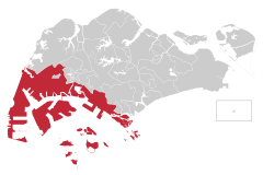
Jurong is a major geographical region located at the south-westernmost point of the West Region of Singapore. Although mostly vaguely defined, the region's extent roughly covers the planning areas of Jurong East, Jurong West, Boon Lay, and Pioneer, along with Jurong Island in the Western Islands cluster and the southernmost portions of the Western Water Catchment. Should it be described at its greatest historical extent, the region can also include present-day Bukit Batok and Tuas.

<span class="mw-page-title-main">Woodlands, Singapore</span> Planning Area and Regional Centre in North Region, Singapore

Woodlands is a planning area and residential town located in the North of Singapore. As of 2019, the town has a population of 254,733. It is the densest planning area and is the regional centre for the North Region of the country.

<span class="mw-page-title-main">Clementi, Singapore</span> Planning Area and HDB Town in West Region, Singapore

Clementi is a planning area and residential town located at the easternmost fringe of the West Region of Singapore. The town borders Bukit Batok to the north, Bukit Timah to the northeast, Queenstown to the east and Jurong East to the west.

<span class="mw-page-title-main">Bedok</span> Planning Area and HDB Town in East Region ----, Singapore

Bedok is a planning area and matured residential town located in the geographical region of Tanah Merah along the south-eastern coast of the East Region of Singapore. Bedok is bounded by five other planning areas: Paya Lebar to the north, Hougang to the northwest, Tampines to the northeast and east, Geylang to the west and Marine Parade to the southwest. It also shares a maritime boundary with the Singapore Strait to the south and southeast.

<span class="mw-page-title-main">Bukit Merah</span> Planning Area and HDB Town in Central Region ----, Singapore

Bukit Merah, also known as Redhill, is a planning area and new town situated in the southernmost part of the Central Region of Singapore. the planning area borders Tanglin to the north, Queenstown to the west and the Downtown Core, Outram and Singapore River planning areas of the Central Area to the east.

<span class="mw-page-title-main">Jurong East</span> Planning Area and Regional Centre in West Region, Singapore

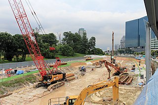
Jurong East is a planning area and residential town situated in the West Region of Singapore. It borders Jurong West and Boon Lay to the west, Clementi to the east, Tengah and Bukit Batok to the north and Selat Jurong to the south.

<span class="mw-page-title-main">Jurong West</span> Planning Area and HDB Town in West Region ----, Singapore

Jurong West is a planning area and residential town located in the West Region of Singapore. Jurong West shares boundaries with Tengah in the north, Jurong East in the east, Boon Lay and Pioneer in the south, and Western Water Catchment in the west.

Jurong East Bus Interchange is a bus interchange located in Jurong East, Singapore. An open-air single-level bus terminal, it is connected to the adjacent Jurong East MRT station via a link bridge.

Taman Jurong is a residential precinct in Jurong West, Singapore. It is one of the oldest residential precincts in Singapore and a division of Jurong GRC, with the area's HDB flats under the management of Jurong-Clementi Town Council and Tharman Shanmugaratnam as the area's MP.

Teban Gardens is a residential precinct located in Jurong East, Singapore. Immediately north of Pandan Reservoir, it comprises exclusively public housing built by the JTC Corporation and Housing and Development Board.

<span class="mw-page-title-main">West Coast, Singapore</span> Subzone of Clementi Planning Area in Singapore

West Coast is a subzone located in the town of Clementi, the western part of Singapore. The subzone currently lies in the West Coast GRC.

Ayer Rajah Single Member Constituency (SMC) was a single member constituency in Singapore that existed from 1980 to 2006.

Wenya is a subzone of Jurong West, Singapore.

Bukit Timah Single Member Constituency(SMC) was a single member constituency in Bukit Timah, Singapore. It was formerly known as Bukit Timah Constituency before 1988.

Yuhua is a subzone region located in the town of Jurong East, Singapore. Yuhua comprises two subzones, Yuhua East and Yuhua West. The area's HDB flats are under the management of Jurong-Clementi Town Council and the people of this precinct are represented in parliament by either Grace Fu or Rahayu Mahzam, depending on where they stay.

<span class="mw-page-title-main">Jurong Town Hall Road</span> Road in Jurong East, Singapore

Jurong Town Hall Road is a road in Jurong East, Singapore that connects the Pan Island Expressway and West Coast Road.

<span class="mw-page-title-main">Jurong Town Hall MRT station</span> Future MRT station in Singapore

Jurong Town Hall MRT station is a future elevated Mass Rapid Transit (MRT) station on the Jurong Region Line in Jurong East, Singapore.

<span class="mw-page-title-main">Pandan Reservoir MRT station</span> Future MRT station in Singapore

Pandan Reservoir MRT station is a future elevated Mass Rapid Transit (MRT) station on the Jurong Region line in Jurong East, Singapore.

References

  1. 1 2 3 4 "BALLOTING OF JTC 5-ROOM FLATS AT PANDAN GARDENS". National Archives of Singapore (Jurong Town Corporation - Press Release). 19 August 1978. Retrieved 27 March 2016.
  2. "Ministry of Health, Singapore Press Release" (PDF). National Archive of Singapore. Archived from the original (PDF) on 11 June 2011.
  3. "Map of Teban Garden Market & Food Center". sg.shownearby.com.[ permanent dead link ]
  4. "Singapore Police Force Internet Portal". Singapore Police Force. Archived from the original on 18 March 2008. Retrieved 12 March 2008.
  5. "MPs of West Coast GRC". West Coast Town Council. Archived from the original on 20 March 2008.
  6. "Types of Electoral Divisions, SMC & GRC". Elections Department, Singapore.