Related Research Articles

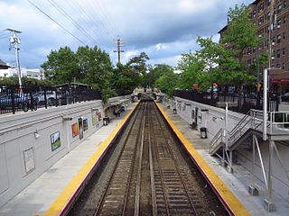
The Laurelton station is a station on the Long Island Rail Road's Atlantic Branch, in the Laurelton neighborhood of Queens, New York City. It is 14.9 miles (24.0 km) from Penn Station in Midtown Manhattan. The station is located at the intersection of 225th Street and 141st Road.

Douglaston is a station on the Long Island Rail Road's Port Washington Branch in the Douglaston neighborhood of Queens, New York City. The station is at 235th Street and 41st Avenue, off Douglaston Parkway and Wainscott Avenue, and is 13.9 miles (22.4 km) from Penn Station in Midtown Manhattan. The station is part of CityTicket, and has an underground walkway between the two platforms.
Great Neck is a station on the Long Island Rail Road's Port Washington Branch in Great Neck Plaza, New York. It is the westernmost station on the branch in Nassau County. The station is located at Middle Neck Road and Station Plaza at Great Neck Road, 0.25 miles (0.40 km) north of Northern Boulevard and 15.9 miles (25.6 km) from Penn Station in Midtown Manhattan. From just east of the station, the line becomes single track to Port Washington.

Lawrence is a station on the Long Island Rail Road's Far Rockaway Branch in Lawrence, in Nassau County, New York, United States. The station is officially located at Lawrence Avenue and Bayview Avenue, two blocks west of Central Avenue. However, the actual location is two blocks north of Central Avenue, and Bayview Avenue is on the opposite side of the tracks. Lawrence Station is 21.8 miles (35.1 km) from Penn Station in Midtown Manhattan.

The Port Jefferson Branch is a rail line and service owned and operated by the Long Island Rail Road in the U.S. state of New York. The branch splits from the Main Line just east of Hicksville and runs northeast and east to Port Jefferson. Several stations on the Main Line west of Hicksville are served primarily by trains bound to/from the Port Jefferson branch, so LIRR maps and schedules for the public include that part of the Main Line in the "Port Jefferson Branch" service.

Lynbrook is a Long Island Rail Road commuter train station in Lynbrook, New York. The station is located at the intersection of Sunrise Highway and Peninsula Boulevard and is located on the railroad's Montauk Branch and Long Beach Branch lines and is served by Long Beach Branch trains and select weekday Babylon Branch trains. The station is elevated and is wheelchair accessible through elevator access.

Westwood is a station on the Long Island Rail Road's West Hempstead Branch serving the villages of Malverne and Lynbrook, New York. The station platform is located on Foster Avenue in Malverne, with parking facilities on both the Malverne and Lynbrook sides of the tracks. It has no station building other than a pair of open shelters, the larger one on the Malverne side of the tracks. It also features a gated at-grade pedestrian crossing, one of only a few stations on the Long Island Rail Road to feature such crossings.

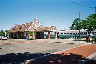
Huntington is a station on the Port Jefferson Branch of the Long Island Rail Road. It is located near New York Avenue, connecting it to Melville, the Long Island Expressway and Huntington and Broadway in Huntington Station, New York.

Sayville is a station on the Montauk Branch of the Long Island Rail Road in the village of Sayville, New York, on Depot Street between Greeley Avenue and Railroad Avenue. Ferries to Fire Island board from a port south of the station.
Riverhead is a station along the Main Line of the Long Island Rail Road. It is located on Osborne Avenue and Railroad Street in Riverhead, New York, north of NY 25 and the Suffolk County Court House.

Oyster Bay is the terminus on the Oyster Bay Branch of the Long Island Rail Road. The station is located off Shore Avenue between Maxwell and Larabee Avenues. It is a sheltered concrete elevated platform that stands in the shadows of the original station, which was accessible from the ends of Maxwell, Audrey, and Hamilton Avenues. Both stations exist along the south side of Roosevelt Park.

Brentwood is a station on the Main Line of the Long Island Rail Road. It is officially located at Suffolk County Road 100 and Brentwood Road in Brentwood, New York. However, it has parking facilities and other amenities that are extended far beyond its given location. The actual station is located across the tracks from the dead end of Eighth Street near Leroy Avenue. The parking lot entrance is on Suffolk Avenue 1⁄2 mile (0.80 km) east of Brentwood Road/Washington Avenue.

Greenlawn is a station on the Port Jefferson Branch of the Long Island Rail Road near the intersection of Boulevard Avenue and Broadway in Greenlawn, New York, a few blocks north of Pulaski Road. It is the first station east of Huntington on the non-electrified section of the branch.

Bethpage is a station along the Main Line of the Long Island Rail Road. It is located at Stewart Avenue and Jackson Avenue, in Bethpage, New York, and serves Ronkonkoma Branch trains. Trains that travel along the Central Branch also use these tracks, but none stop here.

Bellport is a station along the Montauk Branch of the Long Island Rail Road, at Bellport Station Road and Montauk Highway in North Bellport, New York.

Mattituck is a station on the Main Line of the Long Island Rail Road. It is located on Love Lane and Pike Street, north of New York State Route 25 in Mattituck, New York.
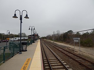
Westhampton is a station along the Montauk Branch of the Long Island Rail Road. It is on Station Road and Depot Road in Westhampton, New York, just west of Old Riverhead Road and south of the Francis S. Gabreski Airport.

Bellerose is a station along the Main Line and Hempstead Branch of the Long Island Rail Road (LIRR). The station is at Commonwealth Boulevard and Superior Road, 0.25 miles (0.40 km) south of Jericho Turnpike, in Bellerose, New York and has a full-service ticket machine on the north side of the station, next to the underpass entrance and a daily machine on the south side next to the underpass entrance.

The Rockville Centre station is a station along the Babylon Branch of the Long Island Rail Road. It is officially at North Village Avenue and Front Street north of Sunrise Highway in Rockville Centre, New York, but the station property spreads west to North Center Avenue and east to North Park Avenue. Parking is available throughout the Village of Rockville Centre, near the station for those with residential and non-residential permits. The station is east of the former Rockville Centre Bus Depot. The station is 21.1 miles (34.0 km) from Penn Station.
Bartlett's was a private flag stop on the Long Island Rail Road's Main Line, that opened under the name Bellport in 1844 with the opening of the LIRR. Located 2+1⁄2 miles (4.0 km) east of Medford station and thus much further north than Bellport, it included a stagecoach connection down Bellport (Station) Road to Bellport Village, hence the station's name.
References
- 1 2 3 "BROOKLYN & JAMAICA RAIL ROAD, LONG ISLAND R. R. 1852 TIMETABLE". arrts-arrchives.com.
- ↑ "EARLY TROUBLES OF THE LIRR". 1949-06-09. Archived from the original on 2015-06-21. Retrieved 2023-11-27.
- ↑ "Annual Report of the American Institute, on the Subject of Agriculture". google.com. 1848.
- ↑ "Annual Report of the American Institute of the City of New York". google.com. 1848.
- ↑ Fisher, Richard Swainson (1851). "American Railway Guide, and Pocket Companion, for the United States". google.com.
- ↑ Fisher, Richard Swainson (1855). "A New and Complete Statistical Gazetteer of the United States of America". google.com.
- ↑ Mitchell's New Traveller's Guide: Through the United States and the Canadas … By Samuel Augustus Mitchell