Montauk Highway is an east–west road extending for 95 miles (153 km) across the southern shore of Long Island in Suffolk County, New York, in the United States. It extends from the Nassau County line in Amityville, where it connects to Merrick Road, to Montauk Point State Park at the very eastern end of Long Island in Montauk. The highway is known by several designations along its routing, primarily New York State Route 27A (NY 27A) from the county line to Oakdale and NY 27 east of Southampton. The portion of Montauk Highway between Oakdale and Southampton is mostly county-maintained as County Route 80 and County Route 85.

New York State Route 27 (NY 27) is a 120.58-mile (194.05 km) long state highway that runs east–west from Interstate 278 (I-278) in the New York City borough of Brooklyn to Montauk Point State Park on Long Island, New York. Its two most prominent components are Sunrise Highway and Montauk Highway, the latter of which includes the Montauk Point State Parkway. NY 27 acts as the primary east–west highway on southern Long Island east of the interchange with the Heckscher State Parkway in Islip Terrace. The entire route in Suffolk, Nassau, and Queens counties were designated by the New York State Senate as the POW/MIA Memorial Highway. The highway gives access to every town on the South Shore. NY 27 is the easternmost state route in the state of New York.

The Montauk Branch is a rail line owned and operated by the Long Island Rail Road in the U.S. state of New York. The line runs the length of Long Island, 115 miles (185 km) from Long Island City to Montauk. However, in LIRR maps and schedules for public use, the term Montauk Branch refers to the line east of Babylon; service from Jamaica to Babylon is covered by separate Babylon Branch schedules, while the line west of Jamaica is currently unused for passenger service. A select number of Montauk Branch trains operate via the Main Line during peak hours.

New York State Route 27A (NY 27A) is a state highway extending from Massapequa in Nassau County to Oakdale in Suffolk County on Long Island, New York, in the United States. Its two most prominent components are Merrick Road and Montauk Highway.

Lynbrook is a Long Island Rail Road commuter train station in Lynbrook, New York. The station is located at the intersection of Sunrise Highway and Peninsula Boulevard and is located on the railroad's Montauk Branch and Long Beach Branch lines and is served by Long Beach Branch trains and select weekday Babylon Branch trains. The station is elevated and is wheelchair accessible through elevator access.
The Sag Harbor Branch was a branch of the Long Island Rail Road that was the eastern terminal on the south shore line of Long Island from 1869 to 1895 and then was a spur from Bridgehampton to Sag Harbor, New York from 1895 to 1939.
The Long Island Rail Road is a railroad owned by the Metropolitan Transportation Authority in the U.S. state of New York. It is the oldest United States railroad still operating under its original name and charter. It consolidated several other companies in the late 19th century. The Pennsylvania Railroad owned the Long Island Rail Road for the majority of the 20th century and sold it to the State in 1966.

Dunton was a ground-level station on the Long Island Rail Road's Montauk Branch, Atlantic Branch, and later the Main Line in Dunton, Queens, New York City, United States. It was closed in 1939 when the Atlantic Branch was placed in a tunnel east of East New York.

Rockaway Junction was a junction and station on the Long Island Rail Road's Main Line and Montauk Branch in Hillside, Queens, New York City, United States. It was located in the vicinity where the Montauk Branch now crosses over the two eastbound passenger tracks and the two freight tracks of the Main Line, just west of the Hillside Facility, although at the time of the station's existence it was at ground level along with the junction itself.
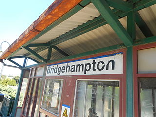
Bridgehampton is a station along the Montauk Branch of the Long Island Rail Road. It is located at Maple Lane and Butter Lane, in Bridgehampton, New York.

Bellport is a station along the Montauk Branch of the Long Island Rail Road, at Bellport Station Road and Montauk Highway in North Bellport, New York.

Amagansett is a station on the Montauk Branch of the Long Island Rail Road, at Main Street (NY 27) and Abrahms Landing Road in Amagansett, New York.
Wainscott was a former railroad station on the Montauk Branch of the Long Island Rail Road in Wainscott, New York, United States. It was opened in either 1897 or 1898 by the Brooklyn and Montauk Railroad, rebuilt in 1915 by the LIRR, and closed in 1938.

Manorville was a railroad station on the Main Line of the Long Island Rail Road in Manorville, New York. The station was built in 1844 and closed in 1968.

Eastport was a railroad station built on the former Manorville Branch of the Long Island Rail Road in Eastport, New York. It was opened in 1870 and closed in 1958. It was the easternmost station along both branches in the Town of Brookhaven.
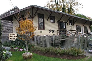
Sag Harbor was the terminus of the abandoned Sag Harbor Branch of the Long Island Rail Road, and was one of two stations within the village of Sag Harbor, New York. It opened in 1870 with the arrival of the LIRR into Sag Harbor, and was the eastern terminus of the LIRR on the south fork of Long Island until 1895, when the Brooklyn and Montauk Railroad built a line from Bridgehampton to Montauk, thus converting the line into a spur north of Bridgehampton. Besides the standard passenger station, it also contained a freight house, and "express building," two yards, a spur to "Long Wharf" which was owned by the LIRR affiliated Montauk Steamboat Company, a coal trestle, a turntable, and a three-story grain storage building owned by The station was rebuilt in 1909 in a manner similar to such stations as Riverhead, Bay Shore, Manhasset, and Bayside stations, among others. During World War I, it was used to transport torpedoes to Long Wharf in order to test them. It was abandoned in 1939 along with the branch. Today, Long Wharf is Suffolk County Road 81, and the former freight house became the Sag Harbor Garden Center's retail store until February 1, 2022, when renovations began to transform to building into Kidd Squid Brewing Company's flagship tasting room, which opened in July 2022 and continues in operation today.
