Cold Spring Harbor station

Last updated

Cold Spring Harbor
Cold Spring Harbor station.jpg
Cold Spring Harbor station
General information
Location West Pulaski Road & East Gate Drive
West Hills, New York
Coordinates 40°50′06″N73°27′06″W / 40.835056°N 73.451611°W / 40.835056; -73.451611
Owned by Long Island Rail Road
Platforms2 side platforms
Tracks2
Connections NYS Bike Route 25A [1]
Construction
ParkingYes; Town of Huntington residential permits
Bicycle facilitiesYes; Bike Racks and Lockers
AccessiblePartially ADA-accessible (Platform A)
Other information
Fare zone9
History
Opened1901 or 1902
Rebuilt1948
ElectrifiedOctober 19, 1970 [2]
750 V (DC) third rail
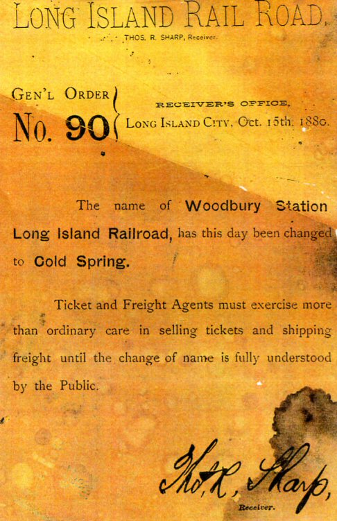
Previous namesWoodbury (18751880)
Passengers
20064,166 [3]
Services
Preceding station MTA NYC logo.svg Long Island Rail Road Following station
Syosset Port Jefferson Branch Huntington
Former services
Preceding station Long Island
Rail Road
Following station
Syosset
toward Hicksville
Wading River Branch Huntington
toward Wading River

Cold Spring Harbor is a station on the Long Island Rail Road's Port Jefferson Branch. It is located at West Pulaski Road and East Gate Drive, just south of Woodbury Road in West Hills, Suffolk County, New York.

Contents

History

The westbound platform, with the station house visible at center-right. CSH LIRR newsstand closed jeh.jpg
The westbound platform, with the station house visible at center-right.

A station was built in Nassau (then Queens) County in December 1875 in nearby Woodbury as "Woodbury station", as an extension of the Hicksville and Syosset Railroad. It was renamed "Cold Spring station" on October 15, 1880, [4] [5] when the southern part of Laurel Hollow was still known as Cold Spring. Sometime between 1901 and 1902, the station was moved east to the now Cold Springs Hills community of the hamlet of West Hills and took its current name of Cold Spring Harbor. [4] The station was reconstructed in 1948, during which time the current station house was erected. [4] [6] In 1970, the station was electrified, along with the rest of the Port Jefferson Branch between Mineola and Huntington. [7]

Since 2007, the station has served as the western terminus of New York State Bicycle Route 25A. [8]

Station layout

The station has two high-level side platforms. Platform A is 12 cars long and Platform B is eight cars long. One inbound morning train and three outbound evening trains stop at the opposite platform.

MMezzanineCrossover between platforms
P
Platform level
Ground levelEntrance/exit, parking, buses
Platform A, side platform Wheelchair symbol.svg
Track 1      Port Jefferson Branch toward Grand Central Madison, Long Island City, or Penn Station (Syosset)
Track 2      Port Jefferson Branch toward Huntington or Port Jefferson (Huntington)
Platform B, side platform

Related Research Articles

<span class="mw-page-title-main">Copiague station</span> Long Island Rail Road station in Suffolk County, New York

Copiague is a station on the Babylon Branch of the Long Island Rail Road, located in Copiague, New York. The station is located on Marconi Boulevard and Great Neck Road, one block north of Oak Street.

<span class="mw-page-title-main">Port Jefferson Branch</span> Long Island Rail Road branch

The Port Jefferson Branch is a rail line and service owned and operated by the Long Island Rail Road in the U.S. state of New York. The branch splits from the Main Line just east of Hicksville and runs northeast and east to Port Jefferson. Several stations on the Main Line west of Hicksville are served primarily by trains bound to/from the Port Jefferson branch, so LIRR maps and schedules for the public include that part of the Main Line in the "Port Jefferson Branch" service.

<span class="mw-page-title-main">Hicksville station</span> Long Island Rail Road station in Nassau County, New York

The Hicksville station is a station on the Main Line and Port Jefferson Branch of the Long Island Rail Road located in Hicksville, New York. It is the busiest station east of Jamaica and Penn Station by combined weekday/weekend ridership.

<span class="mw-page-title-main">Montauk Branch</span> Long Island Rail Road branch

The Montauk Branch is a rail line owned and operated by the Long Island Rail Road in the U.S. state of New York. The line runs the length of Long Island, 115 miles (185 km) from Long Island City to Montauk. However, in LIRR maps and schedules for public use, the term Montauk Branch refers to the line east of Babylon; service from Jamaica to Babylon is covered by separate Babylon Branch schedules, while the line west of Jamaica is currently unused for passenger service. A select number of Montauk Branch trains operate via the Main Line during peak hours.

<span class="mw-page-title-main">Ronkonkoma Branch</span> Long Island Rail Road branch

The Ronkonkoma Branch is a rail service operated by the Long Island Rail Road (LIRR) in the U.S. state of New York. On LIRR maps and printed schedules, the "Ronkonkoma Branch" includes trains running along the railroad's Main Line from Hicksville to Ronkonkoma, and between Ronkonkoma and the Main Line's eastern terminus at Greenport. The section of the Main Line east of Ronkonkoma is not electrified and is referred to as the Greenport Branch.

<span class="mw-page-title-main">Westbury station (LIRR)</span> Long Island Rail Road station in Nassau County, New York

Westbury is a station on the Long Island Rail Road's Main Line. All trains for the Port Jefferson Branch and Ronkonkoma Branch run through it, though only some trains on the Port Jefferson branch stop. It is located at Union and Post Avenues in Westbury, New York. It is 23.4 miles (37.7 km) from Penn Station. The station is fully wheelchair accessible. It has two side platforms and three tracks.

<span class="mw-page-title-main">Main Line (Long Island Rail Road)</span> Long Island Rail Road branch

The Main Line is a rail line owned and operated by the Long Island Rail Road in the U.S. state of New York. It begins as a two-track line at Long Island City station in Long Island City, Queens, and runs along the middle of Long Island about 95 miles (153 km) to Greenport station in Greenport, Suffolk County. At Harold Interlocking approximately one mile east of Long Island City, the tracks from the East River Tunnels and 63rd Street Tunnel into Manhattan intersect with the Main Line, which most trains use rather than using the Long Island City station.

<span class="mw-page-title-main">Stony Brook station (LIRR)</span> Long Island Rail Road station in Suffolk County, New York

Stony Brook is a historic station on the Port Jefferson Branch of the Long Island Rail Road. It is located in Stony Brook, New York, adjacent to the campus of Stony Brook University, on the southeast side of New York State Route 25A, across the street from the its intersection with Cedar Street. There is also a gated at-grade pedestrian crossing between the station and a parking lot at the University – one of only a few stations on the Long Island Rail Road to feature such crossings.

<span class="mw-page-title-main">Smithtown station</span> Long Island Rail Road station in Suffolk County, New York

Smithtown is a station on the Port Jefferson Branch of the Long Island Rail Road. It is located off a low bridge over NY 25 – 25A along Redwood Lane between NY 25 – 25A and Landing Avenue in Smithtown, New York.

<span class="mw-page-title-main">St. James station (LIRR)</span> Long Island Rail Road station in Suffolk County, New York

St. James is a station and historic landmark on the Port Jefferson Branch of the Long Island Rail Road. The station is located on Lake Avenue and Railroad Avenue, just south of New York State Route 25A in St. James, Suffolk County, New York.

The Long Island Rail Road is a railroad owned by the Metropolitan Transportation Authority in the U.S. state of New York. It is the oldest United States railroad still operating under its original name and charter. It consolidated several other companies in the late 19th century. The Pennsylvania Railroad owned the Long Island Rail Road for the majority of the 20th century and sold it to the State in 1966.

<span class="mw-page-title-main">Kings Park station (LIRR)</span> Long Island Rail Road station in Suffolk County, New York

Kings Park is a station on the Port Jefferson Branch of the Long Island Rail Road. It is located at the southwest corner of Suffolk CR 14 and NY 25A in Kings Park, New York.

<span class="mw-page-title-main">County Route 11 (Suffolk County, New York)</span> County road in Suffolk County, New York, US

County Route 11 (CR 11), mostly known as Pulaski Road, is a county road in northwestern Suffolk County, New York, in the United States. It runs west to east between New York State Route 108 in Cold Spring Harbor and New York State Route 25A in Kings Park. Most of the road is two lanes wide, although there are some areas where it opens up to four lanes, or simply allows center-left-turn lanes.

<span class="mw-page-title-main">Syosset station</span> Long Island Rail Road station in Nassau County, New York

Syosset is a station on the Long Island Rail Road's Port Jefferson Branch in Syosset, New York. It is located at Jackson Avenue and Underhill Boulevard, south of New York State Route 25A, but north of Jericho Turnpike and the Long Island Expressway. Syosset's downtown was built around the station. There are no public transportation connections at the station, but taxi service is available.

<span class="mw-page-title-main">Greenlawn station</span> Long Island Rail Road station in Suffolk County, New York

Greenlawn is a station on the Port Jefferson Branch of the Long Island Rail Road near the intersection of Boulevard Avenue and Broadway in Greenlawn, New York, a few blocks north of Pulaski Road. It is the first station east of Huntington on the non-electrified section of the branch.

<span class="mw-page-title-main">Bethpage station</span> Long Island Rail Road station in Nassau County, New York

Bethpage is a station along the Main Line of the Long Island Rail Road. It is located at Stewart Avenue and Jackson Avenue, in Bethpage, New York, and serves Ronkonkoma Branch trains. Trains that travel along the Central Branch also use these tracks, but do not stop here.

<span class="mw-page-title-main">East Williston station</span> Long Island Rail Road station in Nassau County, New York

East Williston is the first station along the Oyster Bay Branch of the Long Island Rail Road, located at Hillside Avenue and Pennsylvania Avenue on the border between the Incorporated Villages of East Williston and Williston Park, in Nassau County, New York.

<span class="mw-page-title-main">Carle Place station</span> Long Island Rail Road station in Nassau County, New York

Carle Place is a station along the Main Line of the Long Island Rail Road (LIRR). It is served by trains on the Port Jefferson Branch at all times while most Ronkonkoma Branch trains and all Montauk Branch trains bypass the station. It is located at Cherry Lane and Atlantic Avenue in Carle Place, New York.

<span class="mw-page-title-main">Northport Traction Company</span>

Northport Traction Company was a trolley service in the Town of Huntington in New York. It ran from 1902 to 1924 and served East Northport and Northport, New York. The company only had one line throughout its history which ran from Northport to Northport Harbor, at what is today Cow Harbor Park. Unlike Huntington Railroad to the west, Northport Traction Company never expanded beyond either Northport or East Northport, and no record exists of any proposal to do so.

References

  1. State Bike Route 25A (Bicycling in New York; NYSDOT)
  2. "Start New Timetable on Electrified Section". The New York Daily News . October 19, 1970. p. BQL1. Retrieved September 23, 2021 via Newspapers.com. Open Access logo PLoS transparent.svg
  3. Average weekday, 2006 LIRR Origin and Destination Study
  4. 1 2 3 Morrison, David D.; Pakaluk, Valerie (2003). Long Island Rail Road Stations. Chicago: Arcadia. ISBN   0-7385-1180-3 . Retrieved November 20, 2011.
  5. Long Island Rail Road: General Order Number 90 (TrainsAreFun.com)
  6. LIRR station History (TrainsAreFun.com)
  7. Bamberger, Werner (October 20, 1970). "Change at Jamaica Is Only a Memory For 12,000 Riders". The New York Times. p. 88. Retrieved September 17, 2009.
  8. New York State Department of Transportation (January 2012). Official Description of Highway Touring Routes, Bicycling Touring Routes, Scenic Byways, & Commemorative/Memorial Designations in New York State (PDF). Archived from the original (PDF) on July 29, 2013. Retrieved February 16, 2012.