Administrative divisions of Japan

Last updated

The bureaucratic administration of Japan is divided into three basic levels: national, prefectural, and municipal. They are defined by the Local Autonomy Act of 1947.

Contents

Below the national government there are 47 prefectures, six of which are further subdivided into subprefectures to better service large geographical areas or remote islands.

The 1718 municipalities (792 cities, 743 towns, and 183 villages) [1] and 23 special wards of Tokyo are the lowest level of government; the twenty most-populated cities outside Tokyo Metropolis are known as designated cities, and are subdivided into wards.

Prefectural divisions

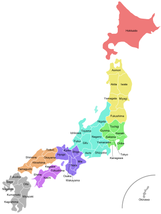
47 prefectural entities of Japan Regions and Prefectures of Japan 2.svg
47 prefectural entities of Japan

The top tier of administrative divisions are the 47 prefectural entities: 43 prefectures (, ken) proper, two urban prefectures (, fu, Osaka and Kyōto), one " circuit " (, , Hokkaidō), and one "metropolis" (, to, Tokyo Metropolis). Although different in name, they are functionally the same.

Ken

"Prefecture" (, ken) are the most common types of prefectural divisions total of 43 ken. The kanji (character) from which this is derived means "county".

To

Tokyo Metropolis is referred to as a "metropolis" (, to) after the dissolution of Tokyo City in 1943, Tōkyō-fu (Tokyo Prefecture) was upgraded into Tōkyō-to and the former Tokyo City's wards were upgraded into special wards. The kanji (character) from which this is derived means "capital".

Fu

Osaka Prefecture and Kyoto Prefecture are referred to as an "urban prefecture" (, fu). The Chinese character from which this is derived implies a core urban zone of national importance in the middle period of China, or implies a subdivision of a province in the late period of China.

Hokkaido is referred to as a "circuit" (, ), this term was originally used to refer to Japanese regions consisting of several provinces. This was also a historical usage of the character in China meaning circuit.

Subprefectural divisions

There are only two types of subprefectural divisions: subprefecture and district.

Subprefecture

Subprefectures (支庁, shichō) are a Japanese form of self-government which focuses on local issues below the prefectural level. It acts as part of the greater administration of the state and as part of a self-government system. [2]

District

Districts (, gun) were administrative units in use between 1878 and 1921 that were roughly equivalent to the counties of China or the United States. In the 1920s, municipal functions were transferred from district offices to the offices of the towns and villages within the district. District names remain in the postal address of towns and villages, and districts are sometimes used as boundaries for electoral districts, but otherwise serve no official function. The Classical Chinese character from which this is derived means commandery.

Municipal divisions

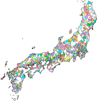
1,742 municipal and 175 submunicipal entities of Japan Japan Municipality Map.png
1,742 municipal and 175 submunicipal entities of Japan

The municipal divisions are divided into three main categories: city, town, and village. However, the city entities are further categorized. The Special wards of Tokyo are also considered to be municipal divisions.

Cities

Cities in Japan are categorized into four different types, from the highest the designated city, the core city, the special city, and the regular city at the lowest.

Designated city

A city designated by government ordinance (政令指定都市, seirei shitei toshi), also known as a designated city (指定都市, shitei toshi) or government ordinance city (政令市, seirei shi), is a Japanese city that has a population greater than 500,000 and has been designated as such by an order of the cabinet of Japan under Article 252, Section 19 of the Local Autonomy Law. Designated cities are also subdivided into wards.

Core city

A core city (中核市, Chūkakushi) is a Japanese city that has a population greater than 300,000 and an area greater than 100 square kilometers, although special exceptions may be made by order of the cabinet for cities with populations under 300,000 but over 200,000. [3] This category was created by the first clause of Article 252, Section 22 of the Local Autonomy Law of Japan.

Special city

A special city (特例市, Tokureishi) of Japan is a city with a population of at least 200,000. This category was established by the Local Autonomy Law, article 252 clause 26.

City

A city (, shi) is a local administrative unit in Japan with a population of at least 50,000 of which at least 60% of households must be established in a central urban area, and at least 60% of households must be employed in commerce, industry or other urban occupations. Cities are ranked on the same level as towns (, machi) and villages (, mura); the only difference is that they are not a component of districts (, gun). Like other contemporary administrative units, they are defined by the Local Autonomy Law of 1947.

Town

A town (, chō or machi) is a local administrative unit in Japan. It is a local public body along with prefecture (ken or other equivalents), city (shi), and village (mura). Geographically, a town is contained within a prefecture.

Village

A village (, mura, sometimes son) is a local administrative unit in Japan. It is a local public body along with prefecture (, ken, or other equivalents), city (, shi), and town (, chō, sometimes machi). Geographically, a village's extent is contained within a prefecture. It is larger than an actual settlement, being in actuality a subdivision of a rural district (, gun), which are subdivided into towns and villages with no overlap and no uncovered area.

Special Ward

The special wards (特別区, tokubetsu-ku) are 23 municipalities that together make up the core and the most populous part of Tokyo Metropolis, Japan. Together, they occupy the land that was originally the Tokyo City before it was abolished in 1943 to become part of the newly created Tokyo Metropolis. The special wards' structure was established under the Japanese Local Autonomy Act and is unique to Tokyo Metropolis.

Submunicipal divisions

Ward

A ward (, ku) is a subdivision of the cities of Japan that are large enough to have been designated by government ordinance. [4]

History

Although the details of local administration have changed dramatically over time, the basic outline of the current two-tiered system since the abolition of the han system by the Meiji government in 1871 are similar. Before the abolition of the han system, Japan was divided into provinces (, kuni) then subdivided into districts (, gun) and then villages (里/郷, sato) at the bottom.

Structural hierarchy

PrefecturalSubprefecturalMunicipalSubmunicipal
Prefectures
(excluding Tokyo Metropolis)
Subprefecture"designated city"Ward
 
DistrictTown
Village
none
SubprefectureDistrict
 "core city"
"special city"
City
 
MetropolisCity
Special wards
District
Subprefecture
Town
Village
LevelTypeKanjiRomajiNo.
PrefecturalTokyo Metropolisto1 Tokyo (東京都 Tōkyō-to)
"circuit"1 Hokkaido (北海道 Hokkaidō)
"urban prefecture"fu2 Kyoto Prefecture (京都府 Kyōto-fu) and Osaka Prefecture (大阪府 Ōsaka-fu)
Prefectureken43Prefectures except Tokyo, Hokkaido, Kyoto Prefecture and Osaka Prefecture
 SubprefecturalSubprefecture支庁shichō158
Districtgun374
Municipal"designated city"政令指定都市seirei shitei toshi20
"core city"中核市chūkaku-shi42
"special city"特例市tokurei-shi40
Cityshi792Including designated, core and special cities.
Townchōormachi743
Villagemuraorson183
Special ward区 (特別区)ku (tokubetsu-ku)23 Special wards of Tokyo (東京都区部 Tōkyō-to kubu), 23 wards of Tokyo (東京23区 Tōkyō nijūsan-ku)
 SubmunicipalWard区 (行政区)ku (gyōsei-ku)175Only used for designated cities
ISO Prefecture Kanji RegionCities [all-types]
(Special wards)
WardsDistrictsTownsVillages
JP-23Flag of Aichi Prefecture.svg  Aichi 愛知県 Chūbu 38167142
JP-05Flag of Akita Prefecture.svg  Akita 秋田県 Tōhoku 13693
JP-02Flag of Aomori Prefecture.svg  Aomori 青森県 Tōhoku 108228
JP-12Flag of Chiba.svg  Chiba 千葉県 Kantō 3766161
JP-38Flag of Ehime Prefecture.svg  Ehime 愛媛県 Shikoku 1179
JP-18Flag of Fukui Prefecture.svg  Fukui 福井県 Chūbu 9717
JP-40Flag of Fukuoka Prefecture.svg  Fukuoka 福岡県 Kyushu 281412302
JP-07Flag of Fukushima.svg  Fukushima 福島県 Tōhoku 13133115
JP-21Flag of Gifu Prefecture.svg  Gifu 岐阜県 Chūbu 219192
JP-10Flag of Gunma Prefecture.svg  Gunma 群馬県 Kantō 127158
JP-34Flag of Hiroshima Prefecture.svg  Hiroshima 広島県 Chūgoku 14859
JP-01Flag of Hokkaido Prefecture.svg  Hokkaidō 北海道 Hokkaido 35106612915 [1]
JP-28Flag of Hyogo.svg  Hyōgo 兵庫県 Kansai 299812
JP-08Flag of Ibaraki.svg  Ibaraki 茨城県 Kantō 327102
JP-17Flag of Ishikawa.svg  Ishikawa 石川県 Chūbu 1158
JP-03Flag of Iwate.svg  Iwate 岩手県 Tōhoku 1410154
JP-37Flag of Kagawa Prefecture.svg  Kagawa 香川県 Shikoku 859
JP-46Flag of Kagoshima Prefecture.svg  Kagoshima 鹿児島県 Kyushu 198204
JP-14Flag of Kanagawa.svg  Kanagawa 神奈川県 Kantō 19286131
JP-39Flag of Kochi.svg  Kōchi 高知県 Shikoku 116176
JP-43Flag of Kumamoto.svg  Kumamoto 熊本県 Kyushu 1459238
JP-26Flag of Kyoto Prefecture.svg  Kyōto 京都府 Kansai 15116101
JP-24Flag of Mie prefecture.svg  Mie 三重県 Kansai 14715
JP-04Flag of Miyagi Prefecture.svg  Miyagi 宮城県 Tōhoku 13510211
JP-45Flag of Miyazaki Prefecture.svg  Miyazaki 宮崎県 Kyushu 96143
JP-20Flag of Nagano Prefecture.svg  Nagano 長野県 Chūbu 19142335
JP-42Flag of Nagasaki Prefecture.svg  Nagasaki 長崎県 Kyushu 1348
JP-29Flag of Nara Prefecture.svg  Nara 奈良県 Kansai 1271512
JP-15Flag of Niigata Prefecture.svg  Niigata 新潟県 Chūbu 208964
JP-44Flag of Oita Prefecture.svg  Ōita 大分県 Kyushu 14331
JP-33Flag of Okayama Prefecture.svg  Okayama 岡山県 Chūgoku 15410102
JP-47Flag of Okinawa Prefecture.svg  Okinawa 沖縄県 Kyushu 1151119
JP-27Flag of Osaka.svg  Ōsaka 大阪府 Kansai 3331591
JP-41Flag of Saga Prefecture.svg  Saga 佐賀県 Kyushu 10610
JP-11Flag of Saitama.svg  Saitama 埼玉県 Kantō 40108221
JP-25Flag of Shiga Prefecture.svg  Shiga 滋賀県 Kansai 1336
JP-32Flag of Shimane.svg  Shimane 島根県 Chūgoku 85101
JP-22Flag of Shizuoka Prefecture.svg  Shizuoka 静岡県 Chūbu 236512
JP-09Flag of Tochigi.svg  Tochigi 栃木県 Kantō 14512
JP-36Flag of Tokushima.svg  Tokushima 徳島県 Shikoku 88151
JP-13Flag of Tokyo Metropolis.svg  Tōkyō 東京都 Kantō 26 (23) 1 5 8
JP-31Flag of Tottori Prefecture.svg  Tottori 鳥取県 Chūgoku 45141
JP-16Flag of Toyama Prefecture.svg  Toyama 富山県 Chūbu 10241
JP-30Flag of Wakayama Prefecture.svg  Wakayama 和歌山県 Kansai 96201
JP-06Flag of Yamagata Prefecture.svg  Yamagata 山形県 Tōhoku 138193
JP-35Flag of Yamaguchi Prefecture.svg  Yamaguchi 山口県 Chūgoku 1346
JP-19Flag of Yamanashi Prefecture.svg  Yamanashi 山梨県 Chūbu 13586
Total792 (23)175307743183

See also

Related Research Articles

<span class="mw-page-title-main">Prefectures of Japan</span> First-level administrative divisions of Japan

Japan is divided into 47 prefectures, which rank immediately below the national government and form the country's first level of jurisdiction and administrative division. They include 43 prefectures proper, two urban prefectures, one regional prefecture and one metropolis. In 1868, the Meiji Fuhanken sanchisei administration created the first prefectures to replace the urban and rural administrators in the parts of the country previously controlled directly by the shogunate and a few territories of rebels/shogunate loyalists who had not submitted to the new government such as Aizu/Wakamatsu. In 1871, all remaining feudal domains (han) were also transformed into prefectures, so that prefectures subdivided the whole country. In several waves of territorial consolidation, today's 47 prefectures were formed by the turn of the century. In many instances, these are contiguous with the ancient ritsuryō provinces of Japan.
<span class="mw-page-title-main">Cities of Japan</span>

A city is a local administrative unit in Japan. Cities are ranked on the same level as towns and villages, with the difference that they are not a component of districts. Like other contemporary administrative units, they are defined by the Local Autonomy Law of 1947.

<span class="mw-page-title-main">Districts of Japan</span> Administrative unit in Japan

In Japan, a district is composed of one or more rural municipalities within a prefecture. Districts have no governing function, and are only used for geographic or statistical purposes such as mailing addresses. Cities are not part of districts.

<span class="mw-page-title-main">Cities designated by government ordinance of Japan</span> Type of Japanese city

A city designated by government ordinance, also known as a designated city or government ordinance city, is a Japanese city that has a population greater than 500,000 and has been designated as such by order of the Cabinet of Japan under Article 252, Section 19, of the Local Autonomy Law.

The Japanese addressing system is used to identify a specific location in Japan.

<span class="mw-page-title-main">Tokyo City</span> 1889–1943 municipality in Japan

Tokyo City was a municipality in Japan and capital of Tokyo Prefecture which existed from 1 May 1889 until the establishment of Tokyo Metropolis on 1 July 1943. The historical boundaries of Tokyo City are now occupied by the special wards of Tokyo. The defunct city and its prefecture became what is now Tokyo, also known as the Tokyo Metropolis or, ambiguously, Tokyo Prefecture.

<span class="mw-page-title-main">Tokyo Prefecture (1868–1943)</span> Former Japanese government entity

Tokyo Prefecture was a Japanese government entity that existed between 1868 and 1943.
<span class="mw-page-title-main">Shiga District, Shiga</span>

Shiga was a district located in Shiga Prefecture, Japan.

<span class="mw-page-title-main">Nakanoshima, Niigata</span> Former municipality in Hokuriku, Japan

Nakanoshima was a town located in Minamikanbara District, Niigata Prefecture, Japan.

<span class="mw-page-title-main">Koshiji, Niigata</span> Former municipality in Hokuriku, Japan

Koshiji was a town located in Santō District, Niigata Prefecture, Japan.

<span class="mw-page-title-main">Mishima, Niigata</span> Former municipality in Hokuriku, Japan

Mishima was a town located in Santō District, Niigata Prefecture, Japan.

<span class="mw-page-title-main">Santō District, Niigata</span>

Santō is a district located in Niigata Prefecture, Japan.

<span class="mw-page-title-main">Yamakoshi, Niigata</span> Former municipality in Hokuriku, Japan

Yamakoshi was a village located in Koshi District, Niigata Prefecture, Japan.

<span class="mw-page-title-main">Koshi District, Niigata</span>

Koshi was a district located in Niigata Prefecture, Japan.

Japanese place names include names for geographic features, present and former administrative divisions, transportation facilities such as railroad stations, and historic sites in Japan. The article Japanese addressing system contains related information on postal addresses.

<span class="mw-page-title-main">Western Tokyo</span> Place in Honshū, Japan

Western Tokyo, known as the Tama area, Tama region or toka (都下) locally, in the Tokyo Metropolis consists of 30 ordinary municipalities, unlike the eastern part which consists of 23 special wards.

<span class="mw-page-title-main">Nagaoka, Niigata</span> Special city in Chūbu, Japan

Nagaoka is a city located in Niigata Prefecture, Japan. It is the second largest city in the prefecture, after the capital city of Niigata. As of 4 August 2021, the city had an estimated population of 264,611 in 109,283 households and a population density of 300 inhabitants per square kilometre (780/sq mi). The total area of the city was 891.06 square kilometres (344.04 sq mi).
References

  1. 1 2 Not inducing the six villages in the Kuril Islands dispute area.
  2. Imperial Japanese Commission to the Louisiana Purchase Exposition. (1903). Japan in the beginning of the 20th century, p. 80.
  3. "日本財団図書館(電子図書館)Revised Local Autonomy Law". nippon.zaidan.info.
  4. "Statistical Handbook of Japan 2008" by Statistics Bureau, Japan Archived 7 February 2013 at the Wayback Machine Chapter 17: Government System (Retrieved on 4 July 2009)