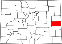
Aroya, Colorado (Arroyo) | |
---|---|
Coordinates: 38°51′15″N103°07′32″W / 38.85417°N 103.12556°W | |
Country | United States |
State | Colorado |
County | Cheyenne |
Elevation | 4,580 ft (1,400 m) |
Time zone | UTC-7 (MST) |
• Summer (DST) | UTC-6 (MDT) |
ZIP code | 80862 (Wild Horse) [2] |
Area code | 719 |
GNIS feature ID | 195190 |
Aroya is a small, rural, unincorporated community in Cheyenne County, Colorado, United States at the eastern end of State Highway 94 near its junction with U.S. Highway 40/U.S. Highway 287. [3]
The name Arroyo appears on some older maps. [1] The town was named "Aroya" because of a gulch nearby [4] ( arroyo is a Spanish word for "gulch"). The gulch is now named the Aroya Gulch. [5] Aroya originated in 1870 three miles west of the present site as a camp for Kansas-Pacific Railroad track-layers, but was moved to the present site because there was a better supply of water.
The Post Office at Wild Horse (ZIP Code 80862) serves Aroya postal addresses. [2] Aroya has an airfield (Maurer, altitude 4616 ft, inactive), a railroad (Union Pacific Railroad), and a cemetery (Aroya Cemetery [6] ) within a one-mile radius. [7] Aroya also has an old one-room schoolhouse that was in use until the early 1960s. [8]
The JOD Ranch nearby (named for Joseph Ottmar Dostal, initials J. O. D.) was founded in 1883, [9] and there have been ranching activities in the area since the 1870s. [10] Dostal was born in Rychnov nad Kneznou on 16 November 1842. [11] When Cheyenne County was formed in 1889, Joseph Dostal was the new county's largest property taxpayer. [4] The airplane landing strips nearby were a private airfield on JOD Ranch property. The airfield was named after Bill Maurer, [12] one of a number of subsequent owners of the JOD Ranch after it was founded by Joseph Dostal. The landing strips are barely visible because they were dirt and grass landing strips, and they were plowed under in the early 1980s in the process of an unsuccessful attempt to grow wheat after Bill Maurer sold the ranch. The building that was used for the hangar and the pole that was used for the windsock are still in existence.
Carl "Bev" Bledsoe, Colorado's longest serving Speaker of the State House of Representatives, was born in Aroya in 1923.
Burns is an unincorporated community in northern Eagle County, Colorado, United States.
Dresden Township is one of twelve townships in Chickasaw County, Iowa, USA. As of the 2000 census, its population was 822.
Lake City Township is a township in Barber County, Kansas, USA. As of the 2000 census, its population was 83.
Great Bend Township is a township in Barton County, Kansas, United States. As of the 2010 census, its population was 1,752.
Hiawatha Township is a township in Brown County, Kansas, USA. As of the 2000 census, its population was 739.
Benton Township is a township in Butler County, Kansas, USA. As of the 2000 census, its population was 2,211.
Pleasant Township is a township in Butler County, Kansas, USA. As of the 2000 census, its population was 4,649.
Jefferson Township is a township in Chautauqua County, Kansas, USA. As of the 2000 census, its population was 834.
Bird City Township is a township in Cheyenne County, Kansas, USA. As of the 2000 census, its population was 771.
Wano Township is a township in Cheyenne County, Kansas, USA. As of the 2000 census, its population was 2,104.
Greenfield Township is a township in Elk County, Kansas, USA. As of the 2000 census, its population was 321.
Liberty Township is a township in Elk County, Kansas, USA. As of the 2000 census, its population was 117.
Wheatland Township is a township in Ellis County, Kansas, USA. As of the 2010 census, its population was 386.
Bucklin Township is a township in Ford County, Kansas, USA. As of the 2000 census, its population was 900.
Jefferson Township is a township in Geary County, Kansas, USA. As of the 2000 census, its population was 1,651.
Jerome Township is a township in Gove County, Kansas, USA. As of the 2000 census, its population was 132.
Larrabee Township is a township in Gove County, Kansas, USA. As of the 2000 census, its population was 80.
Janesville Township is a township in Greenwood County, Kansas, USA. As of the 2000 census, its population was 548.
Twin Grove Township is a township in Greenwood County, Kansas, USA. As of the 2000 census, its population was 601.
Hall Station is a small rural locale in Lincoln County, Colorado, United States on the northeast corner of the intersection of State Highway 94 and County Road 11. Hall Station is a 101 by 211 ft grass/dirt area, suitable for parking, and fenced on three sides. Despite the name, the nearest railroad is 39 miles (62 km) east and 52 miles (84 km) west. Hall Station is located on Highway 94 two miles (3 km) south of the Elbert County line between the Highway 94 bridge crossings of Little Horse Creek and Horse Creek. The nearest U.S. Post Office is in Rush.