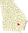
Bacon County | |
---|---|
Coordinates: 31°34′N82°27′W / 31.56°N 82.45°W | |
Country | United States |
State | Georgia |
Founded | July 27, 1914 |
Named for | Augustus Octavius Bacon |
Seat | Alma |
Largest city | Alma |
Area | |
• Total | 286 sq mi (740 km2) |
• Land | 259 sq mi (670 km2) |
• Water | 27 sq mi (70 km2) 9.5% |
Population (2020) | |
• Total | 11,140 |
• Density | 43/sq mi (17/km2) |
Time zone | UTC−5 (Eastern) |
• Summer (DST) | UTC−4 (EDT) |
Congressional district | 1st |
Bacon County is a county located in the southeastern part of the U.S. state of Georgia. As of the 2020 census, the population was 11,140. [1] The county seat is Alma. [2]
The constitutional amendment to create the county was proposed July 7, 1914, and ratified November 3, 1914. It is named after Augustus Bacon, a former United States senator from Georgia. [3]
According to the U.S. Census Bureau, the county has a total area of 286 square miles (740 km2), of which 259 square miles (670 km2) are land and 27 square miles (70 km2) (9.5%) are covered by water. [4]
The majority and western portion of Bacon County is located in the Satilla River sub-basin of the St. Marys River-Satilla River basin. The entire eastern and half of the southeastern edge of the county is located in the Little Satilla River sub-basin of the same St. Marys-Satilla River basin. [5] The county forms part of Southeast Georgia.
Census | Pop. | Note | %± |
---|---|---|---|
1920 | 6,460 | — | |
1930 | 7,055 | 9.2% | |
1940 | 8,096 | 14.8% | |
1950 | 8,940 | 10.4% | |
1960 | 8,359 | −6.5% | |
1970 | 8,233 | −1.5% | |
1980 | 9,379 | 13.9% | |
1990 | 9,566 | 2.0% | |
2000 | 10,103 | 5.6% | |
2010 | 11,096 | 9.8% | |
2020 | 11,140 | 0.4% | |
2023 (est.) | 11,124 | [6] | −0.1% |
U.S. Decennial Census [7] 1790-1880 [8] 1890-1910 [9] 1920-1930 [10] 1930-1940 [11] 1940-1950 [12] 1960-1980 [13] 1980-2000 [14] 2010 [15] |
Race | Num. | Perc. |
---|---|---|
White (non-Hispanic) | 8,103 | 72.74% |
Black or African American (non-Hispanic) | 1,747 | 15.68% |
Native American | 4 | 0.04% |
Asian | 40 | 0.36% |
Pacific Islander | 4 | 0.04% |
Other/Mixed | 367 | 3.29% |
Hispanic or Latino | 875 | 7.85% |
According to the 1920 United States census, the county had a population of 6,460 which has increased since every decennial census except from 1960 and 1970; in 1960, its population declined from 8,940 to 8,359; and in 1970, its population declined to 8,233. In the 2020 United States census, there were 11,140 people, 3,874 households, and 2,706 families residing in the county, up from 10,103 in 2000.
Per the 2020 census, Bacon County's racial and ethnic makeup was 72.74% non-Hispanic white, 15.68% Black or African American, 0.04% Native American, 0.36% Asian American, 0.04% Pacific Islander American, 3.29% other or multiracial, and 7.85% Hispanic or Latino of any race. The 2022 American Community Survey estimated its racial and ethnic composition was 73% White, 15% African American, 1% Asian, 3% multiracial, and 9% Hispanic or Latino of any race. [17]
In 2022, the median household income for the county was $43,938 with a per capita income of $24,654. An estimated 21.6% of the county population lived at or below the poverty line. With an estimated 4,807 housing units in the county, 72% were owner-occupied and the median value of an owner-occupied housing unit was $95,600. Approximately 53% of housing units were valued under $100,000. [17]
Religiously, as of 2020, the Association of Religion Data Archives determined the Southern Baptist Convention was the county's largest religious group, being within the Bible Belt. [18] The Church of God (Cleveland, Tennessee) was the second-largest Christian denomination in the county, followed by the Church of Jesus Christ of Latter-day Saints and National Association of Free Will Baptists. Among the county's predominantly Christian population, Methodists, Holiness, and Pentecostal Christians formed the remainder of its religious landscape.
Year | Republican | Democratic | Third party(ies) | |||
---|---|---|---|---|---|---|
No. | % | No. | % | No. | % | |
2024 | 4,186 | 86.51% | 645 | 13.33% | 8 | 0.17% |
2020 | 4,017 | 86.07% | 625 | 13.39% | 25 | 0.54% |
2016 | 3,364 | 83.49% | 608 | 15.09% | 57 | 1.41% |
2012 | 3,093 | 78.58% | 791 | 20.10% | 52 | 1.32% |
2008 | 3,089 | 78.36% | 817 | 20.73% | 36 | 0.91% |
2004 | 2,853 | 75.24% | 930 | 24.53% | 9 | 0.24% |
2000 | 2,010 | 67.11% | 956 | 31.92% | 29 | 0.97% |
1996 | 1,580 | 47.07% | 1,360 | 40.51% | 417 | 12.42% |
1992 | 1,301 | 39.01% | 1,423 | 42.67% | 611 | 18.32% |
1988 | 1,407 | 64.13% | 780 | 35.55% | 7 | 0.32% |
1984 | 1,778 | 63.77% | 1,010 | 36.23% | 0 | 0.00% |
1980 | 1,427 | 45.94% | 1,622 | 52.22% | 57 | 1.84% |
1976 | 594 | 19.87% | 2,395 | 80.13% | 0 | 0.00% |
1972 | 1,771 | 90.22% | 192 | 9.78% | 0 | 0.00% |
1968 | 586 | 20.93% | 279 | 9.96% | 1,935 | 69.11% |
1964 | 2,136 | 64.43% | 1,179 | 35.57% | 0 | 0.00% |
1960 | 579 | 33.14% | 1,168 | 66.86% | 0 | 0.00% |
1956 | 394 | 13.88% | 2,445 | 86.12% | 0 | 0.00% |
1952 | 543 | 26.42% | 1,512 | 73.58% | 0 | 0.00% |
1948 | 104 | 8.42% | 785 | 63.56% | 346 | 28.02% |
1944 | 220 | 22.38% | 763 | 77.62% | 0 | 0.00% |
1940 | 97 | 10.51% | 821 | 88.95% | 5 | 0.54% |
1936 | 62 | 6.26% | 929 | 93.74% | 0 | 0.00% |
1932 | 11 | 2.08% | 515 | 97.54% | 2 | 0.38% |
1928 | 203 | 39.96% | 305 | 60.04% | 0 | 0.00% |
1924 | 79 | 7.49% | 961 | 91.09% | 15 | 1.42% |
1920 | 219 | 41.63% | 307 | 58.37% | 0 | 0.00% |
1916 | 0 | 0.00% | 287 | 86.19% | 46 | 13.81% |
Washington County is a county located in the U.S. state of Georgia. As of the 2020 census, the population was 19,988. The county seat is Sandersville. The county was established on February 25, 1784. It was named for Revolutionary War general and President of the United States George Washington.
Ware County is a county located in the southeastern part of the U.S. state of Georgia. As of the 2020 census, the population was 36,251. The county seat and only incorporated place is Waycross. Ware County is part of the Waycross, Georgia micropolitan statistical area.
Seminole County is a county located in the southwestern corner of U.S. state of Georgia. As of the 2020 census, the population was 9,147. The county seat is Donalsonville.
Richmond County is located in the state of Georgia in the U.S. As of the 2020 census, the population was 206,607. It is one of the original counties of Georgia, created on February 5, 1777. Following an election in 1995, Augusta consolidated governments with Richmond County. The consolidated entity is known as Augusta-Richmond County, or simply Augusta. Exempt are the cities of Hephzibah and Blythe, in southern Richmond County, which voted to remain separate. Richmond County is included in the Augusta-Richmond County, GA-SC metropolitan statistical area.
Randolph County is a county located in the southwestern portion of the U.S. state of Georgia and is considered part of the Black Belt, historically an area of plantations. As of the 2020 census, the population was 6,425, roughly one-third of its peak population in 1910, when there were numerous agricultural workers. The county seat is Cuthbert.
Pierce County is a county located in the southeastern part of the U.S. state of Georgia. As of the 2020 census, the population was 19,716. The county seat is Blackshear. Pierce County is part of the Waycross, Georgia Micropolitan Statistical Area.
Miller County is a county located in the southwestern part of the U.S. state of Georgia. As of the 2020 census, the population was 6,000. The county seat is Colquitt. The county was created on February 26, 1856, and named after Andrew Jackson Miller (1806–56), president of the Medical College of Georgia.
Lamar County is a county in the West Central region the U.S. state of Georgia. As of the 2020 census, the population was 18,500. The county seat is Barnesville.
Johnson County is a county located along the Oconee River in the U.S. state of Georgia. As of the 2020 census, the population was 9,189. The county seat is Wrightsville. Johnson County is part of the Dublin, Georgia, micropolitan statistical area.
Jefferson County is a county located in the U.S. state of Georgia. As of the 2020 census, the population was 15,709. The county seat and largest city is Louisville. The county was created on February 20, 1796, and named for Thomas Jefferson, the main author of the Declaration of Independence who became the third president of the United States.
Jeff Davis County is a county located in the southeastern part of the U.S. state of Georgia. As of the 2020 census, the population was 14,779. The county seat is Hazlehurst. The county was created on August 18, 1905, and named for Jefferson Davis, the only Confederate president.
Hart County is a county in the Northeast region of the U.S. state of Georgia. As of the 2020 census, the population was 25,828. The county seat is Hartwell.
Coffee County is a county located in the southeastern part of the U.S. state of Georgia. As of the 2020 census, the population was 43,092, up from 42,356 at the 2010 census. The county seat is Douglas.
Charlton County is the southernmost county of the U.S. state of Georgia, located in the southeastern part of the state. As of the 2020 census, the population was 12,518. The county seat is Folkston.
Burke County is a county located along the eastern border of the U.S. state of Georgia in the Piedmont. As of the 2020 census, the population was 24,596. The county seat is Waynesboro. Burke County is part of the Augusta-Richmond County, GA-SC metropolitan statistical area.
Brantley County is a county located in the southeastern part of the U.S. state of Georgia. As of the 2020 census, the population was 18,021. The county seat is Nahunta. Brantley County is part of the Brunswick, Georgia metropolitan statistical area.
Ben Hill County is a county located in the U.S. state of Georgia. As of the 2020 census, the population was 17,194. The county seat is Fitzgerald. The county was organized in 1906. It is named after Benjamin Harvey Hill, a former Confederate and United States Senator.
Baker County is a county in Georgia. As of the 2020 census, the population was 2,876, making it the fifth-least populous county in Georgia. The county seat and only city is Newton. The county was created December 12, 1825, from the eastern portion of Early County by an act of the Georgia General Assembly and is named for Colonel John Baker, a hero of the American Revolutionary War.
Atkinson County is a county located in the southeastern region of the U.S. state of Georgia. As of the 2020 census, the county's population was 8,286. The county seat is Pearson. The county was formed in 1917 from parts of Coffee and Clinch counties. It is named for William Yates Atkinson, Democratic governor of Georgia from 1894 to 1898. In 2003, it had the highest illiteracy rate of any U.S. county at 36%.
Appling County is a county located in the southeastern part of the U.S. state of Georgia. As of the 2020 census, the population was 18,444. The county seat is Baxley.