Bilaspur–Leh line

Last updated

Bilaspur–Leh line
Overview
Status
  • Survey done
  • Feasibility Report done
  • Submission to Planning Commission for appraisal done
  • Approval by Planning Commission yes
  • Land Acquisition In progress
  • Construction no
Locale Himachal Pradesh and Ladakh, India
Termini
Website http://www.indianrailways.gov.in
Service
Services BilaspurSundernagarKulluManaliKeylongLeh
Technical
Line length498 km (309 mi)
Track length498 km (309 mi)
Track gauge 1,676 mm (5 ft 6 in)
Electrification proposed
Highest elevation5,359 m (17,582 ft) at Taglang La
Route map

Contents

BSicon exCONTg.svg
Srinagar (planned)
BSicon exBHF.svg
Leh
BSicon exHST.svg
Choglamshahr
BSicon exHST.svg
Sindhughat
BSicon exHST.svg
Shey
BSicon exHST.svg
Thicksey
BSicon exHST.svg
Rabirpora
BSicon exHST.svg
Chang-Karu
BSicon exBHF.svg
Upshi-Junction
BSicon exHST.svg
Rumtse
BSicon exHST.svg
Taglang La
BSicon exHST.svg
Debring
BSicon exHST.svg
Pang
BSicon exHST.svg
Lachalungla
BSicon exHST.svg
Sarchu
BSicon exHST.svg
Baralachala
BSicon exHST.svg
Dharcha
BSicon exHST.svg
Jispa
BSicon exHST.svg
Keylong
BSicon exHST.svg
Tandi
BSicon exHST.svg
Sissu
BSicon exHST.svg
Rohtang Hault
BSicon exBHF.svg
Manali
BSicon exHST.svg
Naggar
BSicon exBHF.svg
Kullu
BSicon exHST.svg
Bhuntar
BSicon exHST.svg
Aut
BSicon exHST.svg
Pandoh
BSicon exCONTgq.svg
BSicon exABZg+r.svg
Joginder Nagar (planned)
BSicon exBHF.svg
Mandi
BSicon exBHF.svg
Bilaspur
BSicon exSTR.svg
↑planned
BSicon KBHFxa.svg
Kalka
BSicon CONTf.svg

Bilaspur–Manali-Leh line is an under-construction high-elevation all-weather 1,676 mm (5 ft 6 in) broad gauge railway track connecting Bilaspur in Himachal Pradesh to Leh in Ladakh union territory of India. [1] [2] [3] It will connect major hill towns of Bilaspur, Mandi, Kullu, Manali, Keylong and Leh.

465-km-long line at a height of 5360m above mean sea level with 10 hours travel time from New Delhi to Leh will become the highest railway in the world surpassing Qinghai–Tibet Railway in China at 2000m. [4] The Bhanupali-Bilaspur–Leh line, with the total length of 476 km (296 miles) excluding 13 km (8.1 miles) Leh-Sasherthang military rail link, will cost INR99,000 crore (~US$12.4 billion) including INR62,0000 crore (~US$7.75 billion) for the tunnels and bridges. Construction will be completed in phases, Phase-0 Bhanupali to Beri-Barmana (Bilaspur), Phase-1 Beri-Barmana to Mandi, Phase-2 Mandi to Manali, Phase-3 Manali to Upshi, Phase-4 Upshi to Leh, Phase-5 Leh to Sasherthang 13 km extension link for the Indian Military. [1] Bilaspur-Leh line would link to the Indian railway network via the 63.1 km long under-construction railway line from the existing Bhanupali railway station in Punjab (on existing Ambala-Sirhind-Una rail line) to Barmana in Bilaspur district in Himachal Pradesh. [1] As of Feb 2022, the completion date for the under-construction phase-0 Bhanupali to Barmana (Bilaspur) track is 2025 and for the phase-1 Barmana to Leh line the land acquisition has commenced for the Barmana to Mandi section. [5]

History

The Chief Minister of Himachal Pradesh asked the Government of India to extend railway connectivity from Bilaspur to Leh through Mandi, Manali and Keylong. This would increase tourism in Himachal Pradesh and Ladakh and facilitate quicker movement of troops and equipment. [2] [3] Following an examination of the feasibility report for the proposed Bilaspur–Leh line, the Union Railway Ministry of India forwarded the recommendation to the Planning Commission of India for its approval. [6] The survey for the project had been done and presently it is seeking approval of the planning commission of India and while railway minister assured about early clearance of this project.

Strategic importance

Once this railway line is completed, Leh will be directly connected to Himachal Pradesh and the rest of India by railway. The distance between Bilaspur and Leh will be about 460 km (290 mi). When the railway lines to Bilaspur and then to Leh are completed, the time taken to reach Leh from Delhi will be reduced to less than two days compared to about four days by the existing highway from Manali. Personnel and equipment will be transported more easily to Leh, a strategic military base. This is one of the four important railway connectivity along China border identified by the Defence Ministry. [7]

Post Galwan clash with China, The Government of India expedited the land acquisition for the project. [8]

Project details

Construction challenges

After Jammu–Baramulla line, Bilaspur–Leh line will be the most challenging railway project in Indian Railways due to high mountains, a large number of tunnels and high bridges and severe cold weather.[ original research? ] According to the survey report, cost of construction of this 458 km (285 mi) long all-weather broad-gauge railway line has been calculated at 83,360 crore (~USD 11.3 bn at time of publication [9] ) with a negative rate of return of 4.46%. [10]

Taglang La station: world's highest railway station

Taglang La Tanglanglapass.jpg
Taglang La

Taglang La railway station at Taglang La will become the highest railway station in the world at 5,359 m (17,582 ft) above the sea level overtaking the current record of Tanggula railway station in Qinghai, China at 5,086 m (16,686 ft)

Military requirements

To cater for the military logistics, the loop line will be constructed at 5 stations for the exclusive use of military loading and unloading at Karu, Sissu, Debring, Leh and Sesharthang. Rail line will be extended 13 km from Leh to Sesharthang to meet military logistics. [1]

Construction phases

Bhanupali-Manali-Leh railway line project will require acquisition of 1100 hectares land, of which 26% is forest land, costing INR11,500 crore (US$8.5 billion). 150 km of approach roads will be constructed. [1]

Phase-0: Bhanupali to Barmana (Bilaspur), 63.1 km

Phase-0, from the existing Bhanupali railway station in Rupnagar district of Punjab state on Ambala-Sirhind-Una railway line to Barmana in Bilaspur district in Himachal Pradesh state, has total track length of 63.1 km, 20 tunnels of total 25 km length, 24 bridges of total 6 km length and 2 viaducts of 2 km length. Of these, only 7 tunnels are part of phase-0a (Bhanupali in Punjab to Dharot in Naina Devi tehsil of Bilaspur district of Himachal Pradesh). Rest of tunnels and both viaducts are in the phase-0b. There are 5 main stations in this phase, one in Punjab at Thural, and 4 in Himachal Pradesh at Dharot, Jagatkhana, Bilaspur and Barmana. [5] [11]

Phase-1: (Barmana) Bilaspur to Mandi, ?? km, under land acquisition

Land acquisition between Barmana and Mandi for this phase is underway as of May 2022. [12]

Phase-2: Mandi to Manali, ?? km, under land acquisition

This section lies entirely within Himachal Pradesh. [1]

Phase-3: Manali to Upshi, ?? km, under land acquisition

This section connects Himachal Pradesh to Ladakh. [1]

Phase-4: Upshi to Leh, ?? km, under land acquisition

This section lies entirely within Ladakh. [1]

Phase-5: Leh to Sasherthang military link, 13 km, under planning

This section, which lies entirely within Ladakh, will serve Indian military's logistics needs on India-China LAC, India-Pakistan LOC in Ladakh and Kashmir, and India-Pakistan AGPL in Siachen. This section has a tunnel and a bridge. [1]

Present status of construction progress

See also

Related Research Articles

<span class="mw-page-title-main">Manali, Himachal Pradesh</span> Town in India

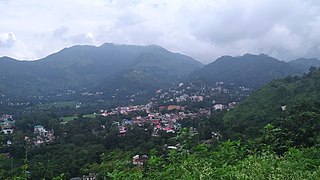
Manali is a town, near Kullu town in Kullu district in the Indian state of Himachal Pradesh. It is situated in the northern end of the Kullu Valley, formed by the Beas River. The town is located in the Kullu district, approximately 270 kilometres (170 mi) north of the state capital of Shimla and 544 kilometres (338 mi) northeast of the national capital of New Delhi. With a population of 8,096 people recorded in the 2011 Indian census Manali is the beginning of an ancient trade route through Lahaul (H.P) and Ladakh, over the Karakoram Pass and onto Yarkand and Hotan in the Tarim Basin of China. Manali is a popular tourist destination in India and serves as the gateway to the Lahaul and Spiti district as well as the city of Leh in Ladakh.

<span class="mw-page-title-main">Mountain railways of India</span> 19th-century narrow-gauge railway lines in India

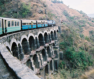
The Mountain railways of India are the railway lines that were built in the mountainous regions of India. The term mainly includes the narrow-gauge railway lines in these regions but may also include some broad gauge railways.

<span class="mw-page-title-main">Pir Panjal Range</span> Mountain range of the Lower Himalayas

The Pir Panjal Range is a group of mountains in the Lesser Himalayan region, running from east-southeast (ESE) to west-northwest (WNW) across the Indian territories of Himachal Pradesh and Jammu and Kashmir and then Pakistan's Azad Kashmir and Punjab. The average elevation varies from 1,400 m (4,600 ft) to 4,100 m (13,500 ft). The Himalayas show a gradual elevation towards the Dhauladhar and Pir Panjal ranges. Pir Panjal is the largest range of the Lesser Himalayas. Near the bank of the Sutlej River, it dissociates itself from the Himalayas and forms a divide between the Beas and Ravi rivers on one side and the Chenab on the other. The renowned Galyat mountains are also located in this range.

<span class="mw-page-title-main">Leh district</span> District of Ladakh in India

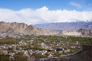
Leh district is a district in the union territory of Ladakh, India. With an area of 45,110 km2, it is the second largest district in the country smaller only to Kutch. It is bounded on the north by Gilgit-Baltistan's Kharmang and Ghanche districts and Xinjiang's Kashgar Prefecture and Hotan Prefecture linked via the historic Karakoram Pass. It has Aksai Chin and Tibet are to the east, Kargil district to the west, and Lahul and Spiti to the south. The district headquarters is in Leh. It lies between 32 to 36 degree north latitude and 75 to 80 degree east longitude.

<span class="mw-page-title-main">Bara-lacha la</span> Mountain pass in Himachal Pradesh, India

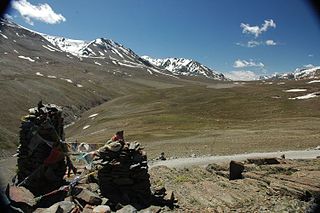
Bara-lacha la also known as Bara-lacha Pass, or Bārā Lācha La, is a high mountain pass in the Zanskar range of Northern-India, connecting Lahaul district in Himachal Pradesh to Leh district in Ladakh. Rail-cum-road tunnels are being constructed under the Bara-lacha la, Lungalacha La and Taglang La to cater for the traffic on existing NH3 Leh–Manali Highway & under-construction Bilaspur–Leh line.

<span class="mw-page-title-main">Shingo La</span>

Shingo-La is a mountain pass in India, on the border between Ladakh and Himachal Pradesh.

<span class="mw-page-title-main">Lungalacha La</span>

Lachulung La, or Lāchālūng La or Lungalacha La, is a paved motorable mountain pass in Ladakh in India just north of border with Himachal Pradesh. It is located on the NH3 Leh–Manali Highway, 54 km (34 mi) north of Sarchu and 24 km (15 mi) west of Pang. Rail-cum-road tunnel is being constructed under this pass to cater for the traffic for existing NH3 & under-construction Bilaspur–Leh line, Bara-lacha la and Taglang La are other tunnels being constructed on this route.

<span class="mw-page-title-main">Sundar Nagar</span> Town in Himachal Pradesh, India

Sundar Nagar is a town and a municipal council in Mandi district in the Indian state of Himachal Pradesh. Formerly it was a princely state, known as Suket.

<span class="mw-page-title-main">Taglang La</span>

Taglang La or Tanglang La, elevation 5,328 metres (17,480 ft), is a high altitude mountain pass in the Indian union territory of Ladakh. It is located on the NH3 Leh–Manali Highway. Rail-cum-road tunnels are being constructed under the Taglang La, Lungalacha La and Bara-lacha la to cater for the traffic from existing NH3 & under-construction Bilaspur–Leh line.

<span class="mw-page-title-main">Leh–Manali Highway</span> High elevation mountain highway in India

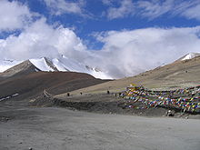
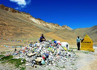
The Leh–Manali Highway is a 428 km (266 mi) long highway in northernmost India connecting Leh, the capital of the union territory of Ladakh, to Manali in the state of Himachal Pradesh. It connects the Manali Solang valley to the Lahaul and Spiti valleys in Himachal Pradesh and the Zanskar valley in Ladakh. It is open for about six months in a year, from first week of May to October, when snowfall again blocks the high passes on the highway. However, the Lahaul valley now remains connected to Manali for most part of the year through already completed Atal tunnel. With the completion of proposed Shingo La Tunnel on new route through Zanskar valley, targeted to be completed by 2025, the whole Leh-Manali route will become all-weather road.

The development of tribal areas in Himachal Pradesh is one of the major steps taken by the state government for its economic development. The border districts of Kinnaur, Lahaul, Spiti and the Pangi and Bharmour tehsils of Chamba districts are the major tribal areas of the state. They are located near the borders of Tibet and Indian States of Jammu and Kashmir. Other backward areas include Shillai in Sirmaur district, and deep cut-off valleys in the Kullu and upper stretches of Kangra districts. Due to poor accessibility, life in these areas had grown in isolation.

<span class="mw-page-title-main">Sissu</span> Town in Himachal Pradesh, India

Sissu is a small town in the Lahaul valley of Himachal Pradesh in India. It is around 40 km from Manali and located on the right bank of Chandra river. It is located at 32°29′0″N77°7′0″E. It is 3,120 m above sea level. It is 14 km from Koksar to the south-east and 11 km. west to Gondhla.

<span class="mw-page-title-main">Atal Tunnel</span> Highway tunnel of the Himalayas

Atal Tunnel, named after former Prime Minister of India, Atal Bihari Vajpayee is a highway tunnel built under the Rohtang Pass in the eastern Pir Panjal range of the Himalayas on the Leh-Manali Highway in Himachal Pradesh, India. At a length of 9.02 km, it is the world's highest highway single-tube tunnel above 10,000 feet (3,048 m) in the world. With the existing Atal Tunnel and after the completion of under-construction Shinku La Tunnel, which is targeted to be completed by 2025, the new Leh-Manali Highway via Nimmu–Padum–Darcha road will become all-weather roads.

<span class="mw-page-title-main">National Highway 3 (India)</span> National Highway in India

National Highway 3, or NH 3, is a national highway in India. It starts from Atari adjacent to India-Pakistan border and near Amritsar and terminates at Leh in Ladakh, via Manali in Himachal Pradesh.

<span class="mw-page-title-main">Tourism in Himachal Pradesh</span> Tourism in the Indian state of Himachal Pradesh

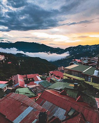
Tourism in Himachal Pradesh relates to tourism in the Indian state of Himachal Pradesh. This is popularly renowned for its Himalayan landscapes and popular hill-stations. Many outdoor activities such as rock climbing, mountain biking, paragliding, ice-skating, trekking, rafting, and heli-skiing are popular tourist attractions in Himachal Pradesh.

<span class="mw-page-title-main">Jahu, Himachal Pradesh</span> Village in Himachal Pradesh, India

Jahu is a village panchayat, of Bhoranj block, Bhoranj tehsil, of the Hamirpur district of Himachal Pradesh, in India. Hamirpur is one of twelve districts in Himachal Pradesh. Pin Code of Jahu Village is 176 048 and People of Jahu Village use Hindi and Pahadi Language for communication.

<span class="mw-page-title-main">Future of rail transport in India</span> Overview of Indian programme to upgrade railways

The Indian Government is undertaking several initiatives to upgrade its aging railway infrastructure and enhance its quality of service. The Railway Ministry has announced plans to invest 5,400,000 crore (US$680 billion) to upgrade the railways by 2030. Upgrades include 100% electrification of railways, upgrading existing lines with more facilities and higher speeds, expansion of new lines, upgrading railway stations, introducing and eventually developing a large high-speed train network interconnecting major cities in different parts of India and development of various dedicated freight corridors to cut down cargo costs within the country.

<span class="mw-page-title-main">Railway in Haryana</span>

Rail network in the state of Haryana in India, is covered by 5 rail divisions under 3 rail zones, namely, North Western Railway zone, Northern Railway zone and North Central Railway zone.

<span class="mw-page-title-main">India-China Border Roads</span> Indian government project to develop border roads

India-China Border Roads is a Government of India project for developing infrastructure along the Sino-Indian border by constructing strategic roads, including bridges and tunnels. The ICBR project is largely in response to Chinese infrastructure development along the borderlands with India.

<span class="mw-page-title-main">Karu, Ladakh</span> Village in Ladakh, India

Kharu, also spelt Karu, is a town, subdivision, tehsil, block, tourist station and military base on the bank of Indus River in the Leh district of Union territory of Ladakh in India. It is located 34 km southeast of Leh on Leh-Manali Highway and under-construction Bilaspur–Leh line. Karu is one of the important railway station and military's railway logistics hub on the under construction Bilaspur–Leh line of Indian Railway. Karu is an important transit point where several strategic and important road arterial and feeder routes of India-China Border Roads meet, such as Leh-Manali Highway, Leh-Nyoma road, Hamis-Karo-Pangong Tso road, etc.

References

  1. 1 2 3 4 5 6 7 8 9 10 "डीपीआर तैयार: सेना के लिए चीन सीमा तक अलग से बिछेगा 13 किलोमीटर रेल ट्रैक". Amar Ujala. Retrieved 14 September 2022.
  2. 1 2 "Himachal: Railways Awards Bhanupali-Bilaspur Railway Line Project". Nvonews.com. 19 September 2009. Archived from the original on 7 April 2012. Retrieved 2 April 2012.
  3. 1 2 "Rail link to Leh: Centre seeks Plan panel nod". visitladakh.com. Archived from the original on 12 March 2012. Retrieved 2 April 2012.
  4. "Leh? Soon, It'll Be Just a Train Ride Away". Outlook Traveller. Retrieved 31 October 2018.
  5. 1 2 3 , Amar Ujala, 24 April 2022.
  6. 1 2 "'Manali–Leh railway line project report with Planning Commission'". Himvani.com. 26 December 2010. Archived from the original on 26 February 2020. Retrieved 2 April 2012.{{cite web}}: CS1 maint: unfit URL (link)
  7. "Four places along China border identified for rail connectivity: Government". The Economic Times . 22 December 2014. Retrieved 22 December 2014.
  8. Manta, Dipender (22 June 2020). "Centre expedites land acquisition for Bilaspur-Leh railway line". Tribune India. Archived from the original on 23 June 2020. Retrieved 22 July 2020.
  9. "US Dollar (USD) to Indian Rupee (INR) Historical Exchange Rates on 18th October 2018". www.exchangerates.org.uk. Retrieved 18 July 2021.
  10. "Railways seeks central funding for Bilaspur-Leh project on India-China border". The New Indian Express. 18 October 2018. Archived from the original on 18 October 2018. Retrieved 16 January 2022.
  11. 1 2 रेल विकास निगम: भानुपल्ली-बिलासपुर-लेह रेललाइन के लिए बिछने लगा ट्रैक, Amar Ujala, 15 May 2022.
  12. 1 2 "Land acquisition for strategic rail line begins in Himachal". 9 February 2022.
  13. "Budget 2012-2013 Speech of Dinesh Trivedi Minister of Railways. March 14, 2012" (PDF). Archived from the original (PDF) on 24 March 2012. Retrieved 31 March 2012.
  14. "Bilaspur-Manali-Leh rail line on fast track". The Times of India. 3 December 2016. Archived from the original on 4 December 2016. Retrieved 16 January 2022.
  15. "Centre announces final location survey of three railway lines in Arunachal Pradesh". The New Indian Express. PTI. 1 April 2017. Archived from the original on 7 November 2017. Retrieved 16 January 2022.{{cite web}}: CS1 maint: others (link)
  16. Khosla, Sakshita (27 June 2017). "Train to Leh, Ladakh: Suresh Prabhu lays foundation stone for Bilaspur-Mandi-Leh Rail Line to be built at a cost of Rs 157 cr". India.com. Archived from the original on 29 June 2017.