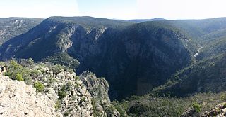
The Barwon River is a perennial river of the Corangamite catchment, located in The Otways and the Bellarine Peninsula regions of the Australian state of Victoria.
Lake Corangamite, a hypersaline endorheic lake, is located near Colac in the Lakes and Craters region of the Victorian Volcanic Plains of south-west Victoria, Australia. The lake's salinity levels have increased dramatically as the lake level has dropped in recent decades. It is Australia's largest permanent saline lake, covering approximately 230 square kilometres (89 sq mi) with a circumference of 150 kilometres (93 mi). It forms part of the Ramsar-listed Western District Lakes wetland site. The indigenous name of the lake is recorded as Kronimite.
The Kennet River, now commonly spelt Kennett River, is a perennial river of the Corangamite catchment, located in the Otways region of the Australian state of Victoria.

The Parker River is a perennial river of the Corangamite catchment, located in the Otways region of the Australian state of Victoria.
The Gellibrand River is a perennial river of the Corangamite catchment, located in the Otways region of the Australian state of Victoria.
The Johanna River is a perennial river of the Corangamite catchment, located in the Otways region of the Australian state of Victoria.

The Aire River is a perennial river of the Corangamite catchment, located in the Otways region of the Australian state of Victoria.
The Ford River is a perennial river of the Corangamite catchment, located in the Otways region of the Australian state of Victoria.
The Calder River is a perennial river of the Corangamite catchment, located in the Otways region of the Australian state of Victoria.
The Geary River is a perennial river of the Corangamite catchment, located in the Otways region of the Australian state of Victoria.
The Elliott River is a perennial river of the Corangamite catchment, located in the Otways region of the Australian state of Victoria.

The Barham River is a perennial river of the Corangamite catchment, located in the Otways region of the Australian state of Victoria.
The Grey River is a perennial river of the Corangamite catchment, located in the Otways region of the Australian state of Victoria.

The Wye River is a perennial river of the Corangamite catchment, located in the Otways region of the Australian state of Victoria.
The St George River, or sometimes incorrectly Saint George River, is a perennial river of the Corangamite catchment, located in the Otways region of the Australian state of Victoria.

The Yarrowee River is a perennial river of the Corangamite catchment, located in the Central Highlands region of the Australian state of Victoria.

The Little River is a perennial river of the Snowy River catchment, located in the Alpine region of the Australian state of Victoria. It is one of two rivers of the same name that are tributaries of the Snowy River, the other being the Little River.

The Leigh River is a perennial river of the Corangamite catchment, located in the Central Highlands region of the Australian state of Victoria.
The Carlisle River is a perennial river of the Corangamite catchment, located in the Otways region of the Australian state of Victoria.
The Curdies River is a perennial river of the Corangamite catchment, located in the Otways region of the Australian state of Victoria.


