Dixmoor, Illinois | |
---|---|
Village | |
Village of Dixmoor | |
Motto(s): Faith and Restoration | |
Coordinates: 41°37′51″N87°39′59″W / 41.63083°N 87.66639°W | |
Country | United States |
State | Illinois |
County | Cook |
Township | Thornton |
Incorporated | 1923 |
Government | |
• Type | Council–manager |
• Mayor | Fitzgerald Roberts [1] |
Area | |
• Total | 1.25 sq mi (3.23 km2) |
• Land | 1.25 sq mi (3.23 km2) |
• Water | 0.00 sq mi (0.00 km2) 0% |
Population (2020) | |
• Total | 2,973 |
• Density | 2,380.30/sq mi (919.38/km2) |
Standard of living (2007-11) | |
• Per capita income | $12,960 |
• Median home value | $44,600 |
ZIP code(s) | 60406, 60418, 60426 |
Area code(s) | 708 |
Geocode | 17-20149 |
FIPS code | 17-20149 |
Website | www |
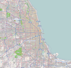
Dixmoor (formerly Specialville) is a village in Cook County, Illinois, United States and a south suburb of Chicago. The population was 2,973 at the 2020 census. [3]
Dixmoor is adjacent to Harvey to the south & east, Posen to the west, and Blue Island & Riverdale to the north. Interstate 57 also runs through the village.
Dixmoor was originally called Specialville. It was laid out in 1922 by Charles Special, and named for him. [4] The present name of Dixmoor was adopted in 1929. It may be derived from Dixie Highway. [5]
Dixmoor is located at 41°37′51″N87°39′59″W / 41.63083°N 87.66639°W (41.630784, -87.666446). [6]
According to the 2021 census gazetteer files, Dixmoor has a total area of 1.25 square miles (3.24 km2), all land. [7]
Census | Pop. | Note | %± |
---|---|---|---|
1930 | 944 | — | |
1940 | 1,022 | 8.3% | |
1950 | 1,327 | 29.8% | |
1960 | 3,076 | 131.8% | |
1970 | 4,735 | 53.9% | |
1980 | 4,175 | −11.8% | |
1990 | 3,647 | −12.6% | |
2000 | 3,934 | 7.9% | |
2010 | 3,644 | −7.4% | |
2020 | 2,973 | −18.4% | |
U.S. Decennial Census [8] 2010 [9] 2020 [10] |
As of the 2020 census [11] there were 2,973 people, 1,209 households, and 838 families residing in the village. The population density was 2,380.30 inhabitants per square mile (919.04/km2). There were 1,321 housing units at an average density of 1,057.65 per square mile (408.36/km2). The racial makeup of the village was 15.47% White, 50.92% African American, 1.58% Native American, 0.61% Asian, 0.07% Pacific Islander, 18.67% from other races, and 12.68% from two or more races. Hispanic or Latino of any race were 36.66% of the population.
There were 1,209 households, out of which 43.9% had children under the age of 18 living with them, 38.63% were married couples living together, 22.42% had a female householder with no husband present, and 30.69% were non-families. 29.36% of all households were made up of individuals, and 4.96% had someone living alone who was 65 years of age or older. The average household size was 3.72 and the average family size was 2.95.
The village's age distribution consisted of 26.7% under the age of 18, 10.4% from 18 to 24, 32.2% from 25 to 44, 20.3% from 45 to 64, and 10.4% who were 65 years of age or older. The median age was 29.9 years. For every 100 females, there were 85.7 males. For every 100 females age 18 and over, there were 86.9 males.
The median income for a household in the village was $44,757, and the median income for a family was $44,375. Males had a median income of $26,736 versus $15,552 for females. The per capita income for the village was $16,349. About 27.4% of families and 26.9% of the population were below the poverty line, including 40.5% of those under age 18 and 22.6% of those age 65 or over.
Race / Ethnicity (NH = Non-Hispanic) | Pop 2000 [12] | Pop 2010 [9] | Pop 2020 [10] | % 2000 | % 2010 | % 2020 |
---|---|---|---|---|---|---|
White (NH) | 933 | 405 | 310 | 23.72% | 11.11% | 10.43% |
Black or African American (NH) | 2,224 | 1,907 | 1,485 | 56.53% | 52.33% | 49.95% |
Native American or Alaska Native (NH) | 7 | 7 | 8 | 0.18% | 0.19% | 0.27% |
Asian (NH) | 5 | 2 | 18 | 0.13% | 0.05% | 0.61% |
Pacific Islander (NH) | 0 | 0 | 2 | 0.00% | 0.00% | 0.07% |
Other race alone (NH) | 0 | 2 | 11 | 0.00% | 0.05% | 0.37% |
Mixed race or Multiracial (NH) | 49 | 26 | 49 | 1.25% | 0.71% | 1.65% |
Hispanic or Latino (any race) | 716 | 1,295 | 1,090 | 18.20% | 35.54% | 36.66% |
Total | 3,934 | 3,644 | 2,973 | 100.00% | 100.00% | 100.00% |
Dixmoor is divided between two congressional districts. The area east of Interstate 57 and south of 142nd Street is in Illinois's 2nd congressional district, as are the area between 141st and 142nd Streets east of Wood Street and the area northeast of the Ashland Avenue-Thornton Road intersection; the rest of the village is in the 1st district.
Pace provides bus service on routes 349 and 354 connecting Dixmoor to destinations across the Southland. [13]
Bedford Park is a village in Cook County, Illinois, United States, and is an industrial suburb of Chicago. The population was 602 at the 2020 census. Bedford Park consists of a small residential area and vast amounts of heavy industry sprawling to the east and a small amount to the west.
Broadview is a village in Cook County, Illinois, 12 miles (19 km) west of downtown Chicago. As of the 2020 census it had a population of 7,998.
Burnham is a village in Cook County, Illinois, United States. The population was 4,046 at the 2020 census. The ZIP code is 60633.
Dolton is a village in Cook County, Illinois, United States. The population was 21,426 at the 2020 census. Dolton is located just west of the expressway Interstate 94 and immediately south of the city limits of Chicago. Its most common ZIP code is 60419.
East Hazel Crest is a village in Cook County, Illinois, in the United States. It is a south suburb of Chicago. As of the 2020 census, the village population was 1,297.
Forest View is a village in Cook County, Illinois, United States. Per the 2020 census, the population was 792. It is primarily an industrial corridor adjacent to the Chicago neighborhood of Garfield Ridge, which is on the village's southern border.
Glenwood is a village in Cook County, Illinois, United States. The population was 8,662 at the 2020 census.
Harvey is a city in Cook County, Illinois, United States. The population was 20,324 at the 2020 census.
Lynwood is a village in Cook County, Illinois, United States and a suburb of Chicago. The population was 9,116 at the 2020 census.
Markham is a city and a south suburb of Chicago in Cook County, Illinois, United States. The population was 11,661 at the 2020 census.
Merrionette Park is a village in Cook County, Illinois, United States. The population was 1,969 as of the 2020 census.
Phoenix is a village in Cook County, Illinois, United States. The population was 1,708 at the 2020 census. It is located approximately 19 miles (31 km) south of the Chicago Loop in the Chicago area.
Posen is a village in Cook County, Illinois, United States. Posen is the German-language name for the western Polish city of Poznań. The population of the village was 5,632 at the 2020 census.
Richton Park is a village and a south suburb of Chicago in Cook County, Illinois, United States. The population was 12,775 at the 2020 census.
Riverdale is a village in Cook County, Illinois, United States. The population was 10,663 at the 2020 census. The village shares its name with the bordering Riverdale neighborhood in Chicago.
South Chicago Heights is a village and a south suburb in Cook County, Illinois, United States. The population was 4,026 at the 2020 census.
South Holland is a village and south suburb of Chicago in Cook County, Illinois, United States, within Thornton Township. The population was 21,465 at the 2020 census.
Thornton is a village in Cook County, Illinois, United States and a south suburb of Chicago. The population was 2,386 at the 2020 census. Thornton is home to the Thornton Quarry, one of the largest quarries in the world.
Wallace is a census-designated place (CDP) in St. John the Baptist Parish, Louisiana, United States. The population was 570 at the 2000 census. It is part of the New Orleans–Metairie–Kenner Metropolitan Statistical Area. The rural community is on the west bank of the Mississippi River and easily accessible to Interstate 10 via the Gramercy Bridge.
Thornton Township is one of 29 townships in Cook County, Illinois. As of the 2020 census, its population was 157,865.
{{cite web}}
: |last=
has generic name (help)